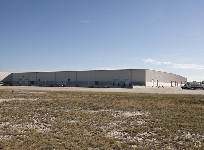
Property Record
6700 Paredes Line Rd, Brownsville, TX 78526


NEARBY LISTINGS FOR SALE OR LEASE
Property Detail
6700 Paredes Line Rd
Brownsville-Harlingen, TX
Espiritu Santo Grant Share 19
791900-0380-040000
ESPIRITU SANTO GRANT SHARE 19, 83.421 ACS OUT OF 110.693 OUT OF 184.202 ACS OF PAREDES PARTITION TRACT 38 ABST 2, 83.421 ACRES
Industrialgeneral
Cameron
X
Texas
48061C0580F
400
2024
83.42 AC
2025
Greater Brownsville
014404
Brownsville/Harlingen
1,019,535 SF
DEMOGRAPHICS near 6700 Paredes Line Rd
1 Mile
3 Mile
5 Mile
2024 Total Population
4,148
40,661
114,752
2029 Population
4,335
41,412
117,400
Pop Growth 2024-2029
+ 4.51%
+ 1.85%
+ 2.31%
Average Age
33
35
35
2024 Total Households
1,212
11,955
35,379
HH Growth 2024-2029
+ 4.46%
+ 1.87%
+ 2.34%
Median Household Inc
$68,409
$69,361
$60,562
Avg Household Size
3.40
3.30
3.20
2024 Avg HH Vehicles
2.00
2.00
2.00
Median Home Value
$238,114
$152,148
$142,196
Median Year Built
2007
2001
1998
Nearby Places
Map Layers
Map Styles
 Street
 Aerial
- Restaurants
- Banks
- Shops
- Fitness
- Groceries
PUBLIC TRANSPORTATION
AIRPORT
Brownsville/South Padre Island International
DRIVE
WALK
Distance
Brownsville/South Padre Island International
17 min
9.4 mi
Valley International
DRIVE
WALK
Distance
Valley International
31 min
23.0 mi
Freight Ports
Port of Brownsville
DRIVE
WALK
Distance
Port of Brownsville
10 min
7.4 mi
SALE & LEASE HISTORY
LISTING DATE
SALE/LEASE

Aug 10, 2021
For Sale
Apr 08, 2021
For Lease
Nearby Properties
Address
Land Use
TOTAL SIZE
Lot Size
Zoning
Address
Land Use
TOTAL SIZE
Lot Size
Zoning
232,467 SF
25.82 AC
C
Address
Land Use
TOTAL SIZE
Lot Size
Zoning
112,834 SF
16.70 AC
C
Address
Land Use
TOTAL SIZE
Lot Size
Zoning
135,686 SF
19.05 AC
C
Address
Land Use
TOTAL SIZE
Lot Size
Zoning
196,847 SF
19.63 AC
Address
Land Use
TOTAL SIZE
Lot Size
Zoning
145,218 SF
23.16 AC
Address
Land Use
TOTAL SIZE
Lot Size
Zoning
100,491 SF
14 AC
C
Address
Land Use
TOTAL SIZE
Lot Size
Zoning
56,804 SF
1.83 AC
Address
Land Use
TOTAL SIZE
Lot Size
Zoning
62,344 SF
2.92 AC
Address
Land Use
TOTAL SIZE
Lot Size
Zoning
204,001 SF
20.13 AC
C
Address
Land Use
TOTAL SIZE
Lot Size
Zoning
102,042 SF
8.68 AC
C
Address
Land Use
TOTAL SIZE
Lot Size
Zoning
78,583 SF
5.01 AC
C
Address
Land Use
TOTAL SIZE
Lot Size
Zoning
72,320 SF
27.36 AC
Address
Land Use
TOTAL SIZE
Lot Size
Zoning
86,682 SF
25.76 AC
C
Address
Land Use
TOTAL SIZE
Lot Size
Zoning
46,381 SF
2.16 AC
Address
Land Use
TOTAL SIZE
Lot Size
Zoning
71,229 SF
12.58 AC
Address
Land Use
TOTAL SIZE
Lot Size
Zoning
55,880 SF
5 AC
Address
Land Use
TOTAL SIZE
Lot Size
Zoning
117,600 SF
2.16 AC
Address
Land Use
TOTAL SIZE
Lot Size
Zoning
104,978 SF
20 AC
Address
Land Use
TOTAL SIZE
Lot Size
Zoning
46,656 SF
1.59 AC
C
Address
Land Use
TOTAL SIZE
Lot Size
Zoning
130,269 SF
8.38 AC
Address
Land Use
TOTAL SIZE
Lot Size
Zoning
130,156 SF
13.82 AC
C
Address
Land Use
TOTAL SIZE
Lot Size
Zoning
78,701 SF
9.18 AC
Address
Land Use
TOTAL SIZE
Lot Size
Zoning
80,379 SF
8.27 AC
Address
Land Use
TOTAL SIZE
Lot Size
Zoning
37,347 SF
1.15 AC
C
Address
Land Use
TOTAL SIZE
Lot Size
Zoning
58,880 SF
8.27 AC
Address
Land Use
TOTAL SIZE
Lot Size
Zoning
80,500 SF
8.12 AC
Address
Land Use
TOTAL SIZE
Lot Size
Zoning
60,790 SF
5.90 AC
Address
Land Use
TOTAL SIZE
Lot Size
Zoning
155,375 SF
9.69 AC
Address
Land Use
TOTAL SIZE
Lot Size
Zoning
60,838 SF
5.32 AC
The World's #1 Commercial Real Estate Marketplace
Connect with us
© 2026 CoStar Group
The information above has been obtained from sources believed reliable. While we do not doubt its accuracy we have not verified it and make no guarantee, warranty or representation about it. It is your responsibility to independently confirm its accuracy and completeness. Any projections, opinions, assumptions, or estimates used are for example only and do not represent the current or future performance of the property. The value of this transaction to you depends on tax and other factors which should be evaluated by your tax, financial, and legal advisors. You and your advisors should conduct a careful, independent investigation of the property to determine to your satisfaction the suitability of the property for your needs.