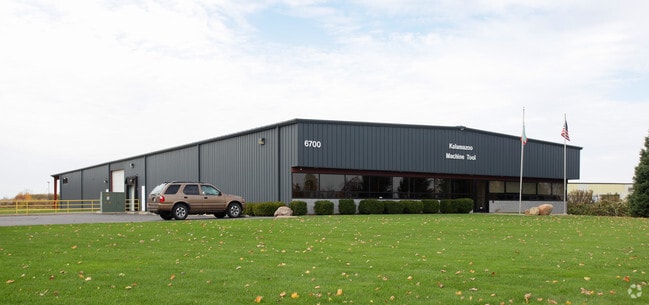
Property Record
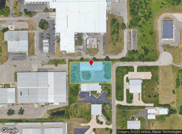
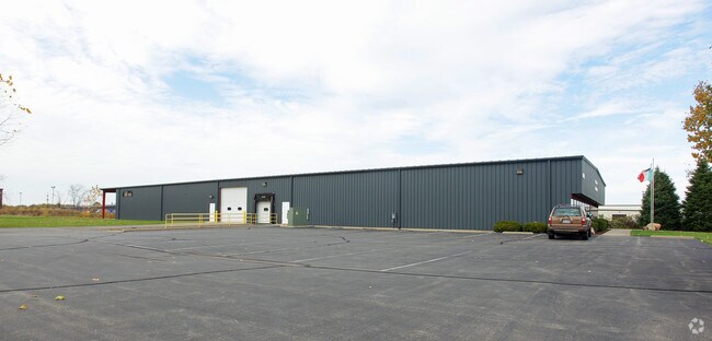
6700 Quality Way, Portage, MI 49002
NEARBY LISTINGS FOR SALE OR LEASE
Property Detail
6700 Quality Way
10-00012-115-W
SEC.12 T3S R11WPART SE1/4 COM N00DEG 00'04"W 967 FT & N89DEG 19'02"E 356.61 FT & N00DEG 00'04"W 305.40 FT & N89DEG 21'53"E
Industrialgeneral
Kalamazoo
X
Michigan
26077C0310E
1.91 AC
2024
Southern Kalamazoo County
2025
West Michigan
001905
Kalamazoo-Portage, MI
8,080 SF
DEMOGRAPHICS near 6700 Quality Way
1 Mile
3 Mile
5 Mile
2024 Total Population
1,461
21,651
77,789
2029 Population
1,450
21,527
77,528
Pop Growth 2024-2029
(0.75%)
(0.57%)
(0.34%)
Average Age
37
39
39
2024 Total Households
590
9,563
32,451
HH Growth 2024-2029
(0.68%)
(0.65%)
(0.39%)
Median Household Inc
$66,607
$56,722
$62,080
Avg Household Size
2.30
2.20
2.30
2024 Avg HH Vehicles
2.00
2.00
2.00
Median Home Value
$199,701
$162,971
$183,702
Median Year Built
1969
1968
1965
Nearby Places
Map Layers
Map Styles
 Street
 Aerial
- Restaurants
- Banks
- Shops
- Fitness
- Groceries
PUBLIC TRANSPORTATION
COMMUTER RAIL
Kalamazoo (Blue Water - Amtrak, Wolverine - Amtrak)
DRIVE
WALK
Distance
Kalamazoo (Blue Water - Amtrak, Wolverine - Amtrak)
14 min
7.6 mi
AIRPORT
Kalamazoo/Battle Creek International
DRIVE
WALK
Distance
Kalamazoo/Battle Creek International
11 min
3.4 mi
Freight Ports
Port of Toledo
DRIVE
WALK
Distance
Port of Toledo
175 min
144.2 mi
Nearby Properties
Address
Land Use
TOTAL SIZE
Lot Size
Zoning
Address
Land Use
TOTAL SIZE
Lot Size
Zoning
435.98 AC
I-2
Address
Land Use
TOTAL SIZE
Lot Size
Zoning
Address
Land Use
TOTAL SIZE
Lot Size
Zoning
Address
Land Use
TOTAL SIZE
Lot Size
Zoning
82,520 SF
39.35 AC
I-1
Address
Land Use
TOTAL SIZE
Lot Size
Zoning
35,119 SF
50.85 AC
RM-1
Address
Land Use
TOTAL SIZE
Lot Size
Zoning
78.75 AC
I-2
Address
Land Use
TOTAL SIZE
Lot Size
Zoning
33.60 AC
Address
Land Use
TOTAL SIZE
Lot Size
Zoning
Address
Land Use
TOTAL SIZE
Lot Size
Zoning
Address
Land Use
TOTAL SIZE
Lot Size
Zoning
Address
Land Use
TOTAL SIZE
Lot Size
Zoning
37.40 AC
I-2
Address
Land Use
TOTAL SIZE
Lot Size
Zoning
61.61 AC
Address
Land Use
TOTAL SIZE
Lot Size
Zoning
19.39 AC
OTR
Address
Land Use
TOTAL SIZE
Lot Size
Zoning
383,638 SF
25.85 AC
B-2
Address
Land Use
TOTAL SIZE
Lot Size
Zoning
37.40 AC
I-2
Address
Land Use
TOTAL SIZE
Lot Size
Zoning
16.71 AC
B-2
Address
Land Use
TOTAL SIZE
Lot Size
Zoning
255,452 SF
20.57 AC
Address
Land Use
TOTAL SIZE
Lot Size
Zoning
134,876 SF
16.45 AC
RM-15
Address
Land Use
TOTAL SIZE
Lot Size
Zoning
35.87 AC
I-1
Address
Land Use
TOTAL SIZE
Lot Size
Zoning
17,858 SF
15.27 AC
RM-1
Address
Land Use
TOTAL SIZE
Lot Size
Zoning
498,424 SF
41.72 AC
M-2
Address
Land Use
TOTAL SIZE
Lot Size
Zoning
18.57 AC
Address
Land Use
TOTAL SIZE
Lot Size
Zoning
298,908 SF
40.33 AC
Address
Land Use
TOTAL SIZE
Lot Size
Zoning
228,368 SF
9.60 AC
PUD
Address
Land Use
TOTAL SIZE
Lot Size
Zoning
606,439 SF
34.61 AC
M-2
Address
Land Use
TOTAL SIZE
Lot Size
Zoning
Address
Land Use
TOTAL SIZE
Lot Size
Zoning
202,798 SF
17.67 AC
I-1
Address
Land Use
TOTAL SIZE
Lot Size
Zoning
Address
Land Use
TOTAL SIZE
Lot Size
Zoning
28.49 AC
I-2
Address
Land Use
TOTAL SIZE
Lot Size
Zoning
291,184 SF
26.35 AC
I-1
The World's #1 Commercial Real Estate Marketplace
Connect with us
© 2025 CoStar Group
The information above has been obtained from sources believed reliable. While we do not doubt its accuracy we have not verified it and make no guarantee, warranty or representation about it. It is your responsibility to independently confirm its accuracy and completeness. Any projections, opinions, assumptions, or estimates used are for example only and do not represent the current or future performance of the property. The value of this transaction to you depends on tax and other factors which should be evaluated by your tax, financial, and legal advisors. You and your advisors should conduct a careful, independent investigation of the property to determine to your satisfaction the suitability of the property for your needs.