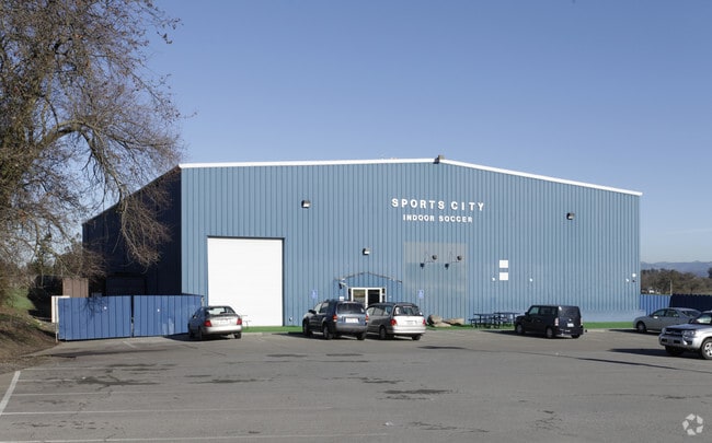
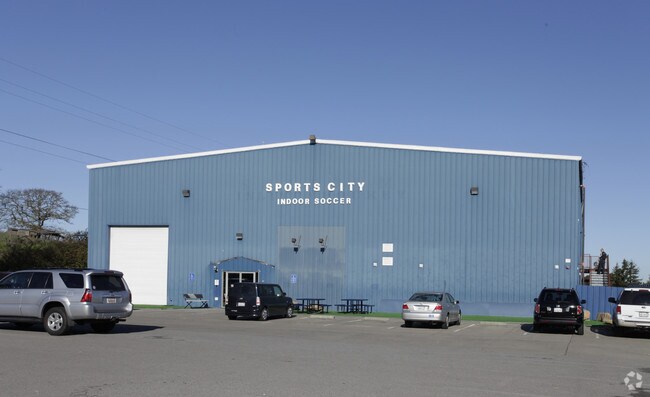
Property Record
6700 Stony Point Rd, Cotati, CA 94931


Save to a Folder
{{folder.Name}}
{{folder.ListingIds.length}} Properties
{{folder.ListingIds.length}} Property
Create a New Folder
Property Detail
6700 Stony Point Rd
046-092-018
76 FORM 46-092-12 C/W 09 & PT TO 19 MD
Commercialbuilding
Sonoma
RR
California
B and X Area of moderate flood hazard, usually the area between the limits of the 100-year and 500-year floods.
31-34
2025
13.18 AC
2025
Petaluma/Cotati/Rohnert
151206
North Bay/Santa Rosa
20,000 SF
Santa Rosa-Petaluma, CA
NEARBY LISTINGS FOR SALE OR LEASE
DEMOGRAPHICS near 6700 Stony Point Rd
1 mile
3 mile
5 mile
2025 Total Population
626
41,360
73,943
2030 Population
595
41,347
73,559
Pop Growth 2025-2030
(4.95%)
(0.03%)
(0.52%)
Average Age
45
40
40
2025 Total Households
238
15,894
26,801
HH Growth 2025-2030
(4.62%)
(0.09%)
(0.60%)
Median Household Inc
$109,482
$94,031
$98,700
Avg Household Size
2.60
2.50
2.60
2025 Avg HH Vehicles
3.00
2.00
2.00
Median Home Value
$868,243
$680,397
$726,398
Median Year Built
1973
1979
1980
Nearby Places
Map Layers
Map Styles
 Street
 Aerial
Layers
 Traffic
 Biking
Places
Listings with unknown addresses are not visible on the map
- Restaurants
- Banks
- Shops
- Fitness
- Groceries
PUBLIC TRANSPORTATION
COMMUTER RAIL
Drive
Walk
Distance
13 min
7.6 mi
AIRPORT
Charles M Schulz - Sonoma County
Drive
Walk
Distance
Charles M Schulz - Sonoma County
25 min
17.6 mi
Nearby Properties
Address
Land Use
TOTAL SIZE
Lot Size
Zoning
Address
Land Use
TOTAL SIZE
Lot Size
Zoning
23,112 SF
12.30 AC
Address
Land Use
TOTAL SIZE
Lot Size
Zoning
4,652 SF
11.09 AC
MLPD
Address
Land Use
TOTAL SIZE
Lot Size
Zoning
26,699 SF
6 AC
MLPD
Address
Land Use
TOTAL SIZE
Lot Size
Zoning
29,235 SF
8.08 AC
Address
Land Use
TOTAL SIZE
Lot Size
Zoning
181,816 SF
8.64 AC
Address
Land Use
TOTAL SIZE
Lot Size
Zoning
10,134 SF
3.03 AC
RM
Address
Land Use
TOTAL SIZE
Lot Size
Zoning
12,640 SF
4.94 AC
CITYRP
Address
Land Use
TOTAL SIZE
Lot Size
Zoning
389.05 AC
Address
Land Use
TOTAL SIZE
Lot Size
Zoning
12,491 SF
5.40 AC
MLPD
Address
Land Use
TOTAL SIZE
Lot Size
Zoning
149,007 SF
0.25 AC
M1RP
Address
Land Use
TOTAL SIZE
Lot Size
Zoning
7,745 SF
2.28 AC
Address
Land Use
TOTAL SIZE
Lot Size
Zoning
55,826 SF
13.15 AC
CRPD
Address
Land Use
TOTAL SIZE
Lot Size
Zoning
61,880 SF
2.53 AC
Address
Land Use
TOTAL SIZE
Lot Size
Zoning
107,599 SF
2.98 AC
Address
Land Use
TOTAL SIZE
Lot Size
Zoning
67,584 SF
4.79 AC
CITYRP
Address
Land Use
TOTAL SIZE
Lot Size
Zoning
144,198 SF
12.08 AC
CRPD
Address
Land Use
TOTAL SIZE
Lot Size
Zoning
26,390 SF
3.33 AC
MLPD
Address
Land Use
TOTAL SIZE
Lot Size
Zoning
5,760 SF
4.77 AC
CITYRP
Address
Land Use
TOTAL SIZE
Lot Size
Zoning
38,830 SF
2.09 AC
CITYRP
Address
Land Use
TOTAL SIZE
Lot Size
Zoning
138,134 SF
12.54 AC
C1
Address
Land Use
TOTAL SIZE
Lot Size
Zoning
85,844 SF
2.34 AC
MLPD
Address
Land Use
TOTAL SIZE
Lot Size
Zoning
55,387 SF
3.07 AC
CITYRP
Address
Land Use
TOTAL SIZE
Lot Size
Zoning
81,712 SF
5.64 AC
CITYRP
Address
Land Use
TOTAL SIZE
Lot Size
Zoning
69,431 SF
4.69 AC
Address
Land Use
TOTAL SIZE
Lot Size
Zoning
15,505 SF
2.34 AC
Address
Land Use
TOTAL SIZE
Lot Size
Zoning
77,857 SF
6.69 AC
CITYRP
Address
Land Use
TOTAL SIZE
Lot Size
Zoning
4,154 SF
5.50 AC
CITYRP
Address
Land Use
TOTAL SIZE
Lot Size
Zoning
4,992 SF
2.78 AC
Address
Land Use
TOTAL SIZE
Lot Size
Zoning
2,750 SF
6.25 AC
MR
Address
Land Use
TOTAL SIZE
Lot Size
Zoning
58,407 SF
4.40 AC
MLPD
The World's #1 Commercial Real Estate Marketplace
Connect with us
© 2026 CoStar Group
The information above has been obtained from sources believed reliable. While we do not doubt its accuracy we have not verified it and make no guarantee, warranty or representation about it. It is your responsibility to independently confirm its accuracy and completeness. Any projections, opinions, assumptions, or estimates used are for example only and do not represent the current or future performance of the property. The value of this transaction to you depends on tax and other factors which should be evaluated by your tax, financial, and legal advisors. You and your advisors should conduct a careful, independent investigation of the property to determine to your satisfaction the suitability of the property for your needs.