Property Record
6701 Airport Blvd, Mobile, AL 36608
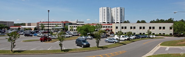
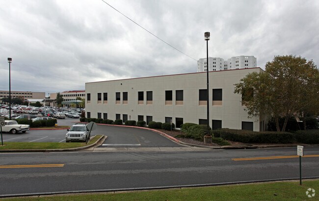
Property Detail
6701 Airport Blvd
Mobile, AL
LOT 3 PBC SUBDIVISION MBK 119 PAGE 100
28-04-20-4-000-107.005
Mobile
Medicalbuilding
Alabama
B and X Area of moderate flood hazard, usually the area between the limits of the 100-year and 500-year floods.
3
0
1.21 AC
2025
West Mobile
003703
Mobile
159,052 SF
NEARBY LISTINGS FOR SALE OR LEASE
DEMOGRAPHICS near 6701 Airport Blvd
1 mile
3 mile
5 mile
2025 Total Population
9,698
58,674
130,345
2030 Population
9,585
57,479
127,894
Pop Growth 2025-2030
(1.17%)
(2.04%)
(1.88%)
Average Age
37
38
39
2025 Total Households
4,561
24,408
52,929
HH Growth 2025-2030
(1.23%)
(2.16%)
(2.00%)
Median Household Inc
$43,984
$55,587
$59,654
Avg Household Size
2.10
2.30
2.30
2025 Avg HH Vehicles
1.00
2.00
2.00
Median Home Value
$247,754
$241,267
$230,286
Median Year Built
1985
1983
1982
Nearby Places
Map Layers
Map Styles
 Street
 Aerial
Layers
 Traffic
 Biking
Places
Listings with unknown addresses are not visible on the map
- Restaurants
- Banks
- Shops
- Fitness
- Groceries
PUBLIC TRANSPORTATION
AIRPORT
Mobile Regional
Drive
Walk
Distance
Mobile Regional
13 min
4.5 mi
Mobile International
Drive
Walk
Distance
Mobile International
20 min
11.5 mi
Freight Ports
Port of Mobile
Drive
Walk
Distance
Port of Mobile
23 min
11.1 mi
SALE & LEASE HISTORY
LISTING DATE
SALE/LEASE

Oct 06, 2020
For Lease
Nearby Properties
Address
Land Use
TOTAL SIZE
Lot Size
Zoning
Address
Land Use
TOTAL SIZE
Lot Size
Zoning
170,500 SF
154.49 AC
Address
Land Use
TOTAL SIZE
Lot Size
Zoning
549,081 SF
15.70 AC
Address
Land Use
TOTAL SIZE
Lot Size
Zoning
142,425 SF
160 AC
Address
Land Use
TOTAL SIZE
Lot Size
Zoning
216,528 SF
159 AC
Address
Land Use
TOTAL SIZE
Lot Size
Zoning
32,394 SF
40 AC
Address
Land Use
TOTAL SIZE
Lot Size
Zoning
230,009 SF
97.56 AC
Address
Land Use
TOTAL SIZE
Lot Size
Zoning
250,368 SF
317 AC
Address
Land Use
TOTAL SIZE
Lot Size
Zoning
25,536 SF
24 AC
Address
Land Use
TOTAL SIZE
Lot Size
Zoning
101,225 SF
142 AC
Address
Land Use
TOTAL SIZE
Lot Size
Zoning
34,801 SF
21.88 AC
Address
Land Use
TOTAL SIZE
Lot Size
Zoning
6,172 SF
23.43 AC
Address
Land Use
TOTAL SIZE
Lot Size
Zoning
26,400 SF
256.19 AC
Address
Land Use
TOTAL SIZE
Lot Size
Zoning
105,921 SF
17.90 AC
Address
Land Use
TOTAL SIZE
Lot Size
Zoning
88,588 SF
13.01 AC
Address
Land Use
TOTAL SIZE
Lot Size
Zoning
119,648 SF
38.21 AC
Address
Land Use
TOTAL SIZE
Lot Size
Zoning
31,608 SF
20.30 AC
Address
Land Use
TOTAL SIZE
Lot Size
Zoning
57,452 SF
14.58 AC
Address
Land Use
TOTAL SIZE
Lot Size
Zoning
18,368 SF
14.70 AC
Address
Land Use
TOTAL SIZE
Lot Size
Zoning
31,452 SF
10.60 AC
Address
Land Use
TOTAL SIZE
Lot Size
Zoning
66,798 SF
10.31 AC
Address
Land Use
TOTAL SIZE
Lot Size
Zoning
65,356 SF
6.35 AC
Address
Land Use
TOTAL SIZE
Lot Size
Zoning
34,200 SF
30.03 AC
Address
Land Use
TOTAL SIZE
Lot Size
Zoning
19,536 SF
14.68 AC
Address
Land Use
TOTAL SIZE
Lot Size
Zoning
179,142 SF
17.12 AC
Address
Land Use
TOTAL SIZE
Lot Size
Zoning
17,240 SF
12 AC
Address
Land Use
TOTAL SIZE
Lot Size
Zoning
200,001 SF
20 AC
Address
Land Use
TOTAL SIZE
Lot Size
Zoning
9,184 SF
12 AC
Address
Land Use
TOTAL SIZE
Lot Size
Zoning
31,728 SF
8.10 AC
Address
Land Use
TOTAL SIZE
Lot Size
Zoning
62,859 SF
6.84 AC
Address
Land Use
TOTAL SIZE
Lot Size
Zoning
10,256 SF
17.90 AC
The World's #1 Commercial Real Estate Marketplace
Connect with us
© 2026 CoStar Group
The information above has been obtained from sources believed reliable. While we do not doubt its accuracy we have not verified it and make no guarantee, warranty or representation about it. It is your responsibility to independently confirm its accuracy and completeness. Any projections, opinions, assumptions, or estimates used are for example only and do not represent the current or future performance of the property. The value of this transaction to you depends on tax and other factors which should be evaluated by your tax, financial, and legal advisors. You and your advisors should conduct a careful, independent investigation of the property to determine to your satisfaction the suitability of the property for your needs.