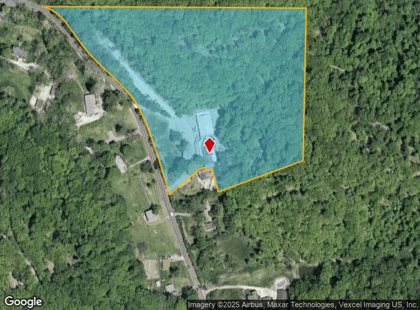
Property Record
6701 Antire Rd, High Ridge, MO 63049
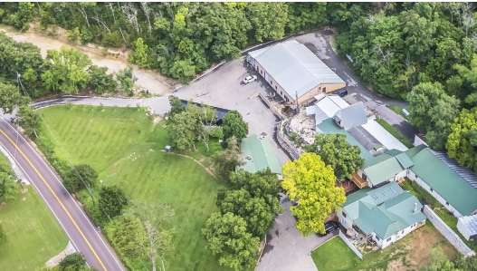
This Property Is For Sale
NEARBY LISTINGS FOR SALE OR LEASE
Property Detail
6701 Antire Rd
03-2.0-10.0-0-001-009
Viola Hills
Miscellaneous
PT NE1/4 SW1/4 & PT NW1/4 SE1/4
X
Jefferson
29099C0081F
Missouri
2024
15.34 AC
2025
Southwest County
700305
St. Louis
17,933 SF
St. Louis, MO-IL
DEMOGRAPHICS near 6701 Antire Rd
1 Mile
3 Mile
5 Mile
2024 Total Population
817
15,290
50,294
2029 Population
827
15,503
50,860
Pop Growth 2024-2029
+ 1.22%
+ 1.39%
+ 1.13%
Average Age
45
42
41
2024 Total Households
329
6,053
18,804
HH Growth 2024-2029
+ 1.52%
+ 1.42%
+ 1.15%
Median Household Inc
$99,518
$84,967
$100,800
Avg Household Size
2.50
2.50
2.60
2024 Avg HH Vehicles
2.00
2.00
2.00
Median Home Value
$264,655
$217,549
$276,853
Median Year Built
1985
1984
1986
Nearby Places
- Restaurants
- Banks
- Shops
- Fitness
- Groceries
PUBLIC TRANSPORTATION
AIRPORT
St Louis Lambert International
DRIVE
WALK
Distance
St Louis Lambert International
43 min
28.8 mi
Freight Ports
Tulsa Port of Inola
DRIVE
WALK
Distance
Tulsa Port of Inola
402 min
365.0 mi
Nearby Properties
Address
Land Use
TOTAL SIZE
Lot Size
Zoning
Address
Land Use
TOTAL SIZE
Lot Size
Zoning
28,790 SF
1,196.80 AC
NU
Address
Land Use
TOTAL SIZE
Lot Size
Zoning
155,242 SF
22.76 AC
R09
Address
Land Use
TOTAL SIZE
Lot Size
Zoning
108,535 SF
14.09 AC
PUD
Address
Land Use
TOTAL SIZE
Lot Size
Zoning
560.41 AC
NU
Address
Land Use
TOTAL SIZE
Lot Size
Zoning
186,525 SF
20.80 AC
R20
Address
Land Use
TOTAL SIZE
Lot Size
Zoning
1,910 SF
5.19 AC
R40
Address
Land Use
TOTAL SIZE
Lot Size
Zoning
273,663 SF
18.81 AC
R09
Address
Land Use
TOTAL SIZE
Lot Size
Zoning
108,211 SF
15.18 AC
PI
Address
Land Use
TOTAL SIZE
Lot Size
Zoning
76,636 SF
8.41 AC
CC2
Address
Land Use
TOTAL SIZE
Lot Size
Zoning
14,328 SF
451.70 AC
PI
Address
Land Use
TOTAL SIZE
Lot Size
Zoning
22,768 SF
2.91 AC
Address
Land Use
TOTAL SIZE
Lot Size
Zoning
75,099 SF
2.74 AC
CC2
Address
Land Use
TOTAL SIZE
Lot Size
Zoning
93,250 SF
2.63 AC
PUD
Address
Land Use
TOTAL SIZE
Lot Size
Zoning
213.34 AC
PS
Address
Land Use
TOTAL SIZE
Lot Size
Zoning
15,064 SF
2.34 AC
CC2
Address
Land Use
TOTAL SIZE
Lot Size
Zoning
2,569 SF
170.54 AC
NU
Address
Land Use
TOTAL SIZE
Lot Size
Zoning
51,166 SF
6.09 AC
CC2
Address
Land Use
TOTAL SIZE
Lot Size
Zoning
6,488 SF
1.06 AC
PUD
Address
Land Use
TOTAL SIZE
Lot Size
Zoning
4,392 SF
1.71 AC
Address
Land Use
TOTAL SIZE
Lot Size
Zoning
3,426 SF
1.76 AC
Address
Land Use
TOTAL SIZE
Lot Size
Zoning
4,476 SF
1.37 AC
PUD
Address
Land Use
TOTAL SIZE
Lot Size
Zoning
2.51 AC
98C
Address
Land Use
TOTAL SIZE
Lot Size
Zoning
45,264 SF
7.21 AC
CC2
Address
Land Use
TOTAL SIZE
Lot Size
Zoning
4,310 SF
1.57 AC
CC2
Address
Land Use
TOTAL SIZE
Lot Size
Zoning
36,296 SF
13.38 AC
CC2
Address
Land Use
TOTAL SIZE
Lot Size
Zoning
11,400 SF
1.60 AC
PUD
Address
Land Use
TOTAL SIZE
Lot Size
Zoning
8,015 SF
2.23 AC
R09
Address
Land Use
TOTAL SIZE
Lot Size
Zoning
2,228 SF
1.70 AC
Address
Land Use
TOTAL SIZE
Lot Size
Zoning
11,550 SF
1.05 AC
PUD
Address
Land Use
TOTAL SIZE
Lot Size
Zoning
11,399 SF
1.42 AC
CC2
The World's #1 Commercial Real Estate Marketplace
Connect with us
© 2025 CoStar Group
The information above has been obtained from sources believed reliable. While we do not doubt its accuracy we have not verified it and make no guarantee, warranty or representation about it. It is your responsibility to independently confirm its accuracy and completeness. Any projections, opinions, assumptions, or estimates used are for example only and do not represent the current or future performance of the property. The value of this transaction to you depends on tax and other factors which should be evaluated by your tax, financial, and legal advisors. You and your advisors should conduct a careful, independent investigation of the property to determine to your satisfaction the suitability of the property for your needs.