Property Record
6701 Oaklandon Rd, Indianapolis, IN 46236


NEARBY LISTINGS FOR SALE OR LEASE
-
-
View all Indianapolis listings for sale on LoopNet.com
Property Detail
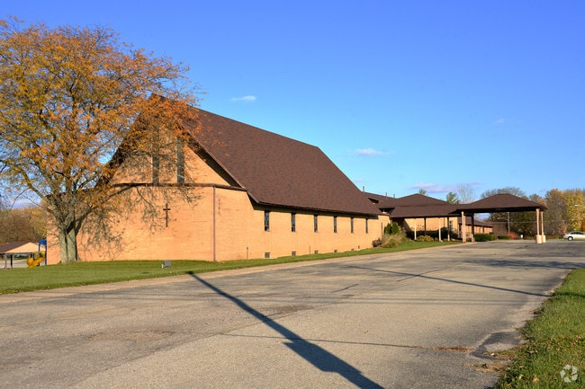
6701 Oaklandon Rd
49-01-34-125-001.000-407
Oaklandon Northeast 1St Sec
Religious
OAKLANDON NORTHEAST 1ST SEC BLOCK A & ADJACENTVACATED NORTH 1/2 TROLLEY ROAD
X
Marion
18097C0089F
Indiana
2023
7.21 AC
2024
North Shadeland
330213
Indianapolis
40,986 SF
Indianapolis-Carmel-Anderson, IN
DEMOGRAPHICS near 6701 Oaklandon Rd
1 Mile
3 Mile
5 Mile
2024 Total Population
6,484
43,197
128,892
2029 Population
6,329
43,554
131,546
Pop Growth 2024-2029
(2.39%)
+ 0.83%
+ 2.06%
Average Age
41
40
37
2024 Total Households
2,384
16,178
48,613
HH Growth 2024-2029
(2.60%)
+ 0.71%
+ 1.76%
Median Household Inc
$91,791
$98,424
$76,964
Avg Household Size
2.60
2.60
2.60
2024 Avg HH Vehicles
2.00
2.00
2.00
Median Home Value
$193,414
$245,362
$246,418
Median Year Built
1993
1995
1990
Nearby Places
Map Layers
Map Styles
 Street
 Aerial
- Restaurants
- Banks
- Shops
- Fitness
- Groceries
PUBLIC TRANSPORTATION
AIRPORT
Indianapolis International
DRIVE
WALK
Distance
Indianapolis International
50 min
28.7 mi
Freight Ports
Port of Toledo
DRIVE
WALK
Distance
Port of Toledo
254 min
210.8 mi
Nearby Properties
Address
Land Use
TOTAL SIZE
Lot Size
Zoning
Address
Land Use
TOTAL SIZE
Lot Size
Zoning
77.34 AC
Address
Land Use
TOTAL SIZE
Lot Size
Zoning
61.08 AC
Address
Land Use
TOTAL SIZE
Lot Size
Zoning
2,398 SF
64.58 AC
Address
Land Use
TOTAL SIZE
Lot Size
Zoning
67.09 AC
Address
Land Use
TOTAL SIZE
Lot Size
Zoning
11,154 SF
21.99 AC
Address
Land Use
TOTAL SIZE
Lot Size
Zoning
28.71 AC
Address
Land Use
TOTAL SIZE
Lot Size
Zoning
4,217 SF
7.37 AC
ZO01
Address
Land Use
TOTAL SIZE
Lot Size
Zoning
129,608 SF
54.85 AC
ZO01
Address
Land Use
TOTAL SIZE
Lot Size
Zoning
2,232 SF
22.88 AC
Address
Land Use
TOTAL SIZE
Lot Size
Zoning
94,472 SF
15.91 AC
Address
Land Use
TOTAL SIZE
Lot Size
Zoning
259,780 SF
20.36 AC
Address
Land Use
TOTAL SIZE
Lot Size
Zoning
136,336 SF
8.74 AC
ZO01
Address
Land Use
TOTAL SIZE
Lot Size
Zoning
43,530 SF
5.06 AC
Address
Land Use
TOTAL SIZE
Lot Size
Zoning
16,836 SF
16.90 AC
Address
Land Use
TOTAL SIZE
Lot Size
Zoning
1,769 SF
18.27 AC
Address
Land Use
TOTAL SIZE
Lot Size
Zoning
293,952 SF
12.88 AC
ZO01
Address
Land Use
TOTAL SIZE
Lot Size
Zoning
88,772 SF
20.05 AC
Address
Land Use
TOTAL SIZE
Lot Size
Zoning
109,200 SF
4.63 AC
ZO01
Address
Land Use
TOTAL SIZE
Lot Size
Zoning
28,144 SF
10.70 AC
Address
Land Use
TOTAL SIZE
Lot Size
Zoning
192,246 SF
27.51 AC
Address
Land Use
TOTAL SIZE
Lot Size
Zoning
203,720 SF
21.44 AC
Address
Land Use
TOTAL SIZE
Lot Size
Zoning
40,092 SF
8.44 AC
Address
Land Use
TOTAL SIZE
Lot Size
Zoning
151,107 SF
18.64 AC
Address
Land Use
TOTAL SIZE
Lot Size
Zoning
59,900 SF
7.82 AC
ZO01
Address
Land Use
TOTAL SIZE
Lot Size
Zoning
5,430 SF
10.29 AC
ZO01
Address
Land Use
TOTAL SIZE
Lot Size
Zoning
52,800 SF
5.28 AC
ZO01
Address
Land Use
TOTAL SIZE
Lot Size
Zoning
152,577 SF
8.94 AC
ZO01
Address
Land Use
TOTAL SIZE
Lot Size
Zoning
64,649 SF
6.95 AC
ZO01
Address
Land Use
TOTAL SIZE
Lot Size
Zoning
201,000 SF
14.57 AC
ZO01
Address
Land Use
TOTAL SIZE
Lot Size
Zoning
64,951 SF
6 AC
ZO01
The World's #1 Commercial Real Estate Marketplace
Connect with us
© 2025 CoStar Group
The information above has been obtained from sources believed reliable. While we do not doubt its accuracy we have not verified it and make no guarantee, warranty or representation about it. It is your responsibility to independently confirm its accuracy and completeness. Any projections, opinions, assumptions, or estimates used are for example only and do not represent the current or future performance of the property. The value of this transaction to you depends on tax and other factors which should be evaluated by your tax, financial, and legal advisors. You and your advisors should conduct a careful, independent investigation of the property to determine to your satisfaction the suitability of the property for your needs.