Property Record
6701 Rialto Blvd, Austin, TX 78735
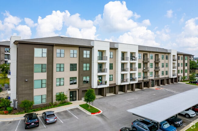

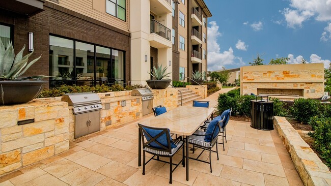

Property Detail
6701 Rialto Blvd
Austin-Round Rock-San Marcos, TX
23.594AC OF LOT 9B RIALTO PARK AT LANTANA RESUB LT 9 BLK A BLK A
865131
TRAVIS
Multifamilydwelling
Texas
B and X Area of moderate flood hazard, usually the area between the limits of the 100-year and 500-year floods.
9b,9
2025
23.59 AC
2025
East Oak Hill
001915
Austin
359,339 SF
NEARBY LISTINGS FOR SALE OR LEASE
-
-
View all Austin listings for sale on LoopNet.com
DEMOGRAPHICS near 6701 Rialto Blvd
1 mile
3 mile
5 mile
2025 Total Population
7,158
56,158
150,648
2030 Population
7,443
58,004
156,013
Pop Growth 2025-2030
+ 3.98%
+ 3.29%
+ 3.56%
Average Age
37
40
40
2025 Total Households
3,487
24,272
64,951
HH Growth 2025-2030
+ 4.85%
+ 4.07%
+ 4.32%
Median Household Inc
$117,068
$119,405
$119,618
Avg Household Size
2.00
2.20
2.30
2025 Avg HH Vehicles
2.00
2.00
2.00
Median Home Value
$821,296
$735,994
$747,693
Median Year Built
2005
1996
1994
Nearby Places
Map Layers
Map Styles
 Street
 Aerial
Layers
 Traffic
 Biking
Places
Listings with unknown addresses are not visible on the map
- Restaurants
- Banks
- Shops
- Fitness
- Groceries
PUBLIC TRANSPORTATION
COMMUTER RAIL
Austin (Texas Eagle - Amtrak)
Drive
Walk
Distance
Austin (Texas Eagle - Amtrak)
15 min
9.3 mi
AIRPORT
Austin-Bergstrom International
Drive
Walk
Distance
Austin-Bergstrom International
29 min
16.2 mi
Freight Ports
Calhoun Port
Drive
Walk
Distance
Calhoun Port
194 min
159.7 mi
Nearby Properties
Address
Land Use
TOTAL SIZE
Lot Size
Zoning
Address
Land Use
TOTAL SIZE
Lot Size
Zoning
632.50 AC
Address
Land Use
TOTAL SIZE
Lot Size
Zoning
881,940 SF
80.11 AC
Address
Land Use
TOTAL SIZE
Lot Size
Zoning
881,498 SF
58.79 AC
Address
Land Use
TOTAL SIZE
Lot Size
Zoning
617,120 SF
53.40 AC
Address
Land Use
TOTAL SIZE
Lot Size
Zoning
456,600 SF
44.89 AC
Address
Land Use
TOTAL SIZE
Lot Size
Zoning
474,907 SF
36.94 AC
Address
Land Use
TOTAL SIZE
Lot Size
Zoning
422,810 SF
46.50 AC
Address
Land Use
TOTAL SIZE
Lot Size
Zoning
398,436 SF
30.81 AC
Address
Land Use
TOTAL SIZE
Lot Size
Zoning
432,404 SF
37.29 AC
Address
Land Use
TOTAL SIZE
Lot Size
Zoning
392,093 SF
24.02 AC
Address
Land Use
TOTAL SIZE
Lot Size
Zoning
267,224 SF
56.90 AC
Address
Land Use
TOTAL SIZE
Lot Size
Zoning
324,860 SF
8.36 AC
Address
Land Use
TOTAL SIZE
Lot Size
Zoning
425,720 SF
28.49 AC
Address
Land Use
TOTAL SIZE
Lot Size
Zoning
355,651 SF
31.86 AC
Address
Land Use
TOTAL SIZE
Lot Size
Zoning
404,812 SF
31.32 AC
Address
Land Use
TOTAL SIZE
Lot Size
Zoning
286,988 SF
27.73 AC
Address
Land Use
TOTAL SIZE
Lot Size
Zoning
258,600 SF
36.81 AC
Address
Land Use
TOTAL SIZE
Lot Size
Zoning
324,135 SF
53.12 AC
Address
Land Use
TOTAL SIZE
Lot Size
Zoning
233,943 SF
39.66 AC
Address
Land Use
TOTAL SIZE
Lot Size
Zoning
267,928 SF
18.13 AC
Address
Land Use
TOTAL SIZE
Lot Size
Zoning
253,902 SF
28.21 AC
Address
Land Use
TOTAL SIZE
Lot Size
Zoning
255,144 SF
6.62 AC
Address
Land Use
TOTAL SIZE
Lot Size
Zoning
278,740 SF
44.30 AC
Address
Land Use
TOTAL SIZE
Lot Size
Zoning
240,640 SF
14.36 AC
Address
Land Use
TOTAL SIZE
Lot Size
Zoning
262,421 SF
33.65 AC
Address
Land Use
TOTAL SIZE
Lot Size
Zoning
307,584 SF
39.67 AC
Address
Land Use
TOTAL SIZE
Lot Size
Zoning
126.95 AC
Address
Land Use
TOTAL SIZE
Lot Size
Zoning
150,975 SF
35.79 AC
Address
Land Use
TOTAL SIZE
Lot Size
Zoning
295,322 SF
23.02 AC
The World's #1 Commercial Real Estate Marketplace
Connect with us
© 2026 CoStar Group
The information above has been obtained from sources believed reliable. While we do not doubt its accuracy we have not verified it and make no guarantee, warranty or representation about it. It is your responsibility to independently confirm its accuracy and completeness. Any projections, opinions, assumptions, or estimates used are for example only and do not represent the current or future performance of the property. The value of this transaction to you depends on tax and other factors which should be evaluated by your tax, financial, and legal advisors. You and your advisors should conduct a careful, independent investigation of the property to determine to your satisfaction the suitability of the property for your needs.