Property Record
Selmore Rd, Ozark, MO 65721
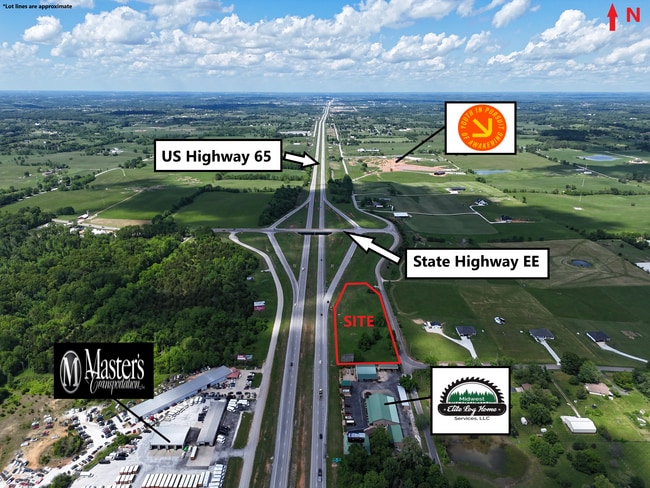

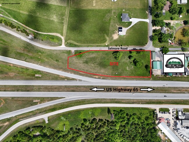
This Property Is For Sale
NEARBY LISTINGS FOR SALE OR LEASE
-
-
View all Ozark listings for sale on LoopNet.com
Property Detail
Selmore Rd
Springfield, MO
Ozark Out
18-0.5-21-000-000-021.001
S 630 SE NE LYING E OF HWY 65.
Agriculturalland
Christian
X
Missouri
29043C0230D
2.60 AC
2023
East Christian County
2024
Springfield
020304
DEMOGRAPHICS near Selmore Rd
1 Mile
3 Mile
5 Mile
2024 Total Population
447
2,944
13,353
2029 Population
535
3,514
15,984
Pop Growth 2024-2029
+ 19.69%
+ 19.36%
+ 19.70%
Average Age
45
44
41
2024 Total Households
167
1,101
4,963
HH Growth 2024-2029
+ 19.76%
+ 19.53%
+ 19.79%
Median Household Inc
$98,706
$74,062
$67,448
Avg Household Size
2.70
2.70
2.70
2024 Avg HH Vehicles
3.00
3.00
2.00
Median Home Value
$369,148
$322,511
$236,968
Median Year Built
2005
1999
1996
Nearby Places
Map Layers
Map Styles
 Street
 Aerial
- Restaurants
- Banks
- Shops
- Fitness
- Groceries
PUBLIC TRANSPORTATION
AIRPORT
Springfield-Branson Ntl
DRIVE
WALK
Distance
Springfield-Branson Ntl
48 min
34.7 mi
Nearby Properties
Address
Land Use
TOTAL SIZE
Lot Size
Zoning
Address
Land Use
TOTAL SIZE
Lot Size
Zoning
Address
Land Use
TOTAL SIZE
Lot Size
Zoning
37,888 SF
7 AC
Address
Land Use
TOTAL SIZE
Lot Size
Zoning
400 SF
79 AC
Address
Land Use
TOTAL SIZE
Lot Size
Zoning
2,000 SF
9.10 AC
Address
Land Use
TOTAL SIZE
Lot Size
Zoning
16,490 SF
1.40 AC
Address
Land Use
TOTAL SIZE
Lot Size
Zoning
4,466 SF
2.94 AC
Address
Land Use
TOTAL SIZE
Lot Size
Zoning
12,566 SF
1.85 AC
Address
Land Use
TOTAL SIZE
Lot Size
Zoning
7,200 SF
1.70 AC
Address
Land Use
TOTAL SIZE
Lot Size
Zoning
2,000 SF
9.47 AC
Address
Land Use
TOTAL SIZE
Lot Size
Zoning
10,648 SF
78.38 AC
Address
Land Use
TOTAL SIZE
Lot Size
Zoning
8,000 SF
3.94 AC
Address
Land Use
TOTAL SIZE
Lot Size
Zoning
5,290 SF
1.50 AC
Address
Land Use
TOTAL SIZE
Lot Size
Zoning
5,500 SF
43.18 AC
Address
Land Use
TOTAL SIZE
Lot Size
Zoning
1,920 SF
5.97 AC
Address
Land Use
TOTAL SIZE
Lot Size
Zoning
1,896 SF
4.58 AC
Address
Land Use
TOTAL SIZE
Lot Size
Zoning
13.88 AC
Address
Land Use
TOTAL SIZE
Lot Size
Zoning
12,250 SF
4 AC
Address
Land Use
TOTAL SIZE
Lot Size
Zoning
10,000 SF
1.76 AC
Address
Land Use
TOTAL SIZE
Lot Size
Zoning
10,336 SF
0.45 AC
Address
Land Use
TOTAL SIZE
Lot Size
Zoning
7,182 SF
0.38 AC
Address
Land Use
TOTAL SIZE
Lot Size
Zoning
6,560 SF
9.37 AC
Address
Land Use
TOTAL SIZE
Lot Size
Zoning
3,360 SF
2.01 AC
Address
Land Use
TOTAL SIZE
Lot Size
Zoning
3,307 SF
2.85 AC
Address
Land Use
TOTAL SIZE
Lot Size
Zoning
6,750 SF
0.23 AC
Address
Land Use
TOTAL SIZE
Lot Size
Zoning
4,735 SF
80 AC
Address
Land Use
TOTAL SIZE
Lot Size
Zoning
3,200 SF
10.19 AC
Address
Land Use
TOTAL SIZE
Lot Size
Zoning
10,848 SF
4.58 AC
Address
Land Use
TOTAL SIZE
Lot Size
Zoning
2,881 SF
5 AC
Address
Land Use
TOTAL SIZE
Lot Size
Zoning
4,600 SF
8.59 AC
Address
Land Use
TOTAL SIZE
Lot Size
Zoning
4,157 SF
13.97 AC
The World's #1 Commercial Real Estate Marketplace
Connect with us
© 2025 CoStar Group
The information above has been obtained from sources believed reliable. While we do not doubt its accuracy we have not verified it and make no guarantee, warranty or representation about it. It is your responsibility to independently confirm its accuracy and completeness. Any projections, opinions, assumptions, or estimates used are for example only and do not represent the current or future performance of the property. The value of this transaction to you depends on tax and other factors which should be evaluated by your tax, financial, and legal advisors. You and your advisors should conduct a careful, independent investigation of the property to determine to your satisfaction the suitability of the property for your needs.