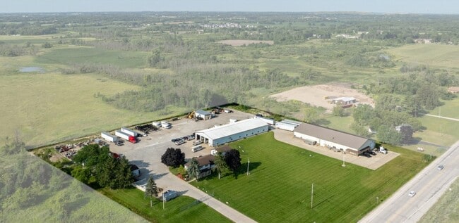
Property Record
6701 W Ryan Rd, Franklin, WI 53132


NEARBY LISTINGS FOR SALE OR LEASE
Property Detail
6701 W Ryan Rd
898-9999-000
N 600 FT OF W 500 FT OF NE 27 5 21 EXC N 60 FT FOR STR
Commercialnec
Milwaukee
AE
Wisconsin
55101C0076D
6.20 AC
2024
SW Outlying Milwaukee
2024
Milwaukee/Madison
187200
Milwaukee-Waukesha, WI
DEMOGRAPHICS near 6701 W Ryan Rd
1 mile
3 mile
5 mile
2024 Total Population
2,475
23,162
73,604
2029 Population
2,455
22,517
72,012
Pop Growth 2024-2029
(0.81%)
(2.78%)
(2.16%)
Average Age
38
43
42
2024 Total Households
398
8,694
29,757
HH Growth 2024-2029
(2.26%)
(3.05%)
(2.23%)
Median Household Inc
$139,772
$104,127
$87,077
Avg Household Size
2.60
2.50
2.40
2024 Avg HH Vehicles
2.00
2.00
2.00
Median Home Value
$358,904
$326,865
$298,676
Median Year Built
1998
1990
1985
Nearby Places
Map Layers
Map Styles
 Street
 Aerial
Transit
 Traffic
 Biking
Places
Listings with unknown addresses are not visible on the map
- Restaurants
- Banks
- Shops
- Fitness
- Groceries
PUBLIC TRANSPORTATION
COMMUTER RAIL
General Mitchell Intl. Airport Amtrak Station (Hiawatha Service - Amtrak)
Drive
Walk
Distance
General Mitchell Intl. Airport Amtrak Station (Hiawatha Service - Amtrak)
16 min
9.1 mi
AIRPORT
General Mitchell International
Drive
Walk
Distance
General Mitchell International
16 min
10.0 mi
Freight Ports
Port Milwaukee
Drive
Walk
Distance
Port Milwaukee
21 min
13.9 mi
SALE & LEASE HISTORY
LISTING DATE
SALE/LEASE

Oct 20, 2021
For Lease
May 08, 2024
For Sale
Mar 01, 2024
For Sale
Dec 07, 2021
For Sale
Nearby Properties
Address
Land Use
TOTAL SIZE
Lot Size
Zoning
Address
Land Use
TOTAL SIZE
Lot Size
Zoning
47.22 AC
RESIDENTIA
Address
Land Use
TOTAL SIZE
Lot Size
Zoning
16.06 AC
Address
Land Use
TOTAL SIZE
Lot Size
Zoning
8.79 AC
RESIDENTIA
Address
Land Use
TOTAL SIZE
Lot Size
Zoning
64,800 SF
28.17 AC
Address
Land Use
TOTAL SIZE
Lot Size
Zoning
33.48 AC
Address
Land Use
TOTAL SIZE
Lot Size
Zoning
17.37 AC
Address
Land Use
TOTAL SIZE
Lot Size
Zoning
14.24 AC
RESIDENTIA
Address
Land Use
TOTAL SIZE
Lot Size
Zoning
19.25 AC
Address
Land Use
TOTAL SIZE
Lot Size
Zoning
26.03 AC
Address
Land Use
TOTAL SIZE
Lot Size
Zoning
42,253 SF
6.93 AC
Address
Land Use
TOTAL SIZE
Lot Size
Zoning
57,474 SF
5.07 AC
Address
Land Use
TOTAL SIZE
Lot Size
Zoning
21.21 AC
Address
Land Use
TOTAL SIZE
Lot Size
Zoning
12.45 AC
Address
Land Use
TOTAL SIZE
Lot Size
Zoning
Address
Land Use
TOTAL SIZE
Lot Size
Zoning
Address
Land Use
TOTAL SIZE
Lot Size
Zoning
Address
Land Use
TOTAL SIZE
Lot Size
Zoning
12.31 AC
Address
Land Use
TOTAL SIZE
Lot Size
Zoning
13.16 AC
Address
Land Use
TOTAL SIZE
Lot Size
Zoning
125,028 SF
9.69 AC
Address
Land Use
TOTAL SIZE
Lot Size
Zoning
131,004 SF
6.88 AC
Address
Land Use
TOTAL SIZE
Lot Size
Zoning
100,386 SF
14.57 AC
Address
Land Use
TOTAL SIZE
Lot Size
Zoning
129,024 SF
7.61 AC
Address
Land Use
TOTAL SIZE
Lot Size
Zoning
6.93 AC
Address
Land Use
TOTAL SIZE
Lot Size
Zoning
34.39 AC
Address
Land Use
TOTAL SIZE
Lot Size
Zoning
9.30 AC
Address
Land Use
TOTAL SIZE
Lot Size
Zoning
3.80 AC
RESIDENTIA
Address
Land Use
TOTAL SIZE
Lot Size
Zoning
9.09 AC
Address
Land Use
TOTAL SIZE
Lot Size
Zoning
26.40 AC
Address
Land Use
TOTAL SIZE
Lot Size
Zoning
2,912 SF
0.16 AC
Address
Land Use
TOTAL SIZE
Lot Size
Zoning
13.23 AC
RESIDENTIA
The World's #1 Commercial Real Estate Marketplace
Connect with us
© 2026 CoStar Group
The information above has been obtained from sources believed reliable. While we do not doubt its accuracy we have not verified it and make no guarantee, warranty or representation about it. It is your responsibility to independently confirm its accuracy and completeness. Any projections, opinions, assumptions, or estimates used are for example only and do not represent the current or future performance of the property. The value of this transaction to you depends on tax and other factors which should be evaluated by your tax, financial, and legal advisors. You and your advisors should conduct a careful, independent investigation of the property to determine to your satisfaction the suitability of the property for your needs.