Property Record
6704 S 167Th St, Omaha, NE 68135
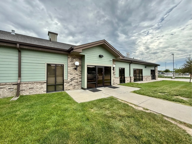

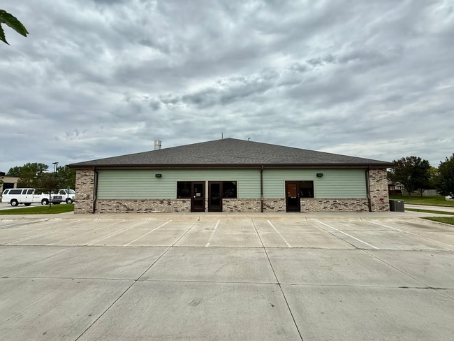
This Property Is For Sale
NEARBY LISTINGS FOR SALE OR LEASE
Property Detail
6704 S 167Th St
Omaha-Council Bluffs, NE-IA
Vintage Oaks
0322-2032-24
VINTAGE OAKS REPLAT 43 LOT 2 BLOCK 0 LT 2 0.960 AC
Daycare
Douglas
X
Nebraska
31153C0035H
2
2024
0.96 AC
2025
Southwest Omaha
007461
Omaha/Council Bluffs
9,876 SF
DEMOGRAPHICS near 6704 S 167Th St
1 Mile
3 Mile
5 Mile
2024 Total Population
14,811
87,420
161,084
2029 Population
15,213
90,718
166,498
Pop Growth 2024-2029
+ 2.71%
+ 3.77%
+ 3.36%
Average Age
38
37
38
2024 Total Households
4,916
31,147
59,395
HH Growth 2024-2029
+ 2.91%
+ 3.75%
+ 3.33%
Median Household Inc
$134,120
$108,934
$104,891
Avg Household Size
3.00
2.80
2.70
2024 Avg HH Vehicles
2.00
2.00
2.00
Median Home Value
$291,238
$268,560
$275,439
Median Year Built
2000
1999
1995
Nearby Places
Map Layers
Map Styles
 Street
 Aerial
- Restaurants
- Banks
- Shops
- Fitness
- Groceries
PUBLIC TRANSPORTATION
AIRPORT
Eppley Airfield
DRIVE
WALK
Distance
Eppley Airfield
34 min
21.2 mi
Lincoln
DRIVE
WALK
Distance
Lincoln
53 min
45.3 mi
Nearby Properties
Address
Land Use
TOTAL SIZE
Lot Size
Zoning
Address
Land Use
TOTAL SIZE
Lot Size
Zoning
72.91 AC
Address
Land Use
TOTAL SIZE
Lot Size
Zoning
315,685 SF
21.57 AC
RG10
Address
Land Use
TOTAL SIZE
Lot Size
Zoning
56,174 SF
8.65 AC
Address
Land Use
TOTAL SIZE
Lot Size
Zoning
369,614 SF
18.03 AC
CC
Address
Land Use
TOTAL SIZE
Lot Size
Zoning
299,172 SF
13.80 AC
R7
Address
Land Use
TOTAL SIZE
Lot Size
Zoning
264,001 SF
10.33 AC
Address
Land Use
TOTAL SIZE
Lot Size
Zoning
294,334 SF
19.14 AC
R6
Address
Land Use
TOTAL SIZE
Lot Size
Zoning
274,072 SF
12.06 AC
Address
Land Use
TOTAL SIZE
Lot Size
Zoning
268,545 SF
7.53 AC
Address
Land Use
TOTAL SIZE
Lot Size
Zoning
144,271 SF
4.75 AC
Address
Land Use
TOTAL SIZE
Lot Size
Zoning
238,428 SF
18.64 AC
R5
Address
Land Use
TOTAL SIZE
Lot Size
Zoning
201,293 SF
4.71 AC
Address
Land Use
TOTAL SIZE
Lot Size
Zoning
162,717 SF
6.73 AC
R6
Address
Land Use
TOTAL SIZE
Lot Size
Zoning
170,760 SF
10.30 AC
RG10
Address
Land Use
TOTAL SIZE
Lot Size
Zoning
280,482 SF
11.64 AC
R6
Address
Land Use
TOTAL SIZE
Lot Size
Zoning
193,490 SF
9.35 AC
Address
Land Use
TOTAL SIZE
Lot Size
Zoning
168,547 SF
10.57 AC
Address
Land Use
TOTAL SIZE
Lot Size
Zoning
37,295 SF
Address
Land Use
TOTAL SIZE
Lot Size
Zoning
89,181 SF
4.85 AC
Address
Land Use
TOTAL SIZE
Lot Size
Zoning
77,773 SF
6.93 AC
MU
Address
Land Use
TOTAL SIZE
Lot Size
Zoning
88,898 SF
42.80 AC
BG
Address
Land Use
TOTAL SIZE
Lot Size
Zoning
151,960 SF
13.32 AC
Address
Land Use
TOTAL SIZE
Lot Size
Zoning
103,221 SF
4.48 AC
Address
Land Use
TOTAL SIZE
Lot Size
Zoning
28,444 SF
0.85 AC
Address
Land Use
TOTAL SIZE
Lot Size
Zoning
192,778 SF
10.50 AC
R6
Address
Land Use
TOTAL SIZE
Lot Size
Zoning
52,502 SF
3.72 AC
MU
Address
Land Use
TOTAL SIZE
Lot Size
Zoning
138,976 SF
1.93 AC
Address
Land Use
TOTAL SIZE
Lot Size
Zoning
148,541 SF
13.22 AC
I1
Address
Land Use
TOTAL SIZE
Lot Size
Zoning
133,134 SF
6.03 AC
Address
Land Use
TOTAL SIZE
Lot Size
Zoning
13,993 SF
12.17 AC
The World's #1 Commercial Real Estate Marketplace
Connect with us
© 2025 CoStar Group
The information above has been obtained from sources believed reliable. While we do not doubt its accuracy we have not verified it and make no guarantee, warranty or representation about it. It is your responsibility to independently confirm its accuracy and completeness. Any projections, opinions, assumptions, or estimates used are for example only and do not represent the current or future performance of the property. The value of this transaction to you depends on tax and other factors which should be evaluated by your tax, financial, and legal advisors. You and your advisors should conduct a careful, independent investigation of the property to determine to your satisfaction the suitability of the property for your needs.