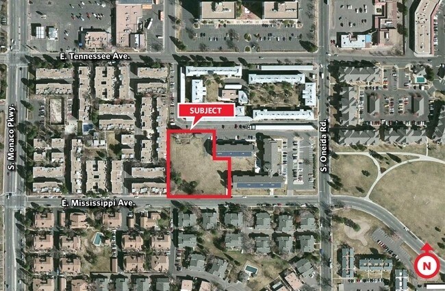
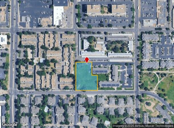
Property Record
6705 E Mississippi Ave, Denver, CO 80224
NEARBY LISTINGS FOR SALE OR LEASE
-
-
-
-
-
-
-
-
-
-
-
No Photo
-
View all Denver listings for sale on LoopNet.com
Property Detail
6705 E Mississippi Ave
6174-00-186
T4 R67 S17 PT SE/4 DIF REC# 2008167467 RCD 12/12/08 DAF COM COM SE/4 SE/4 SW/4 SE/4 TH N 329.94FT W 39FT W 621.21FT S 82.96FT TPOB TH E 133.15FT S 55.61FT E 99.44FT S 161.22FT W
Vacantlandnec
Denver
X
Colorado
0800460208H
1.41 AC
2024
Glendale
2024
Denver
005004
Denver-Aurora-Lakewood, CO
DEMOGRAPHICS near 6705 E Mississippi Ave
1 Mile
3 Mile
5 Mile
2024 Total Population
21,084
198,352
525,690
2029 Population
21,413
201,557
532,389
Pop Growth 2024-2029
+ 1.56%
+ 1.62%
+ 1.27%
Average Age
40
40
39
2024 Total Households
9,758
93,179
243,052
HH Growth 2024-2029
+ 1.44%
+ 1.57%
+ 1.25%
Median Household Inc
$69,085
$74,802
$75,483
Avg Household Size
2.10
2.10
2.10
2024 Avg HH Vehicles
2.00
2.00
2.00
Median Home Value
$458,770
$626,345
$594,396
Median Year Built
1976
1978
1974
Nearby Places
Map Layers
Map Styles
 Street
 Aerial
- Restaurants
- Banks
- Shops
- Fitness
- Groceries
PUBLIC TRANSPORTATION
COMMUTER RAIL
Central Park Station Track 1 (Union Station to Denver Airport Station - Regional Transportation District)
DRIVE
WALK
Distance
Central Park Station Track 1 (Union Station to Denver Airport Station - Regional Transportation District)
14 min
6.6 mi
Central Park Station Track 2 (Union Station to Denver Airport Station - Regional Transportation District)
DRIVE
WALK
Distance
Central Park Station Track 2 (Union Station to Denver Airport Station - Regional Transportation District)
15 min
6.6 mi
AIRPORT
Denver International
DRIVE
WALK
Distance
Denver International
33 min
23.2 mi
Freight Ports
Tulsa Port Of Catoosa
DRIVE
WALK
Distance
Tulsa Port Of Catoosa
729 min
706.0 mi
SALE & LEASE HISTORY
LISTING DATE
SALE/LEASE

Sep 24, 2016
For Sale
Nearby Properties
Address
Land Use
TOTAL SIZE
Lot Size
Zoning
Address
Land Use
TOTAL SIZE
Lot Size
Zoning
856,519 SF
10.04 AC
B-3
Address
Land Use
TOTAL SIZE
Lot Size
Zoning
252,992 SF
11.76 AC
B-3
Address
Land Use
TOTAL SIZE
Lot Size
Zoning
550,760 SF
13.25 AC
CMP-EI
Address
Land Use
TOTAL SIZE
Lot Size
Zoning
197,212 SF
0.56 AC
C-CCN-5
Address
Land Use
TOTAL SIZE
Lot Size
Zoning
543,122 SF
13.43 AC
CMP-EI
Address
Land Use
TOTAL SIZE
Lot Size
Zoning
603,377 SF
9.25 AC
H-1-A
Address
Land Use
TOTAL SIZE
Lot Size
Zoning
152,415 SF
1.09 AC
C-CCN
Address
Land Use
TOTAL SIZE
Lot Size
Zoning
453,280 SF
5.45 AC
B-4
Address
Land Use
TOTAL SIZE
Lot Size
Zoning
416,096 SF
5.20 AC
C-MX-20
Address
Land Use
TOTAL SIZE
Lot Size
Zoning
240,545 SF
2.35 AC
C-MX-20
Address
Land Use
TOTAL SIZE
Lot Size
Zoning
281,456 SF
36.55 AC
R-5
Address
Land Use
TOTAL SIZE
Lot Size
Zoning
97,530 SF
0.43 AC
C-CCN-7
Address
Land Use
TOTAL SIZE
Lot Size
Zoning
185,689 SF
2.50 AC
C-CCN-8
Address
Land Use
TOTAL SIZE
Lot Size
Zoning
83,591 SF
0.42 AC
C-CCN-7
Address
Land Use
TOTAL SIZE
Lot Size
Zoning
174,244 SF
17.26 AC
E-SU-DX
Address
Land Use
TOTAL SIZE
Lot Size
Zoning
169,311 SF
0.47 AC
C-CCN-8
Address
Land Use
TOTAL SIZE
Lot Size
Zoning
178,107 SF
2.28 AC
C-CCN-8
Address
Land Use
TOTAL SIZE
Lot Size
Zoning
191,192 SF
10.16 AC
E-SU-D
Address
Land Use
TOTAL SIZE
Lot Size
Zoning
1,054,198 SF
6.62 AC
PUD
Address
Land Use
TOTAL SIZE
Lot Size
Zoning
379,927 SF
8.06 AC
PUD
Address
Land Use
TOTAL SIZE
Lot Size
Zoning
157,800 SF
2.12 AC
C-CCN-8
Address
Land Use
TOTAL SIZE
Lot Size
Zoning
134,297 SF
1.54 AC
C-MX-5
Address
Land Use
TOTAL SIZE
Lot Size
Zoning
167,621 SF
6.59 AC
E-SU-D
Address
Land Use
TOTAL SIZE
Lot Size
Zoning
77,811 SF
0.28 AC
C-CCN-8
Address
Land Use
TOTAL SIZE
Lot Size
Zoning
153,600 SF
0.48 AC
C-MX-8
Address
Land Use
TOTAL SIZE
Lot Size
Zoning
132,788 SF
1.02 AC
C-MX-5
Address
Land Use
TOTAL SIZE
Lot Size
Zoning
85,381 SF
0.54 AC
C-MX-8
Address
Land Use
TOTAL SIZE
Lot Size
Zoning
104,221 SF
1.41 AC
C-CCN-8
Address
Land Use
TOTAL SIZE
Lot Size
Zoning
93,617 SF
0.49 AC
C-MX-5
Address
Land Use
TOTAL SIZE
Lot Size
Zoning
102,916 SF
1.13 AC
PUD
The World's #1 Commercial Real Estate Marketplace
Connect with us
© 2025 CoStar Group
The information above has been obtained from sources believed reliable. While we do not doubt its accuracy we have not verified it and make no guarantee, warranty or representation about it. It is your responsibility to independently confirm its accuracy and completeness. Any projections, opinions, assumptions, or estimates used are for example only and do not represent the current or future performance of the property. The value of this transaction to you depends on tax and other factors which should be evaluated by your tax, financial, and legal advisors. You and your advisors should conduct a careful, independent investigation of the property to determine to your satisfaction the suitability of the property for your needs.