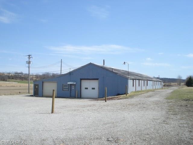
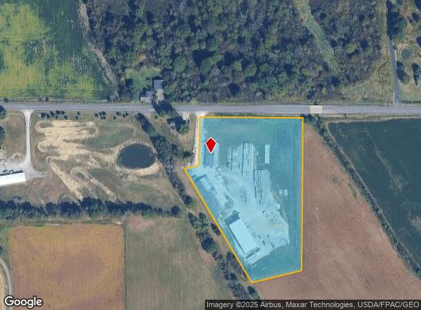
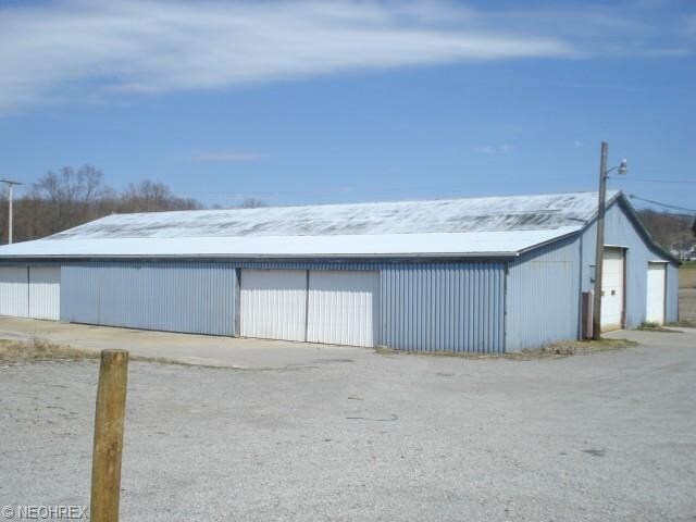
Property Record
6705 W South Range Rd, Greenford, OH 44422
NEARBY LISTINGS FOR SALE OR LEASE
Property Detail
6705 W South Range Rd
Youngstown/Warren/Boardman
Township/Green Sec 23
Youngstown-Warren, OH
SEC 23
09-046-0-011.00-0
Mahoning
Storebuilding
Ohio
2024
23
2024
6.48 AC
812200
Mahoning County
21,194 SF
DEMOGRAPHICS near 6705 W South Range Rd
1 mile
3 mile
5 mile
2024 Total Population
245
2,705
18,925
2029 Population
230
2,582
18,516
Pop Growth 2024-2029
(6.12%)
(4.55%)
(2.16%)
Average Age
44
43
44
2024 Total Households
94
1,036
7,781
HH Growth 2024-2029
(6.38%)
(4.63%)
(2.13%)
Median Household Inc
$94,047
$82,686
$63,754
Avg Household Size
2.60
2.60
2.40
2024 Avg HH Vehicles
3.00
2.00
2.00
Median Home Value
$295,651
$257,904
$170,439
Median Year Built
1972
1972
1961
Nearby Places
Map Layers
Map Styles
 Street
 Aerial
Transit
 Traffic
 Biking
Places
Listings with unknown addresses are not visible on the map
- Restaurants
- Banks
- Shops
- Fitness
- Groceries
PUBLIC TRANSPORTATION
AIRPORT
Akron-Canton Regional
Drive
Walk
Distance
Akron-Canton Regional
64 min
39.1 mi
SALE & LEASE HISTORY
LISTING DATE
SALE/LEASE

Nov 07, 2016
For Sale
Nearby Properties
Address
Land Use
TOTAL SIZE
Lot Size
Zoning
Address
Land Use
TOTAL SIZE
Lot Size
Zoning
195,204 SF
58.85 AC
RR
Address
Land Use
TOTAL SIZE
Lot Size
Zoning
13.36 AC
Address
Land Use
TOTAL SIZE
Lot Size
Zoning
36,007 SF
2.39 AC
GC
Address
Land Use
TOTAL SIZE
Lot Size
Zoning
44,637 SF
65.48 AC
A
Address
Land Use
TOTAL SIZE
Lot Size
Zoning
36,298 SF
6.94 AC
R1
Address
Land Use
TOTAL SIZE
Lot Size
Zoning
17,416 SF
41.24 AC
A
Address
Land Use
TOTAL SIZE
Lot Size
Zoning
1,830 SF
34.79 AC
RR
Address
Land Use
TOTAL SIZE
Lot Size
Zoning
231.76 AC
A
Address
Land Use
TOTAL SIZE
Lot Size
Zoning
10,518 SF
20.56 AC
A
Address
Land Use
TOTAL SIZE
Lot Size
Zoning
Address
Land Use
TOTAL SIZE
Lot Size
Zoning
24,106 SF
5 AC
Address
Land Use
TOTAL SIZE
Lot Size
Zoning
7,158 SF
18.53 AC
A
Address
Land Use
TOTAL SIZE
Lot Size
Zoning
11,339 SF
111.73 AC
A
Address
Land Use
TOTAL SIZE
Lot Size
Zoning
9,802 SF
42.94 AC
A
Address
Land Use
TOTAL SIZE
Lot Size
Zoning
143.99 AC
A
Address
Land Use
TOTAL SIZE
Lot Size
Zoning
4,476 SF
153.68 AC
A
Address
Land Use
TOTAL SIZE
Lot Size
Zoning
4,984 SF
122.02 AC
A
Address
Land Use
TOTAL SIZE
Lot Size
Zoning
7,304 SF
92.50 AC
A
Address
Land Use
TOTAL SIZE
Lot Size
Zoning
3,760 SF
140.28 AC
A
Address
Land Use
TOTAL SIZE
Lot Size
Zoning
10,134 SF
62.46 AC
A
Address
Land Use
TOTAL SIZE
Lot Size
Zoning
7,411 SF
26.10 AC
A
Address
Land Use
TOTAL SIZE
Lot Size
Zoning
10,535 SF
11.99 AC
Address
Land Use
TOTAL SIZE
Lot Size
Zoning
4,608 SF
67.79 AC
A
Address
Land Use
TOTAL SIZE
Lot Size
Zoning
49,867 SF
2.79 AC
B
Address
Land Use
TOTAL SIZE
Lot Size
Zoning
2,652 SF
153.16 AC
A
Address
Land Use
TOTAL SIZE
Lot Size
Zoning
3,840 SF
73.70 AC
A
Address
Land Use
TOTAL SIZE
Lot Size
Zoning
7,641 SF
21.37 AC
A
Address
Land Use
TOTAL SIZE
Lot Size
Zoning
6,404 SF
25.17 AC
A
Address
Land Use
TOTAL SIZE
Lot Size
Zoning
4,769 SF
93.03 AC
A
Address
Land Use
TOTAL SIZE
Lot Size
Zoning
7,760 SF
10.34 AC
A
The World's #1 Commercial Real Estate Marketplace
Connect with us
© 2026 CoStar Group
The information above has been obtained from sources believed reliable. While we do not doubt its accuracy we have not verified it and make no guarantee, warranty or representation about it. It is your responsibility to independently confirm its accuracy and completeness. Any projections, opinions, assumptions, or estimates used are for example only and do not represent the current or future performance of the property. The value of this transaction to you depends on tax and other factors which should be evaluated by your tax, financial, and legal advisors. You and your advisors should conduct a careful, independent investigation of the property to determine to your satisfaction the suitability of the property for your needs.