Property Record
6707 Saint Lukes Church Rd, Barnhart, MO 63012
This Property Is For Sale
NEARBY LISTINGS FOR SALE OR LEASE
Property Detail
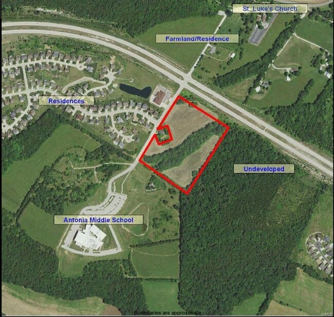
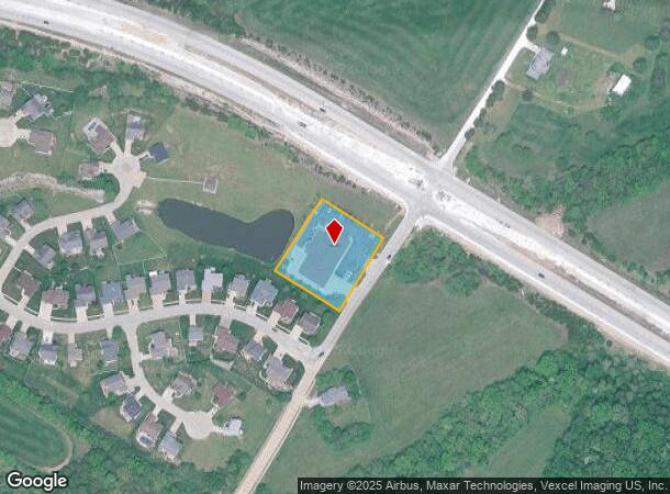
6707 Saint Lukes Church Rd
St. Louis, MO-IL
St Lukes Place
08-5.0-22.0-0-000-013
ST LUKES PLACE LOT 1
Commercialnec
Jefferson
X
Missouri
29099C0227F
1
0
1.25 AC
2025
Jefferson County
700604
St. Louis
1,070 SF
DEMOGRAPHICS near 6707 Saint Lukes Church Rd
1 Mile
3 Mile
5 Mile
2024 Total Population
1,692
18,967
52,261
2029 Population
1,732
19,429
53,817
Pop Growth 2024-2029
+ 2.36%
+ 2.44%
+ 2.98%
Average Age
38
39
39
2024 Total Households
570
6,583
19,191
HH Growth 2024-2029
+ 2.46%
+ 2.58%
+ 3.08%
Median Household Inc
$97,152
$92,088
$78,705
Avg Household Size
2.90
2.80
2.70
2024 Avg HH Vehicles
3.00
2.00
2.00
Median Home Value
$302,047
$253,222
$229,219
Median Year Built
1997
1991
1990
Nearby Places
- Restaurants
- Banks
- Shops
- Fitness
- Groceries
PUBLIC TRANSPORTATION
AIRPORT
St Louis Lambert International
DRIVE
WALK
Distance
St Louis Lambert International
52 min
36.0 mi
Freight Ports
Tulsa Port of Inola
DRIVE
WALK
Distance
Tulsa Port of Inola
416 min
368.6 mi
Nearby Properties
Address
Land Use
TOTAL SIZE
Lot Size
Zoning
Address
Land Use
TOTAL SIZE
Lot Size
Zoning
67,628 SF
9.17 AC
CC2
Address
Land Use
TOTAL SIZE
Lot Size
Zoning
160,840 SF
11.19 AC
PI
Address
Land Use
TOTAL SIZE
Lot Size
Zoning
81,590 SF
5.36 AC
CC2
Address
Land Use
TOTAL SIZE
Lot Size
Zoning
33,802 SF
5.07 AC
CC2
Address
Land Use
TOTAL SIZE
Lot Size
Zoning
7,395 SF
4.75 AC
CC2
Address
Land Use
TOTAL SIZE
Lot Size
Zoning
10,090 SF
410.93 AC
PI
Address
Land Use
TOTAL SIZE
Lot Size
Zoning
15,035 SF
2.06 AC
CC2
Address
Land Use
TOTAL SIZE
Lot Size
Zoning
77,283 SF
111.18 AC
Address
Land Use
TOTAL SIZE
Lot Size
Zoning
17,616 SF
1.73 AC
Address
Land Use
TOTAL SIZE
Lot Size
Zoning
8,365 SF
2.05 AC
Address
Land Use
TOTAL SIZE
Lot Size
Zoning
5,828 SF
0.94 AC
CC2
Address
Land Use
TOTAL SIZE
Lot Size
Zoning
5,286 SF
1.84 AC
PUD
Address
Land Use
TOTAL SIZE
Lot Size
Zoning
60,100 SF
5.42 AC
PI
Address
Land Use
TOTAL SIZE
Lot Size
Zoning
55,224 SF
12.47 AC
PI
Address
Land Use
TOTAL SIZE
Lot Size
Zoning
30,693 SF
4.16 AC
CC2
Address
Land Use
TOTAL SIZE
Lot Size
Zoning
9,696 SF
1.08 AC
Address
Land Use
TOTAL SIZE
Lot Size
Zoning
37,650 SF
5.10 AC
CC2
Address
Land Use
TOTAL SIZE
Lot Size
Zoning
7,500 SF
0.85 AC
Address
Land Use
TOTAL SIZE
Lot Size
Zoning
16,700 SF
1.55 AC
CC2
Address
Land Use
TOTAL SIZE
Lot Size
Zoning
16,000 SF
4.85 AC
PUD
Address
Land Use
TOTAL SIZE
Lot Size
Zoning
1.01 AC
Address
Land Use
TOTAL SIZE
Lot Size
Zoning
12,000 SF
3 AC
PUD
Address
Land Use
TOTAL SIZE
Lot Size
Zoning
1.19 AC
CC2
Address
Land Use
TOTAL SIZE
Lot Size
Zoning
2,371 SF
0.97 AC
CC2
Address
Land Use
TOTAL SIZE
Lot Size
Zoning
2,976 SF
1.03 AC
Address
Land Use
TOTAL SIZE
Lot Size
Zoning
3,402 SF
1.03 AC
Address
Land Use
TOTAL SIZE
Lot Size
Zoning
3,000 SF
8.96 AC
CC2
Address
Land Use
TOTAL SIZE
Lot Size
Zoning
11,830 SF
1.38 AC
Address
Land Use
TOTAL SIZE
Lot Size
Zoning
26,662 SF
1.27 AC
R07
The World's #1 Commercial Real Estate Marketplace
Connect with us
© 2025 CoStar Group
The information above has been obtained from sources believed reliable. While we do not doubt its accuracy we have not verified it and make no guarantee, warranty or representation about it. It is your responsibility to independently confirm its accuracy and completeness. Any projections, opinions, assumptions, or estimates used are for example only and do not represent the current or future performance of the property. The value of this transaction to you depends on tax and other factors which should be evaluated by your tax, financial, and legal advisors. You and your advisors should conduct a careful, independent investigation of the property to determine to your satisfaction the suitability of the property for your needs.