Property Record
6707 State Rd, Cleveland, OH 44134
NEARBY LISTINGS FOR SALE OR LEASE
-
-
View all Cleveland listings for sale on LoopNet.com
Property Detail
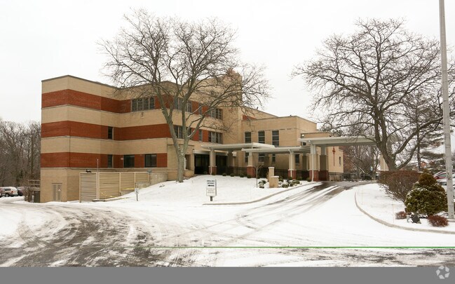
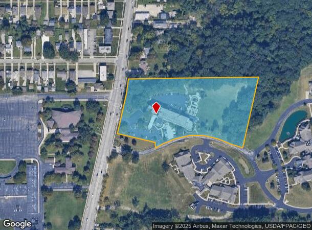
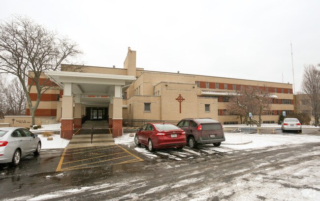
6707 State Rd
Cleveland-Elyria, OH
N Park
451-21-002
ELY O/L 11-12 NP 994.21FT N PARK DR
Charitableorganization
Cuyahoga
X
Ohio
39035C0189E
11,12
2024
6.33 AC
2024
Southwest
177503
Cleveland
52,964 SF
DEMOGRAPHICS near 6707 State Rd
1 mile
3 mile
5 mile
2024 Total Population
11,111
98,037
211,987
2029 Population
10,912
94,924
205,346
Pop Growth 2024-2029
(1.79%)
(3.18%)
(3.13%)
Average Age
43
43
43
2024 Total Households
4,915
42,148
91,565
HH Growth 2024-2029
(1.95%)
(3.36%)
(3.33%)
Median Household Inc
$52,803
$64,306
$62,665
Avg Household Size
2.20
2.20
2.20
2024 Avg HH Vehicles
2.00
2.00
2.00
Median Home Value
$143,626
$158,016
$162,161
Median Year Built
1961
1958
1959
Nearby Places
Map Layers
Map Styles
 Street
 Aerial
Transit
 Traffic
 Biking
Places
Listings with unknown addresses are not visible on the map
- Restaurants
- Banks
- Shops
- Fitness
- Groceries
PUBLIC TRANSPORTATION
COMMUTER RAIL
Drive
Walk
Distance
16 min
6.6 mi
Drive
Walk
Distance
17 min
7.4 mi
AIRPORT
Cleveland-Hopkins International
Drive
Walk
Distance
Cleveland-Hopkins International
24 min
10.5 mi
Akron-Canton Regional
Drive
Walk
Distance
Akron-Canton Regional
61 min
44.2 mi
Nearby Properties
Address
Land Use
TOTAL SIZE
Lot Size
Zoning
Address
Land Use
TOTAL SIZE
Lot Size
Zoning
477,641 SF
14.07 AC
MF-1
Address
Land Use
TOTAL SIZE
Lot Size
Zoning
725,585 SF
76.92 AC
SF-A
Address
Land Use
TOTAL SIZE
Lot Size
Zoning
436,164 SF
20.01 AC
U-5
Address
Land Use
TOTAL SIZE
Lot Size
Zoning
245,255 SF
14 AC
Address
Land Use
TOTAL SIZE
Lot Size
Zoning
238,500 SF
20.31 AC
SC
Address
Land Use
TOTAL SIZE
Lot Size
Zoning
379,061 SF
42.68 AC
Address
Land Use
TOTAL SIZE
Lot Size
Zoning
632,686 SF
16.44 AC
MF-3
Address
Land Use
TOTAL SIZE
Lot Size
Zoning
102,219 SF
14.01 AC
RB
Address
Land Use
TOTAL SIZE
Lot Size
Zoning
162,134 SF
12.24 AC
CG
Address
Land Use
TOTAL SIZE
Lot Size
Zoning
281,600 SF
18.73 AC
SF-A
Address
Land Use
TOTAL SIZE
Lot Size
Zoning
168,322 SF
14.44 AC
Address
Land Use
TOTAL SIZE
Lot Size
Zoning
137,178 SF
8.62 AC
Address
Land Use
TOTAL SIZE
Lot Size
Zoning
440,765 SF
44.35 AC
2F
Address
Land Use
TOTAL SIZE
Lot Size
Zoning
245,255 SF
13.34 AC
Address
Land Use
TOTAL SIZE
Lot Size
Zoning
19.48 AC
U5-A
Address
Land Use
TOTAL SIZE
Lot Size
Zoning
83,375 SF
9.29 AC
MF-1
Address
Land Use
TOTAL SIZE
Lot Size
Zoning
74,731 SF
15.23 AC
A
Address
Land Use
TOTAL SIZE
Lot Size
Zoning
315,434 SF
3.48 AC
A
Address
Land Use
TOTAL SIZE
Lot Size
Zoning
162,134 SF
13.35 AC
CG
Address
Land Use
TOTAL SIZE
Lot Size
Zoning
154,579 SF
18.46 AC
A
Address
Land Use
TOTAL SIZE
Lot Size
Zoning
17,158 SF
20.86 AC
MF-1
Address
Land Use
TOTAL SIZE
Lot Size
Zoning
166,370 SF
8.64 AC
HB
Address
Land Use
TOTAL SIZE
Lot Size
Zoning
258,669 SF
12.80 AC
U-5
Address
Land Use
TOTAL SIZE
Lot Size
Zoning
99,522 SF
52.18 AC
A
Address
Land Use
TOTAL SIZE
Lot Size
Zoning
185,022 SF
14.23 AC
Address
Land Use
TOTAL SIZE
Lot Size
Zoning
114,101 SF
4.40 AC
SF-AA
Address
Land Use
TOTAL SIZE
Lot Size
Zoning
238,500 SF
20.89 AC
SC
Address
Land Use
TOTAL SIZE
Lot Size
Zoning
180,095 SF
26.26 AC
SF-AA
Address
Land Use
TOTAL SIZE
Lot Size
Zoning
126,224 SF
5.31 AC
RB
Address
Land Use
TOTAL SIZE
Lot Size
Zoning
100,047 SF
5.34 AC
SF-A
The World's #1 Commercial Real Estate Marketplace
Connect with us
© 2026 CoStar Group
The information above has been obtained from sources believed reliable. While we do not doubt its accuracy we have not verified it and make no guarantee, warranty or representation about it. It is your responsibility to independently confirm its accuracy and completeness. Any projections, opinions, assumptions, or estimates used are for example only and do not represent the current or future performance of the property. The value of this transaction to you depends on tax and other factors which should be evaluated by your tax, financial, and legal advisors. You and your advisors should conduct a careful, independent investigation of the property to determine to your satisfaction the suitability of the property for your needs.