Property Record
6709 W Pershing Ave, Visalia, CA 93291


Property Detail
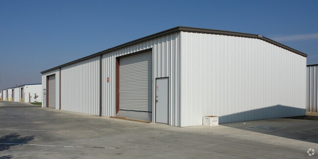
6709 W Pershing Ave
085-520-010-000
LOT 10 US TOWER INDUSTRIAL PARK RM 38-89
Warehouse
Tulare
IL
California
AE The base floodplain where base flood elevations are provided. AE Zones are now used on new format FIRMs instead of A1-A30 Zones.
10
2025
0.75 AC
2025
Northwest Visalia
001005
Visalia/Porterville
12,800 SF
Visalia, CA
NEARBY LISTINGS FOR SALE OR LEASE
DEMOGRAPHICS near 6709 W Pershing Ave
1 mile
3 mile
5 mile
2025 Total Population
7,342
60,994
127,925
2030 Population
7,627
62,541
130,845
Pop Growth 2025-2030
+ 3.88%
+ 2.54%
+ 2.28%
Average Age
38
37
36
2025 Total Households
2,477
20,130
41,538
HH Growth 2025-2030
+ 3.75%
+ 2.51%
+ 2.24%
Median Household Inc
$118,666
$95,623
$84,840
Avg Household Size
2.90
3.00
3.00
2025 Avg HH Vehicles
2.00
2.00
2.00
Median Home Value
$464,817
$409,121
$369,997
Median Year Built
2004
1995
1986
Nearby Places
Map Layers
Map Styles
 Street
 Aerial
Layers
 Traffic
 Biking
Places
Listings with unknown addresses are not visible on the map
- Restaurants
- Banks
- Shops
- Fitness
- Groceries
Nearby Properties
Address
Land Use
TOTAL SIZE
Lot Size
Zoning
Address
Land Use
TOTAL SIZE
Lot Size
Zoning
76.61 AC
Address
Land Use
TOTAL SIZE
Lot Size
Zoning
1,080,308 SF
62.13 AC
Address
Land Use
TOTAL SIZE
Lot Size
Zoning
795,140 SF
64.73 AC
IH
Address
Land Use
TOTAL SIZE
Lot Size
Zoning
300,560 SF
38.07 AC
IL
Address
Land Use
TOTAL SIZE
Lot Size
Zoning
610,344 SF
83.28 AC
IH
Address
Land Use
TOTAL SIZE
Lot Size
Zoning
353,600 SF
18.49 AC
Address
Land Use
TOTAL SIZE
Lot Size
Zoning
500,388 SF
31.90 AC
IH
Address
Land Use
TOTAL SIZE
Lot Size
Zoning
326,700 SF
55.21 AC
IH
Address
Land Use
TOTAL SIZE
Lot Size
Zoning
Address
Land Use
TOTAL SIZE
Lot Size
Zoning
384,146 SF
18.37 AC
IH
Address
Land Use
TOTAL SIZE
Lot Size
Zoning
42,084 SF
9.18 AC
RM2
Address
Land Use
TOTAL SIZE
Lot Size
Zoning
139,410 SF
11.35 AC
CC
Address
Land Use
TOTAL SIZE
Lot Size
Zoning
121,380 SF
24.96 AC
QP
Address
Land Use
TOTAL SIZE
Lot Size
Zoning
6.96 AC
Address
Land Use
TOTAL SIZE
Lot Size
Zoning
178,626 SF
11.39 AC
PA
Address
Land Use
TOTAL SIZE
Lot Size
Zoning
Address
Land Use
TOTAL SIZE
Lot Size
Zoning
156 AC
Address
Land Use
TOTAL SIZE
Lot Size
Zoning
176,582 SF
17.09 AC
M-1
Address
Land Use
TOTAL SIZE
Lot Size
Zoning
19.34 AC
QP
Address
Land Use
TOTAL SIZE
Lot Size
Zoning
549,395 SF
29.81 AC
IL
Address
Land Use
TOTAL SIZE
Lot Size
Zoning
78,751 SF
2.67 AC
R-M-2
Address
Land Use
TOTAL SIZE
Lot Size
Zoning
5.85 AC
RM2
Address
Land Use
TOTAL SIZE
Lot Size
Zoning
82,200 SF
6.29 AC
CSO
Address
Land Use
TOTAL SIZE
Lot Size
Zoning
10.13 AC
Address
Land Use
TOTAL SIZE
Lot Size
Zoning
227,486 SF
9.42 AC
Address
Land Use
TOTAL SIZE
Lot Size
Zoning
The World's #1 Commercial Real Estate Marketplace
Connect with us
© 2026 CoStar Group
The information above has been obtained from sources believed reliable. While we do not doubt its accuracy we have not verified it and make no guarantee, warranty or representation about it. It is your responsibility to independently confirm its accuracy and completeness. Any projections, opinions, assumptions, or estimates used are for example only and do not represent the current or future performance of the property. The value of this transaction to you depends on tax and other factors which should be evaluated by your tax, financial, and legal advisors. You and your advisors should conduct a careful, independent investigation of the property to determine to your satisfaction the suitability of the property for your needs.