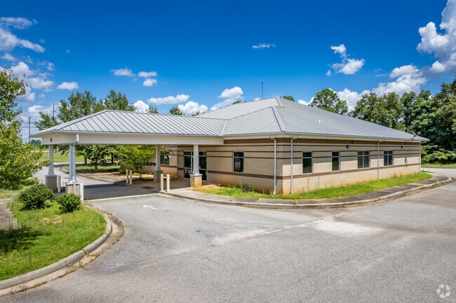
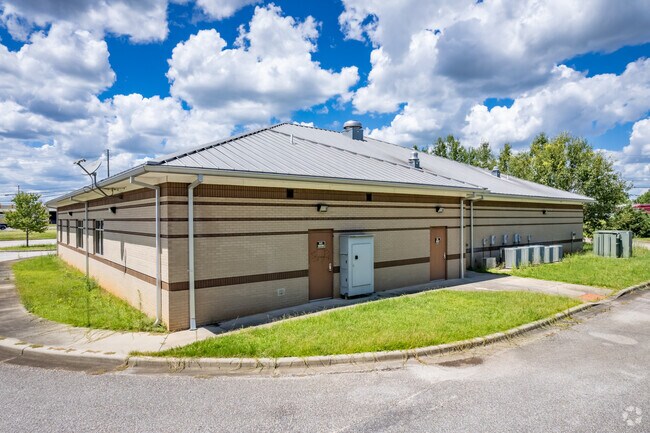
Property Record
671 Ozark Rd, Abbeville, AL 36310


Property Detail
671 Ozark Rd
1107254000001003
BEG SE INT HWY 431 & HWY 27 TH E 182.05'; S 383.23'; W389.46'; NE 279.29'; NE 167.57; TO POB
Medicalbuilding
Henry
B and X Area of moderate flood hazard, usually the area between the limits of the 100-year and 500-year floods.
Alabama
2025
3 AC
2025
Alabama South Area
030200
Other Market Areas
7,776 SF
Dothan, AL
NEARBY LISTINGS FOR SALE OR LEASE
-
-
View all Abbeville listings for sale on LoopNet.com
DEMOGRAPHICS near 671 Ozark Rd
1 mile
3 mile
5 mile
2025 Total Population
159
2,792
3,667
2030 Population
167
2,952
3,871
Pop Growth 2025-2030
+ 5.03%
+ 5.73%
+ 5.56%
Average Age
45
44
44
2025 Total Households
80
1,199
1,563
HH Growth 2025-2030
+ 3.75%
+ 5.42%
+ 5.18%
Median Household Inc
$52,500
$39,910
$41,465
Avg Household Size
2.00
2.20
2.20
2025 Avg HH Vehicles
1.00
2.00
2.00
Median Home Value
$154,761
$108,845
$107,584
Median Year Built
1969
1972
1975
Nearby Places
Map Layers
Map Styles
 Street
 Aerial
Layers
 Traffic
 Biking
Places
Listings with unknown addresses are not visible on the map
- Restaurants
- Banks
- Shops
- Fitness
- Groceries
PUBLIC TRANSPORTATION
AIRPORT
Dothan Regional
Drive
Walk
Distance
Dothan Regional
39 min
23.4 mi
Nearby Properties
Address
Land Use
TOTAL SIZE
Lot Size
Zoning
Address
Land Use
TOTAL SIZE
Lot Size
Zoning
6,676 SF
7 AC
Address
Land Use
TOTAL SIZE
Lot Size
Zoning
24,827 SF
0.85 AC
Address
Land Use
TOTAL SIZE
Lot Size
Zoning
Address
Land Use
TOTAL SIZE
Lot Size
Zoning
1,336 SF
7 AC
Address
Land Use
TOTAL SIZE
Lot Size
Zoning
52,295 SF
2 AC
Address
Land Use
TOTAL SIZE
Lot Size
Zoning
11,800 SF
2 AC
Address
Land Use
TOTAL SIZE
Lot Size
Zoning
Address
Land Use
TOTAL SIZE
Lot Size
Zoning
6,402 SF
0.43 AC
Address
Land Use
TOTAL SIZE
Lot Size
Zoning
9,035 SF
6 AC
Address
Land Use
TOTAL SIZE
Lot Size
Zoning
9,624 SF
0.38 AC
Address
Land Use
TOTAL SIZE
Lot Size
Zoning
54,094 SF
5 AC
Address
Land Use
TOTAL SIZE
Lot Size
Zoning
13,728 SF
1.21 AC
Address
Land Use
TOTAL SIZE
Lot Size
Zoning
4,320 SF
1 AC
Address
Land Use
TOTAL SIZE
Lot Size
Zoning
7,537 SF
1.41 AC
Address
Land Use
TOTAL SIZE
Lot Size
Zoning
Address
Land Use
TOTAL SIZE
Lot Size
Zoning
7,814 SF
3 AC
Address
Land Use
TOTAL SIZE
Lot Size
Zoning
32,204 SF
5 AC
Address
Land Use
TOTAL SIZE
Lot Size
Zoning
4.65 AC
Address
Land Use
TOTAL SIZE
Lot Size
Zoning
984 SF
124 AC
Address
Land Use
TOTAL SIZE
Lot Size
Zoning
8,970 SF
0.71 AC
Address
Land Use
TOTAL SIZE
Lot Size
Zoning
Address
Land Use
TOTAL SIZE
Lot Size
Zoning
17,054 SF
1 AC
Address
Land Use
TOTAL SIZE
Lot Size
Zoning
7,056 SF
0.92 AC
Address
Land Use
TOTAL SIZE
Lot Size
Zoning
205 AC
Address
Land Use
TOTAL SIZE
Lot Size
Zoning
298 AC
Address
Land Use
TOTAL SIZE
Lot Size
Zoning
Address
Land Use
TOTAL SIZE
Lot Size
Zoning
3,334 SF
1.49 AC
Address
Land Use
TOTAL SIZE
Lot Size
Zoning
7,399 SF
2 AC
Address
Land Use
TOTAL SIZE
Lot Size
Zoning
9,240 SF
1.22 AC
The World's #1 Commercial Real Estate Marketplace
Connect with us
© 2026 CoStar Group
The information above has been obtained from sources believed reliable. While we do not doubt its accuracy we have not verified it and make no guarantee, warranty or representation about it. It is your responsibility to independently confirm its accuracy and completeness. Any projections, opinions, assumptions, or estimates used are for example only and do not represent the current or future performance of the property. The value of this transaction to you depends on tax and other factors which should be evaluated by your tax, financial, and legal advisors. You and your advisors should conduct a careful, independent investigation of the property to determine to your satisfaction the suitability of the property for your needs.