Property Record
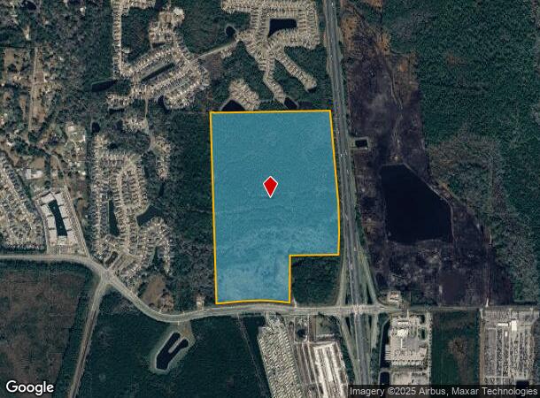
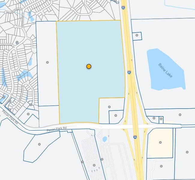
671 Pecan Park Rd, Jacksonville, FL 32218

This Property Is For Sale
NEARBY LISTINGS FOR SALE OR LEASE
Property Detail
671 Pecan Park Rd
Jacksonville, FL
Tisons S/D Pt Seton Grant
108115-0000
1-150 40-1N-27E 9.71 TISONS S/D OF CHARLES SETON GRANT PT LOT 6 RECD O/R 19889-1601 (EX PT RECD O/R 21291-94) LYING N RW RECD O/R 17503-2056, LYING W VISTA CREEK AVE
Commercialacreage
Duval
X
Florida
12031C0045J
6
2024
9.72 AC
2025
Northeast Jacksonville
010308
Jacksonville (Florida)
576 SF
DEMOGRAPHICS near 671 Pecan Park Rd
1 Mile
3 Mile
5 Mile
2024 Total Population
2,404
13,932
38,151
2029 Population
2,484
14,758
40,414
Pop Growth 2024-2029
+ 3.33%
+ 5.93%
+ 5.93%
Average Age
38
37
38
2024 Total Households
737
4,999
14,183
HH Growth 2024-2029
+ 3.12%
+ 6.34%
+ 6.31%
Median Household Inc
$67,414
$80,577
$72,569
Avg Household Size
2.80
2.70
2.60
2024 Avg HH Vehicles
2.00
2.00
2.00
Median Home Value
$265,430
$261,730
$260,782
Median Year Built
2007
2008
2004
Nearby Places
Map Layers
Map Styles
 Street
 Aerial
- Restaurants
- Banks
- Shops
- Fitness
- Groceries
PUBLIC TRANSPORTATION
AIRPORT
Jacksonville International
DRIVE
WALK
Distance
Jacksonville International
10 min
5.8 mi
Freight Ports
Jacksonville Port
DRIVE
WALK
Distance
Jacksonville Port
20 min
15.2 mi
Nearby Properties
Address
Land Use
TOTAL SIZE
Lot Size
Zoning
Address
Land Use
TOTAL SIZE
Lot Size
Zoning
226,421 SF
1.89 AC
PUD
Address
Land Use
TOTAL SIZE
Lot Size
Zoning
189,895 SF
35.11 AC
PUD
Address
Land Use
TOTAL SIZE
Lot Size
Zoning
240,988 SF
18.11 AC
PUD
Address
Land Use
TOTAL SIZE
Lot Size
Zoning
201,630 SF
21.59 AC
PUD
Address
Land Use
TOTAL SIZE
Lot Size
Zoning
210,341 SF
8.84 AC
PUD
Address
Land Use
TOTAL SIZE
Lot Size
Zoning
640,660 SF
28.30 AC
PUD
Address
Land Use
TOTAL SIZE
Lot Size
Zoning
197,526 SF
11.98 AC
PUD
Address
Land Use
TOTAL SIZE
Lot Size
Zoning
117,647 SF
10.17 AC
PUD
Address
Land Use
TOTAL SIZE
Lot Size
Zoning
48,309 SF
4.03 AC
CCG-1
Address
Land Use
TOTAL SIZE
Lot Size
Zoning
90,363 SF
11.12 AC
PUD
Address
Land Use
TOTAL SIZE
Lot Size
Zoning
110,968 SF
5.75 AC
PUD
Address
Land Use
TOTAL SIZE
Lot Size
Zoning
28,653 SF
2.89 AC
PUD
Address
Land Use
TOTAL SIZE
Lot Size
Zoning
86,637 SF
8.09 AC
CCG-1
Address
Land Use
TOTAL SIZE
Lot Size
Zoning
36,288 SF
2.24 AC
CCG-1
Address
Land Use
TOTAL SIZE
Lot Size
Zoning
28,892 SF
3.39 AC
PUD
Address
Land Use
TOTAL SIZE
Lot Size
Zoning
125,300 SF
13.34 AC
PUD
Address
Land Use
TOTAL SIZE
Lot Size
Zoning
32,744 SF
3.68 AC
CCG-1
Address
Land Use
TOTAL SIZE
Lot Size
Zoning
93.72 AC
PUD
Address
Land Use
TOTAL SIZE
Lot Size
Zoning
35,589 SF
2.82 AC
PUD
Address
Land Use
TOTAL SIZE
Lot Size
Zoning
39,102 SF
2.88 AC
PUD
Address
Land Use
TOTAL SIZE
Lot Size
Zoning
32,944 SF
3.21 AC
PUD
Address
Land Use
TOTAL SIZE
Lot Size
Zoning
9,750 SF
71.20 AC
IL
Address
Land Use
TOTAL SIZE
Lot Size
Zoning
24.37 AC
PUD
Address
Land Use
TOTAL SIZE
Lot Size
Zoning
33,578 SF
2.97 AC
CCG-1
Address
Land Use
TOTAL SIZE
Lot Size
Zoning
27,096 SF
2.48 AC
CCG-1
Address
Land Use
TOTAL SIZE
Lot Size
Zoning
22,607 SF
1.95 AC
PUD
Address
Land Use
TOTAL SIZE
Lot Size
Zoning
283,827 SF
98.64 AC
IL
Address
Land Use
TOTAL SIZE
Lot Size
Zoning
74,432 SF
6.42 AC
CCG-1
Address
Land Use
TOTAL SIZE
Lot Size
Zoning
56,488 SF
4.18 AC
PUD
Address
Land Use
TOTAL SIZE
Lot Size
Zoning
322,359 SF
14.85 AC
CCG-1
The World's #1 Commercial Real Estate Marketplace
Connect with us
© 2025 CoStar Group
The information above has been obtained from sources believed reliable. While we do not doubt its accuracy we have not verified it and make no guarantee, warranty or representation about it. It is your responsibility to independently confirm its accuracy and completeness. Any projections, opinions, assumptions, or estimates used are for example only and do not represent the current or future performance of the property. The value of this transaction to you depends on tax and other factors which should be evaluated by your tax, financial, and legal advisors. You and your advisors should conduct a careful, independent investigation of the property to determine to your satisfaction the suitability of the property for your needs.