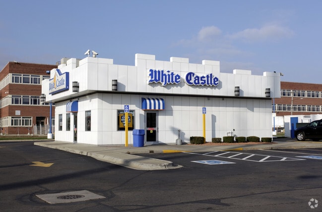
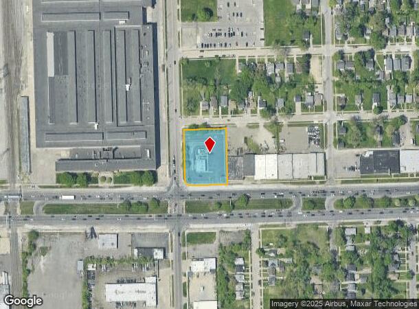
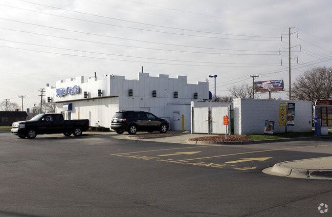
Property Record
6711 E 8 Mile Rd, Warren, MI 48091
NEARBY LISTINGS FOR SALE OR LEASE
Property Detail
6711 E 8 Mile Rd
Detroit-Warren-Dearborn, MI
Kehoes North Van Dyke Sub
12-13-33-457-018
LOT 161-166
Restaurantdrivein
Macomb
X
Michigan
26163C0125E
146-160
2024
1.12 AC
2025
Macomb West
263800
Detroit
1,575 SF
DEMOGRAPHICS near 6711 E 8 Mile Rd
1 Mile
3 Mile
5 Mile
2024 Total Population
14,253
132,295
373,361
2029 Population
14,179
132,225
372,903
Pop Growth 2024-2029
(0.52%)
(0.05%)
(0.12%)
Average Age
36
37
38
2024 Total Households
5,162
49,473
142,872
HH Growth 2024-2029
(0.58%)
(0.10%)
(0.07%)
Median Household Inc
$39,576
$40,103
$43,629
Avg Household Size
2.70
2.60
2.50
2024 Avg HH Vehicles
1.00
1.00
1.00
Median Home Value
$57,747
$75,417
$99,978
Median Year Built
1953
1954
1954
Nearby Places
Map Layers
Map Styles
 Street
 Aerial
- Restaurants
- Banks
- Shops
- Fitness
- Groceries
PUBLIC TRANSPORTATION
COMMUTER RAIL
Royal Oak Amtrak (Wolverine - Amtrak)
DRIVE
WALK
Distance
Royal Oak Amtrak (Wolverine - Amtrak)
15 min
8.1 mi
Detroit (Wolverine - Amtrak)
DRIVE
WALK
Distance
Detroit (Wolverine - Amtrak)
16 min
9.6 mi
AIRPORT
Windsor International
DRIVE
WALK
Distance
Windsor International
40 min
21.5 mi
Detroit Metro Wayne County
DRIVE
WALK
Distance
Detroit Metro Wayne County
45 min
31.1 mi
Freight Ports
Port of Toledo
DRIVE
WALK
Distance
Port of Toledo
91 min
72.0 mi
Nearby Properties
Address
Land Use
TOTAL SIZE
Lot Size
Zoning
Address
Land Use
TOTAL SIZE
Lot Size
Zoning
419,600 SF
Address
Land Use
TOTAL SIZE
Lot Size
Zoning
3,327,621 SF
130.89 AC
M-4
Address
Land Use
TOTAL SIZE
Lot Size
Zoning
450,958 SF
Address
Land Use
TOTAL SIZE
Lot Size
Zoning
1,784,888 SF
58.32 AC
M-4
Address
Land Use
TOTAL SIZE
Lot Size
Zoning
306,345 SF
Address
Land Use
TOTAL SIZE
Lot Size
Zoning
455,425 SF
Address
Land Use
TOTAL SIZE
Lot Size
Zoning
401,671 SF
19.40 AC
MZ
Address
Land Use
TOTAL SIZE
Lot Size
Zoning
198,064 SF
11.11 AC
MZ
Address
Land Use
TOTAL SIZE
Lot Size
Zoning
1,261,658 SF
71.94 AC
M-2
Address
Land Use
TOTAL SIZE
Lot Size
Zoning
Address
Land Use
TOTAL SIZE
Lot Size
Zoning
362,895 SF
14.85 AC
M-2
Address
Land Use
TOTAL SIZE
Lot Size
Zoning
259,959 SF
27.39 AC
MZ
Address
Land Use
TOTAL SIZE
Lot Size
Zoning
1,094,075 SF
58.76 AC
M-4
Address
Land Use
TOTAL SIZE
Lot Size
Zoning
303,615 SF
22.07 AC
MZ
Address
Land Use
TOTAL SIZE
Lot Size
Zoning
426,764 SF
38.46 AC
R-M
Address
Land Use
TOTAL SIZE
Lot Size
Zoning
197,670 SF
42.84 AC
M4
Address
Land Use
TOTAL SIZE
Lot Size
Zoning
166,064 SF
6.33 AC
M-3
Address
Land Use
TOTAL SIZE
Lot Size
Zoning
123,844 SF
1.81 AC
R2
Address
Land Use
TOTAL SIZE
Lot Size
Zoning
156,250 SF
8.79 AC
B4
Address
Land Use
TOTAL SIZE
Lot Size
Zoning
168,200 SF
12.08 AC
R-3
Address
Land Use
TOTAL SIZE
Lot Size
Zoning
116,060 SF
6.95 AC
R2
Address
Land Use
TOTAL SIZE
Lot Size
Zoning
410,359 SF
27.52 AC
M4
Address
Land Use
TOTAL SIZE
Lot Size
Zoning
125,055 SF
7.74 AC
MZ
Address
Land Use
TOTAL SIZE
Lot Size
Zoning
81,072 SF
5.67 AC
M-4
Address
Land Use
TOTAL SIZE
Lot Size
Zoning
180,834 SF
17.97 AC
M-3
Address
Land Use
TOTAL SIZE
Lot Size
Zoning
40,951 SF
42.61 AC
M-2
Address
Land Use
TOTAL SIZE
Lot Size
Zoning
251,056 SF
17.80 AC
MZ
Address
Land Use
TOTAL SIZE
Lot Size
Zoning
87,890 SF
Address
Land Use
TOTAL SIZE
Lot Size
Zoning
641,836 SF
20.69 AC
M4
Address
Land Use
TOTAL SIZE
Lot Size
Zoning
182,800 SF
7.86 AC
M-3
The World's #1 Commercial Real Estate Marketplace
Connect with us
© 2026 CoStar Group
The information above has been obtained from sources believed reliable. While we do not doubt its accuracy we have not verified it and make no guarantee, warranty or representation about it. It is your responsibility to independently confirm its accuracy and completeness. Any projections, opinions, assumptions, or estimates used are for example only and do not represent the current or future performance of the property. The value of this transaction to you depends on tax and other factors which should be evaluated by your tax, financial, and legal advisors. You and your advisors should conduct a careful, independent investigation of the property to determine to your satisfaction the suitability of the property for your needs.