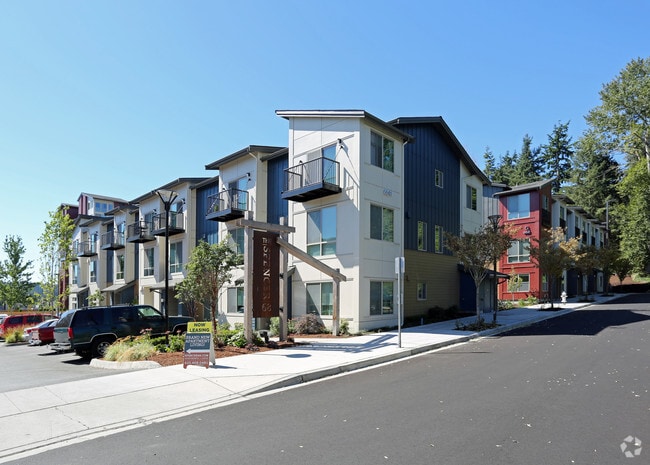
Property Record
6711 Ne 182Nd St, Kenmore, WA 98028


NEARBY LISTINGS FOR SALE OR LEASE
Property Detail
6711 Ne 182Nd St
Seattle/Puget Sound
Spencer68 Bsp
Seattle-Tacoma-Bellevue, WA
SPENCER68 BSP REC VOL 265 PGS 82-84 (REC #20140520000886) POR TAXABLE PER RCW 84.14 MFTE (MULTIFAMILY TAX EXEMPTION) PROGRAM
791400-0010
King
Apartment
Washington
2025
1
2024
2.35 AC
021600
Central Kenmore
115,126 SF
DEMOGRAPHICS near 6711 Ne 182Nd St
1 Mile
3 Mile
5 Mile
2024 Total Population
12,655
106,239
349,689
2029 Population
12,741
107,965
357,977
Pop Growth 2024-2029
+ 0.68%
+ 1.62%
+ 2.37%
Average Age
41
41
40
2024 Total Households
5,252
42,180
139,999
HH Growth 2024-2029
+ 0.55%
+ 1.56%
+ 2.36%
Median Household Inc
$113,413
$121,208
$110,012
Avg Household Size
2.40
2.50
2.40
2024 Avg HH Vehicles
2.00
2.00
2.00
Median Home Value
$777,005
$780,440
$760,525
Median Year Built
1983
1982
1981
Nearby Places
Map Layers
Map Styles
 Street
 Aerial
- Restaurants
- Banks
- Shops
- Fitness
- Groceries
PUBLIC TRANSPORTATION
COMMUTER RAIL
Edmonds Station (Sounder South Line - Central Puget Sound Regional Transit Authority Rail (Link Light Rail/Sounder))
DRIVE
WALK
Distance
Edmonds Station (Sounder South Line - Central Puget Sound Regional Transit Authority Rail (Link Light Rail/Sounder))
19 min
9.0 mi
AIRPORT
Seattle Paine Field International
DRIVE
WALK
Distance
Seattle Paine Field International
26 min
13.2 mi
Seattle-Tacoma International
DRIVE
WALK
Distance
Seattle-Tacoma International
44 min
27.9 mi
Freight Ports
Port of Seattle
DRIVE
WALK
Distance
Port of Seattle
31 min
18.4 mi
Nearby Properties
Address
Land Use
TOTAL SIZE
Lot Size
Zoning
Address
Land Use
TOTAL SIZE
Lot Size
Zoning
50,400 SF
123.66 AC
C
Address
Land Use
TOTAL SIZE
Lot Size
Zoning
444,231 SF
31.50 AC
SDD/R
Address
Land Use
TOTAL SIZE
Lot Size
Zoning
2.60 AC
DN
Address
Land Use
TOTAL SIZE
Lot Size
Zoning
194,388 SF
1.65 AC
DC
Address
Land Use
TOTAL SIZE
Lot Size
Zoning
170,520 SF
1.92 AC
DN
Address
Land Use
TOTAL SIZE
Lot Size
Zoning
217,877 SF
17.03 AC
R 2,800
Address
Land Use
TOTAL SIZE
Lot Size
Zoning
75,661 SF
30.54 AC
R 8400
Address
Land Use
TOTAL SIZE
Lot Size
Zoning
131,236 SF
19.14 AC
R6
Address
Land Use
TOTAL SIZE
Lot Size
Zoning
184,576 SF
9.56 AC
RMA 1.8
Address
Land Use
TOTAL SIZE
Lot Size
Zoning
122,766 SF
2 AC
GDC
Address
Land Use
TOTAL SIZE
Lot Size
Zoning
204,428 SF
34.65 AC
R 9600
Address
Land Use
TOTAL SIZE
Lot Size
Zoning
119,470 SF
1.56 AC
DN
Address
Land Use
TOTAL SIZE
Lot Size
Zoning
114,513 SF
2.35 AC
GDC
Address
Land Use
TOTAL SIZE
Lot Size
Zoning
113,880 SF
1.56 AC
GDC
Address
Land Use
TOTAL SIZE
Lot Size
Zoning
177,990 SF
50.72 AC
PUBLIC/SEM
Address
Land Use
TOTAL SIZE
Lot Size
Zoning
194,954 SF
49.73 AC
PUBLIC/SEM
Address
Land Use
TOTAL SIZE
Lot Size
Zoning
120,420 SF
0.94 AC
DN
Address
Land Use
TOTAL SIZE
Lot Size
Zoning
220,968 SF
16.46 AC
TC
Address
Land Use
TOTAL SIZE
Lot Size
Zoning
236,309 SF
43.88 AC
R6
Address
Land Use
TOTAL SIZE
Lot Size
Zoning
95,892 SF
1.05 AC
DT
Address
Land Use
TOTAL SIZE
Lot Size
Zoning
141,044 SF
5.46 AC
R 9600, SS
Address
Land Use
TOTAL SIZE
Lot Size
Zoning
308.56 AC
P
Address
Land Use
TOTAL SIZE
Lot Size
Zoning
158,688 SF
5.78 AC
RM 900
Address
Land Use
TOTAL SIZE
Lot Size
Zoning
134,964 SF
8.87 AC
R18
Address
Land Use
TOTAL SIZE
Lot Size
Zoning
41.24 AC
R 9,600
Address
Land Use
TOTAL SIZE
Lot Size
Zoning
75,644 SF
5.50 AC
P
Address
Land Use
TOTAL SIZE
Lot Size
Zoning
85,522 SF
0.53 AC
DC
Address
Land Use
TOTAL SIZE
Lot Size
Zoning
142,992 SF
3.16 AC
R 2800, OP
Address
Land Use
TOTAL SIZE
Lot Size
Zoning
88,090 SF
1.33 AC
DN
Address
Land Use
TOTAL SIZE
Lot Size
Zoning
78,866 SF
1.10 AC
DC
The World's #1 Commercial Real Estate Marketplace
Connect with us
© 2025 CoStar Group
The information above has been obtained from sources believed reliable. While we do not doubt its accuracy we have not verified it and make no guarantee, warranty or representation about it. It is your responsibility to independently confirm its accuracy and completeness. Any projections, opinions, assumptions, or estimates used are for example only and do not represent the current or future performance of the property. The value of this transaction to you depends on tax and other factors which should be evaluated by your tax, financial, and legal advisors. You and your advisors should conduct a careful, independent investigation of the property to determine to your satisfaction the suitability of the property for your needs.