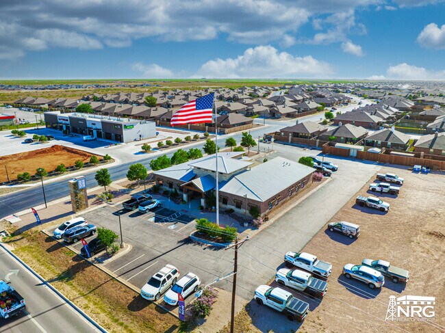
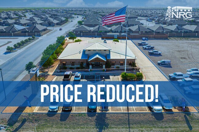
Property Record
6718 N State Highway 349, Midland, TX 79705

Property Detail
6718 N State Highway 349
Midland, TX
ACRES: 0.783 BLK: 001 LOT: 001 ADDN: LONE STAR BUSINESS PARK
R000212-644
MIDLAND
Realpropertynec
Texas
2025
1
2025
0.78 AC
010123
Midland & Odessa
17,900 SF
Other Market Areas
NEARBY LISTINGS FOR SALE OR LEASE
-
-
View all Midland listings for sale on LoopNet.com
DEMOGRAPHICS near 6718 N State Highway 349
1 mile
3 mile
5 mile
2024 Total Population
3,253
18,435
62,021
2029 Population
3,679
20,489
65,166
Pop Growth 2024-2029
+ 13.10%
+ 11.14%
+ 5.07%
Average Age
29
32
35
2024 Total Households
1,112
6,633
23,115
HH Growth 2024-2029
+ 13.31%
+ 11.25%
+ 5.23%
Median Household Inc
$97,336
$101,254
$94,462
Avg Household Size
2.90
2.70
2.60
2024 Avg HH Vehicles
2.00
2.00
2.00
Median Home Value
$308,055
$338,098
$311,299
Median Year Built
2011
2010
1988
Nearby Places
Map Layers
Map Styles
 Street
 Aerial
Transit
 Traffic
 Biking
Places
Listings with unknown addresses are not visible on the map
- Restaurants
- Banks
- Shops
- Fitness
- Groceries
PUBLIC TRANSPORTATION
AIRPORT
Midland International Air And Space Port
Drive
Walk
Distance
Midland International Air And Space Port
23 min
17.1 mi
SALE & LEASE HISTORY
LISTING DATE
SALE/LEASE

Jul 15, 2024
For Sale
Nearby Properties
Address
Land Use
TOTAL SIZE
Lot Size
Zoning
Address
Land Use
TOTAL SIZE
Lot Size
Zoning
9,988 SF
17.46 AC
Address
Land Use
TOTAL SIZE
Lot Size
Zoning
8,290 SF
12.79 AC
Address
Land Use
TOTAL SIZE
Lot Size
Zoning
218,400 SF
14.12 AC
Address
Land Use
TOTAL SIZE
Lot Size
Zoning
5,178 SF
16.66 AC
PDOC
Address
Land Use
TOTAL SIZE
Lot Size
Zoning
904 SF
11.34 AC
MF1
Address
Land Use
TOTAL SIZE
Lot Size
Zoning
1,980 SF
10.25 AC
MF1
Address
Land Use
TOTAL SIZE
Lot Size
Zoning
352 SF
4.50 AC
O2
Address
Land Use
TOTAL SIZE
Lot Size
Zoning
16,016 SF
2 AC
Address
Land Use
TOTAL SIZE
Lot Size
Zoning
23,136 SF
6.61 AC
MF1
Address
Land Use
TOTAL SIZE
Lot Size
Zoning
22,560 SF
3.22 AC
Address
Land Use
TOTAL SIZE
Lot Size
Zoning
34,040 SF
576.92 AC
PDRC
Address
Land Use
TOTAL SIZE
Lot Size
Zoning
13,875 SF
3.06 AC
Address
Land Use
TOTAL SIZE
Lot Size
Zoning
13,104 SF
10.47 AC
PDSC
Address
Land Use
TOTAL SIZE
Lot Size
Zoning
4,060 SF
3.43 AC
PDHD
Address
Land Use
TOTAL SIZE
Lot Size
Zoning
2,415 SF
3.61 AC
Address
Land Use
TOTAL SIZE
Lot Size
Zoning
2,397 SF
2.30 AC
LR1
Address
Land Use
TOTAL SIZE
Lot Size
Zoning
72,360 SF
10.56 AC
Address
Land Use
TOTAL SIZE
Lot Size
Zoning
23,065 SF
4.91 AC
PDSC
Address
Land Use
TOTAL SIZE
Lot Size
Zoning
831 SF
8.42 AC
AE
Address
Land Use
TOTAL SIZE
Lot Size
Zoning
3,000 SF
2.75 AC
Address
Land Use
TOTAL SIZE
Lot Size
Zoning
36,998 SF
1.51 AC
O1
Address
Land Use
TOTAL SIZE
Lot Size
Zoning
8,008 SF
1.50 AC
PDOC
Address
Land Use
TOTAL SIZE
Lot Size
Zoning
9,543 SF
1.96 AC
PDOC
Address
Land Use
TOTAL SIZE
Lot Size
Zoning
7,429 SF
1.54 AC
Address
Land Use
TOTAL SIZE
Lot Size
Zoning
875 SF
3.22 AC
PDID
Address
Land Use
TOTAL SIZE
Lot Size
Zoning
125.42 AC
AE
Address
Land Use
TOTAL SIZE
Lot Size
Zoning
3,600 SF
3.99 AC
PDOC
Address
Land Use
TOTAL SIZE
Lot Size
Zoning
1,156 SF
3.95 AC
The World's #1 Commercial Real Estate Marketplace
Connect with us
© 2026 CoStar Group
The information above has been obtained from sources believed reliable. While we do not doubt its accuracy we have not verified it and make no guarantee, warranty or representation about it. It is your responsibility to independently confirm its accuracy and completeness. Any projections, opinions, assumptions, or estimates used are for example only and do not represent the current or future performance of the property. The value of this transaction to you depends on tax and other factors which should be evaluated by your tax, financial, and legal advisors. You and your advisors should conduct a careful, independent investigation of the property to determine to your satisfaction the suitability of the property for your needs.