Property Record
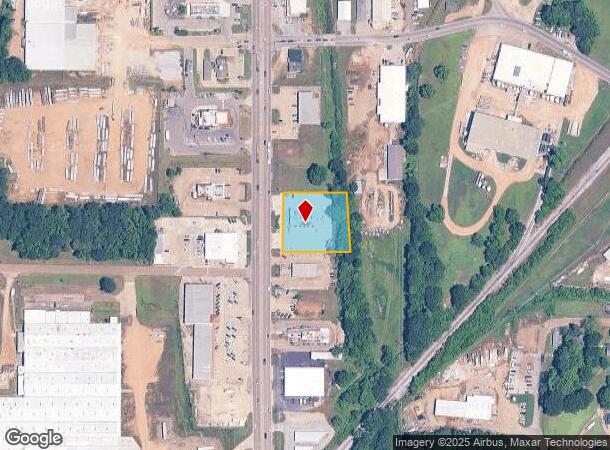
6720 Highway 45 Alt S, West Point, MS 39773
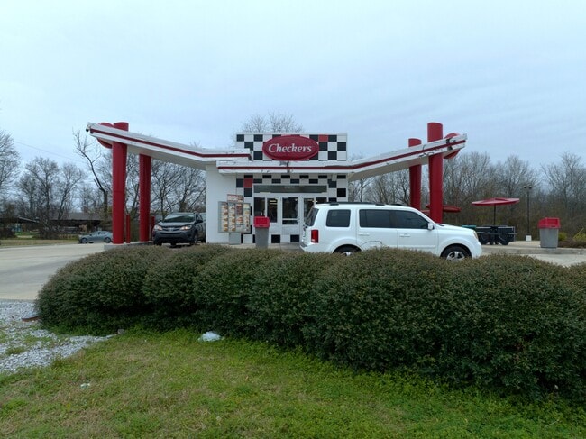
This Property Is For Sale
NEARBY LISTINGS FOR SALE OR LEASE
-
-
View all West Point listings for sale on LoopNet.com
Property Detail
6720 Highway 45 Alt S
082D115B-0260000
LOT 7 DB 307/477
Commercialnec
Clay
AE
Mississippi
28025C0331D
7
2024
Vicksburg/Central Area
2024
Other Market Areas
950300
West Point, MS
1,035 SF
DEMOGRAPHICS near 6720 Highway 45 Alt S
1 Mile
3 Mile
5 Mile
2024 Total Population
3,651
9,836
11,608
2029 Population
3,586
9,671
11,425
Pop Growth 2024-2029
(1.78%)
(1.68%)
(1.58%)
Average Age
39
41
41
2024 Total Households
1,488
4,083
4,835
HH Growth 2024-2029
(1.68%)
(1.59%)
(1.51%)
Median Household Inc
$28,682
$34,335
$36,260
Avg Household Size
2.40
2.30
2.30
2024 Avg HH Vehicles
1.00
2.00
2.00
Median Home Value
$94,131
$108,977
$113,878
Median Year Built
1969
1971
1973
Nearby Places
Map Layers
Map Styles
 Street
 Aerial
- Restaurants
- Banks
- Shops
- Fitness
- Groceries
PUBLIC TRANSPORTATION
AIRPORT
Golden Triangle Regional
DRIVE
WALK
Distance
Golden Triangle Regional
26 min
15.4 mi
Nearby Properties
Address
Land Use
TOTAL SIZE
Lot Size
Zoning
Address
Land Use
TOTAL SIZE
Lot Size
Zoning
171,635 SF
37.01 AC
Address
Land Use
TOTAL SIZE
Lot Size
Zoning
151,568 SF
19.28 AC
Address
Land Use
TOTAL SIZE
Lot Size
Zoning
316,175 SF
150 AC
Address
Land Use
TOTAL SIZE
Lot Size
Zoning
8,185 SF
42 AC
Address
Land Use
TOTAL SIZE
Lot Size
Zoning
35,556 SF
2.04 AC
Address
Land Use
TOTAL SIZE
Lot Size
Zoning
10,489 SF
10 AC
Address
Land Use
TOTAL SIZE
Lot Size
Zoning
10,070 SF
5.54 AC
Address
Land Use
TOTAL SIZE
Lot Size
Zoning
57,536 SF
11.44 AC
Address
Land Use
TOTAL SIZE
Lot Size
Zoning
37,224 SF
2.98 AC
Address
Land Use
TOTAL SIZE
Lot Size
Zoning
26,311 SF
2.06 AC
Address
Land Use
TOTAL SIZE
Lot Size
Zoning
5,777 SF
5.80 AC
Address
Land Use
TOTAL SIZE
Lot Size
Zoning
9,100 SF
2 AC
Address
Land Use
TOTAL SIZE
Lot Size
Zoning
15,355 SF
Address
Land Use
TOTAL SIZE
Lot Size
Zoning
89,600 SF
17.80 AC
Address
Land Use
TOTAL SIZE
Lot Size
Zoning
11,550 SF
Address
Land Use
TOTAL SIZE
Lot Size
Zoning
34,160 SF
19.20 AC
Address
Land Use
TOTAL SIZE
Lot Size
Zoning
5,627 SF
5.57 AC
Address
Land Use
TOTAL SIZE
Lot Size
Zoning
16,547 SF
28.13 AC
Address
Land Use
TOTAL SIZE
Lot Size
Zoning
25,340 SF
57.50 AC
Address
Land Use
TOTAL SIZE
Lot Size
Zoning
37,800 SF
13 AC
Address
Land Use
TOTAL SIZE
Lot Size
Zoning
10,706 SF
8 AC
Address
Land Use
TOTAL SIZE
Lot Size
Zoning
7,120 SF
3.24 AC
Address
Land Use
TOTAL SIZE
Lot Size
Zoning
9,614 SF
2.60 AC
Address
Land Use
TOTAL SIZE
Lot Size
Zoning
12,433 SF
1.66 AC
Address
Land Use
TOTAL SIZE
Lot Size
Zoning
21,498 SF
Address
Land Use
TOTAL SIZE
Lot Size
Zoning
4,221 SF
1.78 AC
Address
Land Use
TOTAL SIZE
Lot Size
Zoning
28,560 SF
8.50 AC
The World's #1 Commercial Real Estate Marketplace
Connect with us
© 2025 CoStar Group
The information above has been obtained from sources believed reliable. While we do not doubt its accuracy we have not verified it and make no guarantee, warranty or representation about it. It is your responsibility to independently confirm its accuracy and completeness. Any projections, opinions, assumptions, or estimates used are for example only and do not represent the current or future performance of the property. The value of this transaction to you depends on tax and other factors which should be evaluated by your tax, financial, and legal advisors. You and your advisors should conduct a careful, independent investigation of the property to determine to your satisfaction the suitability of the property for your needs.