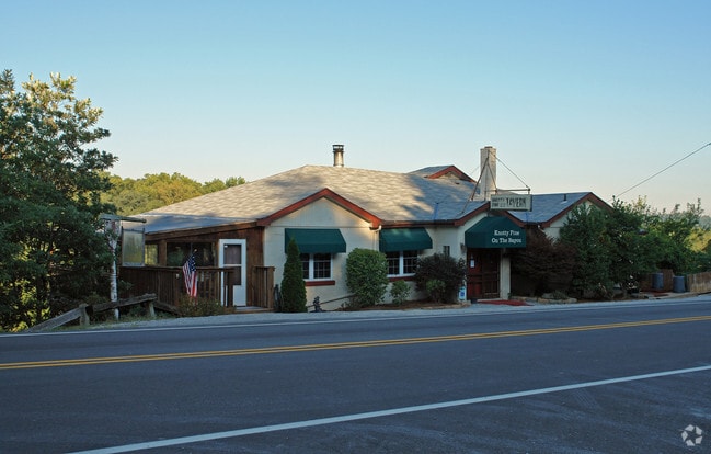
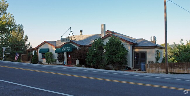
Property Record
6720 Licking Pike, Cold Spring, KY 41076
NEARBY LISTINGS FOR SALE OR LEASE
Property Detail
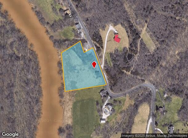
6720 Licking Pike
999-99-17-882.00
CONT 3.3913 ACRES
Commercialnec
Campbell
AE
Kentucky
21037C0077E
3.39 AC
2024
Outlying N Kentucky
2025
Cincinnati/Dayton
053100
Cincinnati, OH-KY-IN
DEMOGRAPHICS near 6720 Licking Pike
1 Mile
3 Mile
5 Mile
2024 Total Population
1,753
19,864
67,338
2029 Population
1,735
20,014
68,323
Pop Growth 2024-2029
(1.03%)
+ 0.76%
+ 1.46%
Average Age
44
42
40
2024 Total Households
752
8,263
26,688
HH Growth 2024-2029
(1.06%)
+ 0.69%
+ 1.40%
Median Household Inc
$92,889
$71,215
$72,886
Avg Household Size
2.30
2.30
2.40
2024 Avg HH Vehicles
2.00
2.00
2.00
Median Home Value
$254,733
$216,934
$210,353
Median Year Built
1999
1990
1984
Nearby Places
Map Layers
Map Styles
 Street
 Aerial
- Restaurants
- Banks
- Shops
- Fitness
- Groceries
PUBLIC TRANSPORTATION
AIRPORT
Cincinnati/Northern Kentucky International
DRIVE
WALK
Distance
Cincinnati/Northern Kentucky International
25 min
14.7 mi
Nearby Properties
Address
Land Use
TOTAL SIZE
Lot Size
Zoning
Address
Land Use
TOTAL SIZE
Lot Size
Zoning
560 SF
218.94 AC
Address
Land Use
TOTAL SIZE
Lot Size
Zoning
243,000 SF
11.30 AC
Address
Land Use
TOTAL SIZE
Lot Size
Zoning
0.95 AC
Address
Land Use
TOTAL SIZE
Lot Size
Zoning
0.83 AC
Address
Land Use
TOTAL SIZE
Lot Size
Zoning
0.74 AC
Address
Land Use
TOTAL SIZE
Lot Size
Zoning
0.71 AC
Address
Land Use
TOTAL SIZE
Lot Size
Zoning
0.71 AC
Address
Land Use
TOTAL SIZE
Lot Size
Zoning
360,000 SF
Address
Land Use
TOTAL SIZE
Lot Size
Zoning
0.53 AC
Address
Land Use
TOTAL SIZE
Lot Size
Zoning
0.56 AC
Address
Land Use
TOTAL SIZE
Lot Size
Zoning
0.57 AC
Address
Land Use
TOTAL SIZE
Lot Size
Zoning
0.49 AC
Address
Land Use
TOTAL SIZE
Lot Size
Zoning
0.59 AC
Address
Land Use
TOTAL SIZE
Lot Size
Zoning
0.48 AC
Address
Land Use
TOTAL SIZE
Lot Size
Zoning
0.40 AC
Address
Land Use
TOTAL SIZE
Lot Size
Zoning
1,049,050 SF
8.60 AC
Address
Land Use
TOTAL SIZE
Lot Size
Zoning
0.33 AC
Address
Land Use
TOTAL SIZE
Lot Size
Zoning
42,855 SF
9.07 AC
Address
Land Use
TOTAL SIZE
Lot Size
Zoning
1,800 SF
10.18 AC
Address
Land Use
TOTAL SIZE
Lot Size
Zoning
16.50 AC
Address
Land Use
TOTAL SIZE
Lot Size
Zoning
15,570 SF
21.35 AC
Address
Land Use
TOTAL SIZE
Lot Size
Zoning
207,606 SF
24.33 AC
Address
Land Use
TOTAL SIZE
Lot Size
Zoning
2,837 SF
3.77 AC
Address
Land Use
TOTAL SIZE
Lot Size
Zoning
175,481 SF
38.92 AC
Address
Land Use
TOTAL SIZE
Lot Size
Zoning
211,091 SF
28.29 AC
Address
Land Use
TOTAL SIZE
Lot Size
Zoning
3,726,400 SF
12.60 AC
Address
Land Use
TOTAL SIZE
Lot Size
Zoning
173,940 SF
22.52 AC
Address
Land Use
TOTAL SIZE
Lot Size
Zoning
Address
Land Use
TOTAL SIZE
Lot Size
Zoning
29,264 SF
22.18 AC
Address
Land Use
TOTAL SIZE
Lot Size
Zoning
79,830 SF
10.12 AC
The World's #1 Commercial Real Estate Marketplace
Connect with us
© 2025 CoStar Group
The information above has been obtained from sources believed reliable. While we do not doubt its accuracy we have not verified it and make no guarantee, warranty or representation about it. It is your responsibility to independently confirm its accuracy and completeness. Any projections, opinions, assumptions, or estimates used are for example only and do not represent the current or future performance of the property. The value of this transaction to you depends on tax and other factors which should be evaluated by your tax, financial, and legal advisors. You and your advisors should conduct a careful, independent investigation of the property to determine to your satisfaction the suitability of the property for your needs.