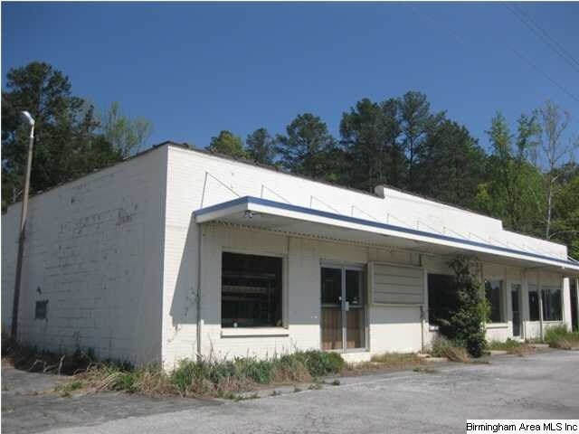
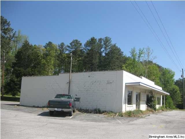
Property Record
6720 Mcclellan Blvd, Anniston, AL 36206
NEARBY LISTINGS FOR SALE OR LEASE
Property Detail
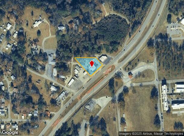
6720 Mcclellan Blvd
Anniston-Oxford-Jacksonville, AL
Northgate Sub
18-02-09-0-004-038.000
SEC 9 TSP 15S RNG 8E NORTHGATE SUB PT LTS 14 THRU 20 BEG NW COR LT 18 TH E ALG ROW 238.5 SE 106.6 SW ALG ROW 178.1 NW 264.36
Storebuilding
Calhoun
X
Alabama
01015C0306E
15-20
2025
0.74 AC
2025
Gadsden/Anniston Area
000700
Other Market Areas
3,047 SF
DEMOGRAPHICS near 6720 Mcclellan Blvd
1 Mile
3 Mile
5 Mile
2024 Total Population
627
11,949
29,418
2029 Population
619
11,735
29,046
Pop Growth 2024-2029
(1.28%)
(1.79%)
(1.26%)
Average Age
42
40
40
2024 Total Households
296
4,938
12,147
HH Growth 2024-2029
(1.69%)
(1.78%)
(1.27%)
Median Household Inc
$53,205
$49,820
$43,103
Avg Household Size
2.10
2.30
2.30
2024 Avg HH Vehicles
2.00
2.00
2.00
Median Home Value
$107,895
$122,025
$112,549
Median Year Built
1971
1975
1975
Nearby Places
Map Layers
Map Styles
 Street
 Aerial
- Restaurants
- Banks
- Shops
- Fitness
- Groceries
PUBLIC TRANSPORTATION
COMMUTER RAIL
Anniston Amtrak Station (Crescent - Amtrak)
DRIVE
WALK
Distance
Anniston Amtrak Station (Crescent - Amtrak)
12 min
7.0 mi
Freight Ports
Port of Panama City
DRIVE
WALK
Distance
Port of Panama City
373 min
298.8 mi
Nearby Properties
Address
Land Use
TOTAL SIZE
Lot Size
Zoning
Address
Land Use
TOTAL SIZE
Lot Size
Zoning
5,054 SF
11 AC
Address
Land Use
TOTAL SIZE
Lot Size
Zoning
18.55 AC
Address
Land Use
TOTAL SIZE
Lot Size
Zoning
138,119 SF
13.55 AC
Address
Land Use
TOTAL SIZE
Lot Size
Zoning
203,573 SF
17.16 AC
Address
Land Use
TOTAL SIZE
Lot Size
Zoning
133,349 SF
6.80 AC
Address
Land Use
TOTAL SIZE
Lot Size
Zoning
42,158 SF
5.20 AC
Address
Land Use
TOTAL SIZE
Lot Size
Zoning
71,060 SF
2.20 AC
Address
Land Use
TOTAL SIZE
Lot Size
Zoning
127,717 SF
10 AC
Address
Land Use
TOTAL SIZE
Lot Size
Zoning
40,266 SF
16 AC
Address
Land Use
TOTAL SIZE
Lot Size
Zoning
Address
Land Use
TOTAL SIZE
Lot Size
Zoning
Address
Land Use
TOTAL SIZE
Lot Size
Zoning
51,145 SF
2.49 AC
Address
Land Use
TOTAL SIZE
Lot Size
Zoning
14,208 SF
19 AC
Address
Land Use
TOTAL SIZE
Lot Size
Zoning
12,114 SF
7.10 AC
Address
Land Use
TOTAL SIZE
Lot Size
Zoning
35,580 SF
3.48 AC
Address
Land Use
TOTAL SIZE
Lot Size
Zoning
7,776 SF
1.85 AC
Address
Land Use
TOTAL SIZE
Lot Size
Zoning
7,924 SF
9.50 AC
Address
Land Use
TOTAL SIZE
Lot Size
Zoning
61,526 SF
5.64 AC
Address
Land Use
TOTAL SIZE
Lot Size
Zoning
12,768 SF
5 AC
Address
Land Use
TOTAL SIZE
Lot Size
Zoning
1,068 SF
7.63 AC
Address
Land Use
TOTAL SIZE
Lot Size
Zoning
15,518 SF
24 AC
Address
Land Use
TOTAL SIZE
Lot Size
Zoning
8,143 SF
4.80 AC
Address
Land Use
TOTAL SIZE
Lot Size
Zoning
56,920 SF
3 AC
Address
Land Use
TOTAL SIZE
Lot Size
Zoning
20,520 SF
2.39 AC
Address
Land Use
TOTAL SIZE
Lot Size
Zoning
19,137 SF
3.82 AC
Address
Land Use
TOTAL SIZE
Lot Size
Zoning
36,182 SF
3.24 AC
Address
Land Use
TOTAL SIZE
Lot Size
Zoning
10,602 SF
3.10 AC
Address
Land Use
TOTAL SIZE
Lot Size
Zoning
3,222 SF
0.74 AC
Address
Land Use
TOTAL SIZE
Lot Size
Zoning
2,387 SF
4.51 AC
Address
Land Use
TOTAL SIZE
Lot Size
Zoning
1,751 SF
8.30 AC
The World's #1 Commercial Real Estate Marketplace
Connect with us
© 2025 CoStar Group
The information above has been obtained from sources believed reliable. While we do not doubt its accuracy we have not verified it and make no guarantee, warranty or representation about it. It is your responsibility to independently confirm its accuracy and completeness. Any projections, opinions, assumptions, or estimates used are for example only and do not represent the current or future performance of the property. The value of this transaction to you depends on tax and other factors which should be evaluated by your tax, financial, and legal advisors. You and your advisors should conduct a careful, independent investigation of the property to determine to your satisfaction the suitability of the property for your needs.