Property Record
6725 E Us Highway 80, Longview, TX 75605


Save to a Folder
{{folder.Name}}
{{folder.ListingIds.length}} Properties
{{folder.ListingIds.length}} Property
Create a New Folder
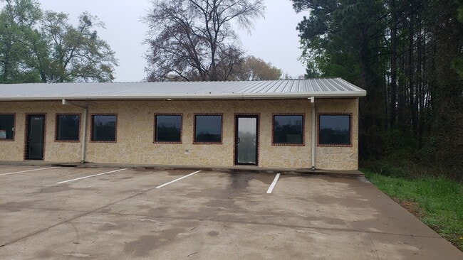
Property Detail
6725 E Us Highway 80
R010085497
ACRES: 3.976 ABST: 749 WM WATKINS OFC
Officebuilding
Harrison
B and X Area of moderate flood hazard, usually the area between the limits of the 100-year and 500-year floods.
Texas
2025
3.98 AC
2025
Longview
020605
Other Market Areas
5,000 SF
Longview, TX
NEARBY LISTINGS FOR SALE OR LEASE
DEMOGRAPHICS near 6725 E Us Highway 80
1 mile
3 mile
5 mile
2025 Total Population
838
6,369
20,121
2030 Population
851
6,483
20,495
Pop Growth 2025-2030
+ 1.55%
+ 1.79%
+ 1.86%
Average Age
39
38
39
2025 Total Households
286
2,231
7,272
HH Growth 2025-2030
+ 1.40%
+ 1.93%
+ 2.02%
Median Household Inc
$103,526
$91,779
$81,875
Avg Household Size
2.80
2.80
2.70
2025 Avg HH Vehicles
2.00
2.00
2.00
Median Home Value
$286,046
$270,742
$264,648
Median Year Built
2002
1997
1995
Nearby Places
Map Layers
Map Styles
 Street
 Aerial
Layers
 Traffic
 Biking
Places
Listings with unknown addresses are not visible on the map
- Restaurants
- Banks
- Shops
- Fitness
- Groceries
PUBLIC TRANSPORTATION
COMMUTER RAIL
Longview (Texas Eagle - Amtrak)
Drive
Walk
Distance
Longview (Texas Eagle - Amtrak)
11 min
6.9 mi
Freight Ports
Port of Shreveport
Drive
Walk
Distance
Port of Shreveport
80 min
66.4 mi
SALE & LEASE HISTORY
LISTING DATE
SALE/LEASE

Mar 11, 2023
For Lease
Jul 23, 2025
For Lease
Nearby Properties
Address
Land Use
TOTAL SIZE
Lot Size
Zoning
Address
Land Use
TOTAL SIZE
Lot Size
Zoning
326,021 SF
91.63 AC
Address
Land Use
TOTAL SIZE
Lot Size
Zoning
38,000 SF
1.29 AC
Address
Land Use
TOTAL SIZE
Lot Size
Zoning
8,320 SF
5.15 AC
Address
Land Use
TOTAL SIZE
Lot Size
Zoning
66,223 SF
5.23 AC
Address
Land Use
TOTAL SIZE
Lot Size
Zoning
36,964 SF
4.56 AC
Address
Land Use
TOTAL SIZE
Lot Size
Zoning
29,577 SF
18.53 AC
Address
Land Use
TOTAL SIZE
Lot Size
Zoning
3,140 SF
4.92 AC
Address
Land Use
TOTAL SIZE
Lot Size
Zoning
1,400 SF
3 AC
Address
Land Use
TOTAL SIZE
Lot Size
Zoning
4,021 SF
1.53 AC
Address
Land Use
TOTAL SIZE
Lot Size
Zoning
7,200 SF
8.05 AC
Address
Land Use
TOTAL SIZE
Lot Size
Zoning
3,909 SF
10 AC
Address
Land Use
TOTAL SIZE
Lot Size
Zoning
14,400 SF
3.06 AC
Address
Land Use
TOTAL SIZE
Lot Size
Zoning
36,708 SF
3.14 AC
Address
Land Use
TOTAL SIZE
Lot Size
Zoning
18,000 SF
3.26 AC
Address
Land Use
TOTAL SIZE
Lot Size
Zoning
3,098 SF
1.50 AC
Address
Land Use
TOTAL SIZE
Lot Size
Zoning
3,392 SF
1.01 AC
Address
Land Use
TOTAL SIZE
Lot Size
Zoning
8,047 SF
1.26 AC
Address
Land Use
TOTAL SIZE
Lot Size
Zoning
5,263 SF
0.88 AC
Address
Land Use
TOTAL SIZE
Lot Size
Zoning
16,800 SF
3.69 AC
Address
Land Use
TOTAL SIZE
Lot Size
Zoning
9,933 SF
1 AC
Address
Land Use
TOTAL SIZE
Lot Size
Zoning
15,580 SF
1.38 AC
Address
Land Use
TOTAL SIZE
Lot Size
Zoning
6,160 SF
1.12 AC
Address
Land Use
TOTAL SIZE
Lot Size
Zoning
3,680 SF
2.98 AC
Address
Land Use
TOTAL SIZE
Lot Size
Zoning
8,018 SF
2 AC
Address
Land Use
TOTAL SIZE
Lot Size
Zoning
3,290 SF
1.37 AC
Address
Land Use
TOTAL SIZE
Lot Size
Zoning
Address
Land Use
TOTAL SIZE
Lot Size
Zoning
8,740 SF
1.01 AC
Address
Land Use
TOTAL SIZE
Lot Size
Zoning
4,144 SF
1 AC
Address
Land Use
TOTAL SIZE
Lot Size
Zoning
3,036 SF
1 AC
Address
Land Use
TOTAL SIZE
Lot Size
Zoning
2,110 SF
12.80 AC
The World's #1 Commercial Real Estate Marketplace
Connect with us
© 2026 CoStar Group
The information above has been obtained from sources believed reliable. While we do not doubt its accuracy we have not verified it and make no guarantee, warranty or representation about it. It is your responsibility to independently confirm its accuracy and completeness. Any projections, opinions, assumptions, or estimates used are for example only and do not represent the current or future performance of the property. The value of this transaction to you depends on tax and other factors which should be evaluated by your tax, financial, and legal advisors. You and your advisors should conduct a careful, independent investigation of the property to determine to your satisfaction the suitability of the property for your needs.