Property Record
6725 Highway 17, Clarkesville, GA 30523
NEARBY LISTINGS FOR SALE OR LEASE
-
-
View all Clarkesville listings for sale on LoopNet.com
Property Detail
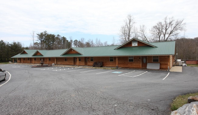
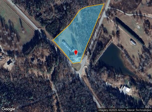
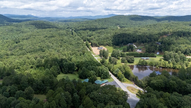
6725 Highway 17
019-040
Rick & Tiny Randolph
Restaurantbuilding
3-110 111 82 83 PB 61-177 1368-891
X
Habersham
13137C0095D
Georgia
2025
5.55 AC
2025
Georgia Northeast
000203
Other Market Areas
2,100 SF
Cornelia, GA
DEMOGRAPHICS near 6725 Highway 17
1 Mile
3 Mile
5 Mile
2024 Total Population
470
2,826
9,206
2029 Population
517
3,098
10,092
Pop Growth 2024-2029
+ 10.00%
+ 9.62%
+ 9.62%
Average Age
47
47
47
2024 Total Households
191
1,146
3,809
HH Growth 2024-2029
+ 9.42%
+ 9.25%
+ 9.29%
Median Household Inc
$60,978
$62,235
$65,282
Avg Household Size
2.50
2.40
2.40
2024 Avg HH Vehicles
2.00
2.00
2.00
Median Home Value
$251,818
$262,430
$254,008
Median Year Built
1993
1995
1994
Nearby Places
Map Layers
Map Styles
 Street
 Aerial
- Restaurants
- Banks
- Shops
- Fitness
- Groceries
SALE & LEASE HISTORY
LISTING DATE
SALE/LEASE

Sep 13, 2025
For Sale
Feb 06, 2024
For Sale
Dec 15, 2022
For Sale
Dec 03, 2021
For Sale
Aug 13, 2025
For Sale
Nearby Properties
Address
Land Use
TOTAL SIZE
Lot Size
Zoning
Address
Land Use
TOTAL SIZE
Lot Size
Zoning
7,544 SF
32.63 AC
A1
Address
Land Use
TOTAL SIZE
Lot Size
Zoning
5,944 SF
6 AC
A1
Address
Land Use
TOTAL SIZE
Lot Size
Zoning
351.54 AC
LI
Address
Land Use
TOTAL SIZE
Lot Size
Zoning
327 AC
LI
Address
Land Use
TOTAL SIZE
Lot Size
Zoning
2,800 SF
1.35 AC
C1
Address
Land Use
TOTAL SIZE
Lot Size
Zoning
243.72 AC
LI
Address
Land Use
TOTAL SIZE
Lot Size
Zoning
2,464 SF
22.17 AC
C2
Address
Land Use
TOTAL SIZE
Lot Size
Zoning
5,673 SF
1.97 AC
A1
Address
Land Use
TOTAL SIZE
Lot Size
Zoning
155.49 AC
A1
Address
Land Use
TOTAL SIZE
Lot Size
Zoning
23,870 SF
2.31 AC
HI
Address
Land Use
TOTAL SIZE
Lot Size
Zoning
118.65 AC
A1
Address
Land Use
TOTAL SIZE
Lot Size
Zoning
126.78 AC
LI
Address
Land Use
TOTAL SIZE
Lot Size
Zoning
116.76 AC
LI
Address
Land Use
TOTAL SIZE
Lot Size
Zoning
80 AC
A1
Address
Land Use
TOTAL SIZE
Lot Size
Zoning
8,100 SF
3.13 AC
HI
Address
Land Use
TOTAL SIZE
Lot Size
Zoning
100 AC
AGRI
Address
Land Use
TOTAL SIZE
Lot Size
Zoning
100 AC
AGRI
Address
Land Use
TOTAL SIZE
Lot Size
Zoning
90.37 AC
A1
Address
Land Use
TOTAL SIZE
Lot Size
Zoning
79.12 AC
A1
Address
Land Use
TOTAL SIZE
Lot Size
Zoning
71.50 AC
A1
Address
Land Use
TOTAL SIZE
Lot Size
Zoning
3,128 SF
5.21 AC
C1
Address
Land Use
TOTAL SIZE
Lot Size
Zoning
81.22 AC
A1
Address
Land Use
TOTAL SIZE
Lot Size
Zoning
136.12 AC
LI
Address
Land Use
TOTAL SIZE
Lot Size
Zoning
17,376 SF
5.59 AC
HI
Address
Land Use
TOTAL SIZE
Lot Size
Zoning
4,800 SF
2.15 AC
HI
Address
Land Use
TOTAL SIZE
Lot Size
Zoning
67.52 AC
A1
Address
Land Use
TOTAL SIZE
Lot Size
Zoning
59 AC
A1
Address
Land Use
TOTAL SIZE
Lot Size
Zoning
2,611 SF
66.80 AC
A1
Address
Land Use
TOTAL SIZE
Lot Size
Zoning
1,232 SF
1.34 AC
C1
The World's #1 Commercial Real Estate Marketplace
Connect with us
© 2025 CoStar Group
The information above has been obtained from sources believed reliable. While we do not doubt its accuracy we have not verified it and make no guarantee, warranty or representation about it. It is your responsibility to independently confirm its accuracy and completeness. Any projections, opinions, assumptions, or estimates used are for example only and do not represent the current or future performance of the property. The value of this transaction to you depends on tax and other factors which should be evaluated by your tax, financial, and legal advisors. You and your advisors should conduct a careful, independent investigation of the property to determine to your satisfaction the suitability of the property for your needs.