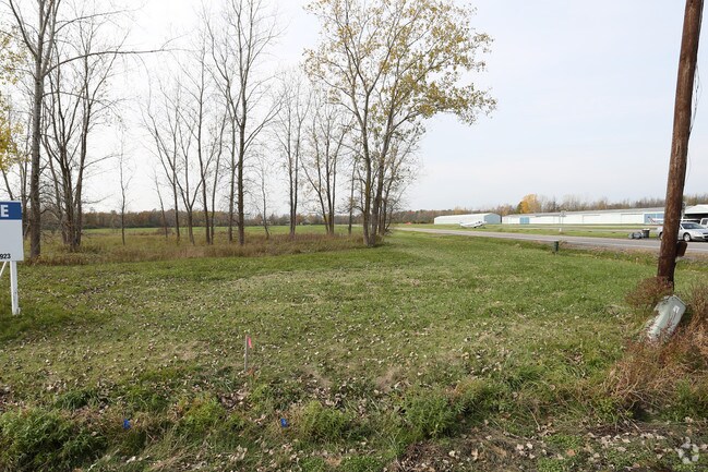
Property Record
6726 S Transit Rd, Lockport, NY 14094

Property Detail
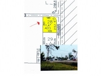
6726 S Transit Rd
293200-151-000-0002-028-000
NIAGARA
Storebuilding
New York
R-2 RESI
28.000
B and X Area of moderate flood hazard, usually the area between the limits of the 100-year and 500-year floods.
1.40 AC
2025
Outlying Niagara County
2025
Buffalo/Niagara Falls
022702
Buffalo-Cheektowaga, NY
NEARBY LISTINGS FOR SALE OR LEASE
DEMOGRAPHICS near 6726 S Transit Rd
1 mile
3 mile
5 mile
2025 Total Population
1,559
15,630
46,856
2030 Population
1,555
15,689
46,697
Pop Growth 2025-2030
(0.26%)
+ 0.38%
(0.34%)
Average Age
41
42
43
2025 Total Households
636
6,706
20,089
HH Growth 2025-2030
(0.31%)
+ 0.42%
(0.38%)
Median Household Inc
$75,333
$69,086
$78,567
Avg Household Size
2.40
2.30
2.30
2025 Avg HH Vehicles
2.00
2.00
2.00
Median Home Value
$304,687
$231,013
$235,961
Median Year Built
1994
1988
1976
Nearby Places
Map Layers
Map Styles
 Street
 Aerial
Layers
 Traffic
 Biking
Places
Listings with unknown addresses are not visible on the map
- Restaurants
- Banks
- Shops
- Fitness
- Groceries
PUBLIC TRANSPORTATION
AIRPORT
Buffalo Niagara International
Drive
Walk
Distance
Buffalo Niagara International
18 min
12.6 mi
Niagara Falls International
Drive
Walk
Distance
Niagara Falls International
26 min
16.1 mi
Freight Ports
Albany, NY Port
Drive
Walk
Distance
Albany, NY Port
338 min
288.8 mi
SALE & LEASE HISTORY
LISTING DATE
SALE/LEASE

Nov 04, 2016
For Sale
Nearby Properties
Address
Land Use
TOTAL SIZE
Lot Size
Zoning
Address
Land Use
TOTAL SIZE
Lot Size
Zoning
198.40 AC
Address
Land Use
TOTAL SIZE
Lot Size
Zoning
5,364 SF
56.45 AC
Address
Land Use
TOTAL SIZE
Lot Size
Zoning
4,436 SF
18.51 AC
Address
Land Use
TOTAL SIZE
Lot Size
Zoning
90,347 SF
18.66 AC
B-2
Address
Land Use
TOTAL SIZE
Lot Size
Zoning
516 SF
53.70 AC
Address
Land Use
TOTAL SIZE
Lot Size
Zoning
4,417 SF
61.30 AC
Address
Land Use
TOTAL SIZE
Lot Size
Zoning
9,338 SF
6.20 AC
Address
Land Use
TOTAL SIZE
Lot Size
Zoning
130,160 SF
13 AC
B-2
Address
Land Use
TOTAL SIZE
Lot Size
Zoning
280 SF
31 AC
Address
Land Use
TOTAL SIZE
Lot Size
Zoning
140,048 SF
13.60 AC
B-2
Address
Land Use
TOTAL SIZE
Lot Size
Zoning
792 SF
20.30 AC
Address
Land Use
TOTAL SIZE
Lot Size
Zoning
51,125 SF
12.20 AC
Address
Land Use
TOTAL SIZE
Lot Size
Zoning
23,904 SF
2 AC
Address
Land Use
TOTAL SIZE
Lot Size
Zoning
52,000 SF
30.40 AC
R-1
Address
Land Use
TOTAL SIZE
Lot Size
Zoning
130,946 SF
11.10 AC
B-2
Address
Land Use
TOTAL SIZE
Lot Size
Zoning
21,216 SF
3.90 AC
Address
Land Use
TOTAL SIZE
Lot Size
Zoning
4,736 SF
8.90 AC
Address
Land Use
TOTAL SIZE
Lot Size
Zoning
40,871 SF
27.20 AC
Address
Land Use
TOTAL SIZE
Lot Size
Zoning
36,725 SF
7 AC
B-2
Address
Land Use
TOTAL SIZE
Lot Size
Zoning
24,233 SF
4.99 AC
B-2
Address
Land Use
TOTAL SIZE
Lot Size
Zoning
45,930 SF
17 AC
Address
Land Use
TOTAL SIZE
Lot Size
Zoning
4.23 AC
Address
Land Use
TOTAL SIZE
Lot Size
Zoning
1,120 SF
4.40 AC
Address
Land Use
TOTAL SIZE
Lot Size
Zoning
884 SF
35 AC
Address
Land Use
TOTAL SIZE
Lot Size
Zoning
27,772 SF
9.80 AC
B-1
Address
Land Use
TOTAL SIZE
Lot Size
Zoning
78,640 SF
15.60 AC
R-2 RESI
Address
Land Use
TOTAL SIZE
Lot Size
Zoning
40,599 SF
5.90 AC
R-2
Address
Land Use
TOTAL SIZE
Lot Size
Zoning
6,108 SF
1.50 AC
Address
Land Use
TOTAL SIZE
Lot Size
Zoning
51,060 SF
4.60 AC
Address
Land Use
TOTAL SIZE
Lot Size
Zoning
33,685 SF
9.26 AC
MED COM
The World's #1 Commercial Real Estate Marketplace
Connect with us
© 2026 CoStar Group
The information above has been obtained from sources believed reliable. While we do not doubt its accuracy we have not verified it and make no guarantee, warranty or representation about it. It is your responsibility to independently confirm its accuracy and completeness. Any projections, opinions, assumptions, or estimates used are for example only and do not represent the current or future performance of the property. The value of this transaction to you depends on tax and other factors which should be evaluated by your tax, financial, and legal advisors. You and your advisors should conduct a careful, independent investigation of the property to determine to your satisfaction the suitability of the property for your needs.