Property Record
6726 Spacek Rd, Rosenberg, TX 77471
Property Detail
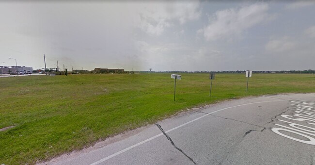
6726 Spacek Rd
Houston-Pasadena-The Woodlands, TX
0187 R E HANDY, ACRES 2.2318, TRACT 2
0187-00-000-0013-901
FORT BEND
Residentialacreage
Texas
B and X Area of moderate flood hazard, usually the area between the limits of the 100-year and 500-year floods.
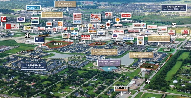
8.98 AC
2023
Southwest Outlier
2025
Houston
675300
NEARBY LISTINGS FOR SALE OR LEASE
DEMOGRAPHICS near 6726 Spacek Rd
1 mile
3 mile
5 mile
2024 Total Population
9,807
73,906
136,284
2029 Population
11,360
84,746
155,795
Pop Growth 2024-2029
+ 15.84%
+ 14.67%
+ 14.32%
Average Age
37
38
38
2024 Total Households
3,612
25,502
45,508
HH Growth 2024-2029
+ 16.22%
+ 15.11%
+ 14.74%
Median Household Inc
$85,840
$85,988
$87,957
Avg Household Size
2.70
2.80
2.90
2024 Avg HH Vehicles
2.00
2.00
2.00
Median Home Value
$315,804
$331,284
$323,016
Median Year Built
2011
2010
2008
Nearby Places
Map Layers
Map Styles
 Street
 Aerial
Transit
 Traffic
 Biking
Places
Listings with unknown addresses are not visible on the map
- Restaurants
- Banks
- Shops
- Fitness
- Groceries
PUBLIC TRANSPORTATION
AIRPORT
William P Hobby
Drive
Walk
Distance
William P Hobby
51 min
36.3 mi
SALE & LEASE HISTORY
LISTING DATE
SALE/LEASE

Sep 24, 2016
For Sale
May 13, 2025
For Sale
Jan 27, 2022
For Sale
Nearby Properties
Address
Land Use
TOTAL SIZE
Lot Size
Zoning
Address
Land Use
TOTAL SIZE
Lot Size
Zoning
50.46 AC
Address
Land Use
TOTAL SIZE
Lot Size
Zoning
449,167 SF
73.44 AC
IY
Address
Land Use
TOTAL SIZE
Lot Size
Zoning
504,838 SF
30.59 AC
Address
Land Use
TOTAL SIZE
Lot Size
Zoning
133,259 SF
9.99 AC
Address
Land Use
TOTAL SIZE
Lot Size
Zoning
283,393 SF
93.42 AC
Address
Land Use
TOTAL SIZE
Lot Size
Zoning
11.65 AC
Address
Land Use
TOTAL SIZE
Lot Size
Zoning
10.84 AC
Address
Land Use
TOTAL SIZE
Lot Size
Zoning
307,832 SF
14.06 AC
Address
Land Use
TOTAL SIZE
Lot Size
Zoning
15.95 AC
Address
Land Use
TOTAL SIZE
Lot Size
Zoning
Address
Land Use
TOTAL SIZE
Lot Size
Zoning
13.21 AC
Address
Land Use
TOTAL SIZE
Lot Size
Zoning
78,077 SF
16.29 AC
Address
Land Use
TOTAL SIZE
Lot Size
Zoning
85,021 SF
12 AC
Address
Land Use
TOTAL SIZE
Lot Size
Zoning
81,128 SF
8.98 AC
YNQS
Address
Land Use
TOTAL SIZE
Lot Size
Zoning
212,000 SF
0.49 AC
Address
Land Use
TOTAL SIZE
Lot Size
Zoning
89,753 SF
10.61 AC
Address
Land Use
TOTAL SIZE
Lot Size
Zoning
169,798 SF
16.29 AC
Address
Land Use
TOTAL SIZE
Lot Size
Zoning
224,099 SF
11.85 AC
Address
Land Use
TOTAL SIZE
Lot Size
Zoning
11.40 AC
Address
Land Use
TOTAL SIZE
Lot Size
Zoning
Address
Land Use
TOTAL SIZE
Lot Size
Zoning
129,092 SF
9.55 AC
Address
Land Use
TOTAL SIZE
Lot Size
Zoning
16.23 AC
Address
Land Use
TOTAL SIZE
Lot Size
Zoning
60.86 AC
Address
Land Use
TOTAL SIZE
Lot Size
Zoning
16.48 AC
Address
Land Use
TOTAL SIZE
Lot Size
Zoning
54,406 SF
13.13 AC
Address
Land Use
TOTAL SIZE
Lot Size
Zoning
Address
Land Use
TOTAL SIZE
Lot Size
Zoning
3,680 SF
38.68 AC
SMH
Address
Land Use
TOTAL SIZE
Lot Size
Zoning
20,000,000 SF
5 AC
Address
Land Use
TOTAL SIZE
Lot Size
Zoning
18.86 AC
Address
Land Use
TOTAL SIZE
Lot Size
Zoning
12.21 AC
The World's #1 Commercial Real Estate Marketplace
Connect with us
© 2026 CoStar Group
The information above has been obtained from sources believed reliable. While we do not doubt its accuracy we have not verified it and make no guarantee, warranty or representation about it. It is your responsibility to independently confirm its accuracy and completeness. Any projections, opinions, assumptions, or estimates used are for example only and do not represent the current or future performance of the property. The value of this transaction to you depends on tax and other factors which should be evaluated by your tax, financial, and legal advisors. You and your advisors should conduct a careful, independent investigation of the property to determine to your satisfaction the suitability of the property for your needs.