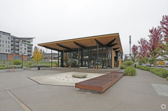
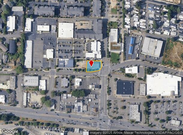
Property Record
6728 Ne 181St St, Kenmore, WA 98028

NEARBY LISTINGS FOR SALE OR LEASE
Property Detail
6728 Ne 181St St
Seattle-Tacoma-Bellevue, WA
Kenmore Village Parcel B Bsp
382020-0050
KENMORE VILLAGE PARCEL B BSP REC VOL 268 PGS 54-55 (REC 20150206000972)
Restaurantdrivein
King
X
Washington
53033C0063H
g
2021
0.26 AC
2024
Bothell/Kenmore
021600
Seattle/Puget Sound
4,576 SF
DEMOGRAPHICS near 6728 Ne 181St St
1 Mile
3 Mile
5 Mile
2024 Total Population
12,475
105,425
347,016
2029 Population
12,563
107,086
355,052
Pop Growth 2024-2029
+ 0.71%
+ 1.58%
+ 2.32%
Average Age
41
41
40
2024 Total Households
5,201
41,837
138,857
HH Growth 2024-2029
+ 0.60%
+ 1.52%
+ 2.30%
Median Household Inc
$113,660
$121,832
$110,510
Avg Household Size
2.40
2.50
2.40
2024 Avg HH Vehicles
2.00
2.00
2.00
Median Home Value
$779,834
$784,334
$762,833
Median Year Built
1984
1982
1981
Nearby Places
Map Layers
Map Styles
 Street
 Aerial
- Restaurants
- Banks
- Shops
- Fitness
- Groceries
PUBLIC TRANSPORTATION
COMMUTER RAIL
Edmonds Station (Sounder South Line - Central Puget Sound Regional Transit Authority Rail (Link Light Rail/Sounder))
DRIVE
WALK
Distance
Edmonds Station (Sounder South Line - Central Puget Sound Regional Transit Authority Rail (Link Light Rail/Sounder))
18 min
8.8 mi
AIRPORT
Seattle Paine Field International
DRIVE
WALK
Distance
Seattle Paine Field International
25 min
13.1 mi
Seattle-Tacoma International
DRIVE
WALK
Distance
Seattle-Tacoma International
43 min
27.7 mi
Freight Ports
Port of Seattle
DRIVE
WALK
Distance
Port of Seattle
30 min
18.2 mi
Nearby Properties
Address
Land Use
TOTAL SIZE
Lot Size
Zoning
Address
Land Use
TOTAL SIZE
Lot Size
Zoning
50,400 SF
123.66 AC
C
Address
Land Use
TOTAL SIZE
Lot Size
Zoning
444,231 SF
31.50 AC
SDD/R
Address
Land Use
TOTAL SIZE
Lot Size
Zoning
2.60 AC
DN
Address
Land Use
TOTAL SIZE
Lot Size
Zoning
194,388 SF
1.65 AC
DC
Address
Land Use
TOTAL SIZE
Lot Size
Zoning
170,520 SF
1.92 AC
DN
Address
Land Use
TOTAL SIZE
Lot Size
Zoning
217,877 SF
17.03 AC
R 2,800
Address
Land Use
TOTAL SIZE
Lot Size
Zoning
75,661 SF
30.54 AC
R 8400
Address
Land Use
TOTAL SIZE
Lot Size
Zoning
131,236 SF
19.14 AC
R6
Address
Land Use
TOTAL SIZE
Lot Size
Zoning
184,576 SF
9.56 AC
RMA 1.8
Address
Land Use
TOTAL SIZE
Lot Size
Zoning
122,766 SF
2 AC
GDC
Address
Land Use
TOTAL SIZE
Lot Size
Zoning
204,428 SF
34.65 AC
R 9600
Address
Land Use
TOTAL SIZE
Lot Size
Zoning
119,470 SF
1.56 AC
DN
Address
Land Use
TOTAL SIZE
Lot Size
Zoning
114,513 SF
2.35 AC
GDC
Address
Land Use
TOTAL SIZE
Lot Size
Zoning
113,880 SF
1.56 AC
GDC
Address
Land Use
TOTAL SIZE
Lot Size
Zoning
177,990 SF
50.72 AC
PUBLIC/SEM
Address
Land Use
TOTAL SIZE
Lot Size
Zoning
194,954 SF
49.73 AC
PUBLIC/SEM
Address
Land Use
TOTAL SIZE
Lot Size
Zoning
120,420 SF
0.94 AC
DN
Address
Land Use
TOTAL SIZE
Lot Size
Zoning
220,968 SF
16.46 AC
TC
Address
Land Use
TOTAL SIZE
Lot Size
Zoning
236,309 SF
43.88 AC
R6
Address
Land Use
TOTAL SIZE
Lot Size
Zoning
95,892 SF
1.05 AC
DT
Address
Land Use
TOTAL SIZE
Lot Size
Zoning
141,044 SF
5.46 AC
R 9600, SS
Address
Land Use
TOTAL SIZE
Lot Size
Zoning
308.56 AC
P
Address
Land Use
TOTAL SIZE
Lot Size
Zoning
158,688 SF
5.78 AC
RM 900
Address
Land Use
TOTAL SIZE
Lot Size
Zoning
134,964 SF
8.87 AC
R18
Address
Land Use
TOTAL SIZE
Lot Size
Zoning
41.24 AC
R 9,600
Address
Land Use
TOTAL SIZE
Lot Size
Zoning
75,644 SF
5.50 AC
P
Address
Land Use
TOTAL SIZE
Lot Size
Zoning
85,522 SF
0.53 AC
DC
Address
Land Use
TOTAL SIZE
Lot Size
Zoning
142,992 SF
3.16 AC
R 2800, OP
Address
Land Use
TOTAL SIZE
Lot Size
Zoning
88,090 SF
1.33 AC
DN
Address
Land Use
TOTAL SIZE
Lot Size
Zoning
78,866 SF
1.10 AC
DC
The World's #1 Commercial Real Estate Marketplace
Connect with us
© 2025 CoStar Group
The information above has been obtained from sources believed reliable. While we do not doubt its accuracy we have not verified it and make no guarantee, warranty or representation about it. It is your responsibility to independently confirm its accuracy and completeness. Any projections, opinions, assumptions, or estimates used are for example only and do not represent the current or future performance of the property. The value of this transaction to you depends on tax and other factors which should be evaluated by your tax, financial, and legal advisors. You and your advisors should conduct a careful, independent investigation of the property to determine to your satisfaction the suitability of the property for your needs.