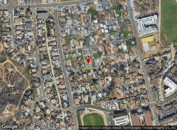
Property Record
6728 Thomson Ct, San Diego, CA 92111
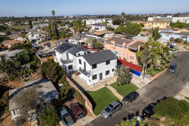
This Property Is For Sale
NEARBY LISTINGS FOR SALE OR LEASE
Property Detail
6728 Thomson Ct
San Diego-Carlsbad, CA
Linda Vista Heights
431-210-65
BLK 19 LOT 81 TR 003209
Multifamilydwelling
San Diego
X
California
06073C1616G
81
2024
0.14 AC
2025
Linda Vista
008600
San Diego
4,230 SF
DEMOGRAPHICS near 6728 Thomson Ct
1 Mile
3 Mile
5 Mile
2024 Total Population
21,631
159,868
434,514
2029 Population
21,581
160,520
436,417
Pop Growth 2024-2029
(0.23%)
+ 0.41%
+ 0.44%
Average Age
38
39
39
2024 Total Households
7,188
66,438
195,567
HH Growth 2024-2029
(0.67%)
+ 0.45%
+ 0.44%
Median Household Inc
$81,946
$93,786
$93,412
Avg Household Size
2.80
2.20
2.10
2024 Avg HH Vehicles
2.00
2.00
2.00
Median Home Value
$713,811
$782,644
$831,972
Median Year Built
1972
1974
1973
Nearby Places
Map Layers
Map Styles
 Street
 Aerial
- Restaurants
- Banks
- Shops
- Fitness
- Groceries
PUBLIC TRANSPORTATION
COMMUTER RAIL
Old Town Transit Center (Coaster - San Diego North County Transit District (Coaster/Sprinter/Breeze))
DRIVE
WALK
Distance
Old Town Transit Center (Coaster - San Diego North County Transit District (Coaster/Sprinter/Breeze))
9 min
3.9 mi
San Diego (Santa Fe Depot) (Coaster - San Diego North County Transit District (Coaster/Sprinter/Breeze))
DRIVE
WALK
Distance
San Diego (Santa Fe Depot) (Coaster - San Diego North County Transit District (Coaster/Sprinter/Breeze))
13 min
7.7 mi
AIRPORT
San Diego International
DRIVE
WALK
Distance
San Diego International
13 min
6.7 mi
Freight Ports
Port of San Diego
DRIVE
WALK
Distance
Port of San Diego
16 min
8.9 mi
Nearby Properties
Address
Land Use
TOTAL SIZE
Lot Size
Zoning
Address
Land Use
TOTAL SIZE
Lot Size
Zoning
30,000 SF
62.51 AC
MVPD-MV-CR
Address
Land Use
TOTAL SIZE
Lot Size
Zoning
189,644 SF
20.49 AC
CO-1-2
Address
Land Use
TOTAL SIZE
Lot Size
Zoning
17.88 AC
CO-1-2
Address
Land Use
TOTAL SIZE
Lot Size
Zoning
12.97 AC
RM-3-7
Address
Land Use
TOTAL SIZE
Lot Size
Zoning
2.53 AC
EMX-1
Address
Land Use
TOTAL SIZE
Lot Size
Zoning
1.51 AC
CC-3-9
Address
Land Use
TOTAL SIZE
Lot Size
Zoning
6.96 AC
MVPD-MVR-4
Address
Land Use
TOTAL SIZE
Lot Size
Zoning
19.25 AC
CC-3-5
Address
Land Use
TOTAL SIZE
Lot Size
Zoning
15.37 AC
CC-3-8
Address
Land Use
TOTAL SIZE
Lot Size
Zoning
7.48 AC
RM-3-9
Address
Land Use
TOTAL SIZE
Lot Size
Zoning
2.50 AC
MVPD-MV-CO
Address
Land Use
TOTAL SIZE
Lot Size
Zoning
5.35 AC
MVPD-MV-CR
Address
Land Use
TOTAL SIZE
Lot Size
Zoning
7.69 AC
MVPD-MV-M/
Address
Land Use
TOTAL SIZE
Lot Size
Zoning
13.04 AC
RM-2-5
Address
Land Use
TOTAL SIZE
Lot Size
Zoning
7.19 AC
MVPD-MV-M/
Address
Land Use
TOTAL SIZE
Lot Size
Zoning
17.35 AC
C-6
Address
Land Use
TOTAL SIZE
Lot Size
Zoning
902,919 SF
45.23 AC
MVPD-MV-CR
Address
Land Use
TOTAL SIZE
Lot Size
Zoning
5.39 AC
CO-1-2
Address
Land Use
TOTAL SIZE
Lot Size
Zoning
2.90 AC
MVPD-MV-CR
Address
Land Use
TOTAL SIZE
Lot Size
Zoning
1.99 AC
EMX-1
Address
Land Use
TOTAL SIZE
Lot Size
Zoning
1.81 AC
EMX-1
Address
Land Use
TOTAL SIZE
Lot Size
Zoning
283,689 SF
18.02 AC
M
Address
Land Use
TOTAL SIZE
Lot Size
Zoning
16.91 AC
EMX-1
Address
Land Use
TOTAL SIZE
Lot Size
Zoning
3.36 AC
RM-4-10
Address
Land Use
TOTAL SIZE
Lot Size
Zoning
35,800 SF
50.27 AC
RM-1-1
Address
Land Use
TOTAL SIZE
Lot Size
Zoning
14,940 SF
3.24 AC
CO-1-2
Address
Land Use
TOTAL SIZE
Lot Size
Zoning
194,809 SF
19.82 AC
MVPD-MV-M/
Address
Land Use
TOTAL SIZE
Lot Size
Zoning
19.67 AC
RM-2-5
Address
Land Use
TOTAL SIZE
Lot Size
Zoning
2.46 AC
CC-3-5
Address
Land Use
TOTAL SIZE
Lot Size
Zoning
15.40 AC
MVPD-MV-M
The World's #1 Commercial Real Estate Marketplace
Connect with us
© 2025 CoStar Group
The information above has been obtained from sources believed reliable. While we do not doubt its accuracy we have not verified it and make no guarantee, warranty or representation about it. It is your responsibility to independently confirm its accuracy and completeness. Any projections, opinions, assumptions, or estimates used are for example only and do not represent the current or future performance of the property. The value of this transaction to you depends on tax and other factors which should be evaluated by your tax, financial, and legal advisors. You and your advisors should conduct a careful, independent investigation of the property to determine to your satisfaction the suitability of the property for your needs.