Property Record
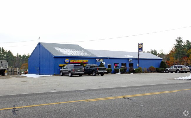
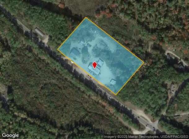
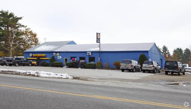
673 Nh Route 11, Farmington, NH 03835
NEARBY LISTINGS FOR SALE OR LEASE
-
-
View all Farmington listings for sale on LoopNet.com
Property Detail
673 Nh Route 11
FRMN-000035R-000000-000002
Strafford
Commercialnec
New Hampshire
A
2 s:0-0
33003C0825D
3.70 AC
2024
Strafford County
2024
Boston
087001
Boston-Cambridge-Newton, MA-NH
4,900 SF
DEMOGRAPHICS near 673 Nh Route 11
1 Mile
3 Mile
5 Mile
2024 Total Population
1,615
6,175
14,179
2029 Population
1,683
6,433
14,774
Pop Growth 2024-2029
+ 4.21%
+ 4.18%
+ 4.20%
Average Age
42
42
43
2024 Total Households
673
2,498
5,813
HH Growth 2024-2029
+ 4.16%
+ 4.16%
+ 4.23%
Median Household Inc
$47,177
$77,849
$92,713
Avg Household Size
2.30
2.40
2.40
2024 Avg HH Vehicles
2.00
2.00
2.00
Median Home Value
$231,104
$261,128
$264,181
Median Year Built
1971
1976
1981
Nearby Places
Map Layers
Map Styles
 Street
 Aerial
- Restaurants
- Banks
- Shops
- Fitness
- Groceries
PUBLIC TRANSPORTATION
AIRPORT
Portsmouth International at Pease
DRIVE
WALK
Distance
Portsmouth International at Pease
38 min
26.1 mi
Freight Ports
Portland, ME
DRIVE
WALK
Distance
Portland, ME
79 min
56.0 mi
Nearby Properties
Address
Land Use
TOTAL SIZE
Lot Size
Zoning
Address
Land Use
TOTAL SIZE
Lot Size
Zoning
82,235 SF
20 AC
UR URB
Address
Land Use
TOTAL SIZE
Lot Size
Zoning
1,156 SF
1.95 AC
VC VIL
Address
Land Use
TOTAL SIZE
Lot Size
Zoning
74,617 SF
21.62 AC
SR SUB
Address
Land Use
TOTAL SIZE
Lot Size
Zoning
56,486 SF
16.60 AC
SR SUB
Address
Land Use
TOTAL SIZE
Lot Size
Zoning
66,994 SF
38.56 AC
IB IND
Address
Land Use
TOTAL SIZE
Lot Size
Zoning
15,085 SF
83.25 AC
SR SUB
Address
Land Use
TOTAL SIZE
Lot Size
Zoning
8,626 SF
9.95 AC
SR SUB
Address
Land Use
TOTAL SIZE
Lot Size
Zoning
32.73 AC
SR SUB
Address
Land Use
TOTAL SIZE
Lot Size
Zoning
1,800 SF
5.50 AC
CIBO C
Address
Land Use
TOTAL SIZE
Lot Size
Zoning
2.50 AC
SR SUB
Address
Land Use
TOTAL SIZE
Lot Size
Zoning
3,472 SF
4.65 AC
CB COM
Address
Land Use
TOTAL SIZE
Lot Size
Zoning
48 AC
SR SUB
Address
Land Use
TOTAL SIZE
Lot Size
Zoning
2,583 SF
1.30 AC
LOW DE
Address
Land Use
TOTAL SIZE
Lot Size
Zoning
4,032 SF
1.65 AC
CB COM
Address
Land Use
TOTAL SIZE
Lot Size
Zoning
7,215 SF
2.70 AC
SR SUB
Address
Land Use
TOTAL SIZE
Lot Size
Zoning
62,890 SF
10 AC
IB IND
Address
Land Use
TOTAL SIZE
Lot Size
Zoning
6,105 SF
7.50 AC
CB COM
Address
Land Use
TOTAL SIZE
Lot Size
Zoning
13,075 SF
0.33 AC
VC VIL
Address
Land Use
TOTAL SIZE
Lot Size
Zoning
11,160 SF
3.05 AC
IB IND
Address
Land Use
TOTAL SIZE
Lot Size
Zoning
4,500 SF
2.51 AC
IB IND
Address
Land Use
TOTAL SIZE
Lot Size
Zoning
2,769 SF
20 AC
UR URB
Address
Land Use
TOTAL SIZE
Lot Size
Zoning
10,949 SF
0.67 AC
VC VIL
Address
Land Use
TOTAL SIZE
Lot Size
Zoning
11,035 SF
0.93 AC
CB COM
Address
Land Use
TOTAL SIZE
Lot Size
Zoning
8,483 SF
3.90 AC
IB IND
Address
Land Use
TOTAL SIZE
Lot Size
Zoning
5,320 SF
2.70 AC
CB COM
Address
Land Use
TOTAL SIZE
Lot Size
Zoning
9,368 SF
0.59 AC
VC VIL
Address
Land Use
TOTAL SIZE
Lot Size
Zoning
21,333 SF
0.41 AC
VC VIL
Address
Land Use
TOTAL SIZE
Lot Size
Zoning
38,315 SF
5.05 AC
IB IND
Address
Land Use
TOTAL SIZE
Lot Size
Zoning
6,931 SF
1 AC
VC VIL
Address
Land Use
TOTAL SIZE
Lot Size
Zoning
39,090 SF
20.15 AC
RR RUR
The World's #1 Commercial Real Estate Marketplace
Connect with us
© 2025 CoStar Group
The information above has been obtained from sources believed reliable. While we do not doubt its accuracy we have not verified it and make no guarantee, warranty or representation about it. It is your responsibility to independently confirm its accuracy and completeness. Any projections, opinions, assumptions, or estimates used are for example only and do not represent the current or future performance of the property. The value of this transaction to you depends on tax and other factors which should be evaluated by your tax, financial, and legal advisors. You and your advisors should conduct a careful, independent investigation of the property to determine to your satisfaction the suitability of the property for your needs.