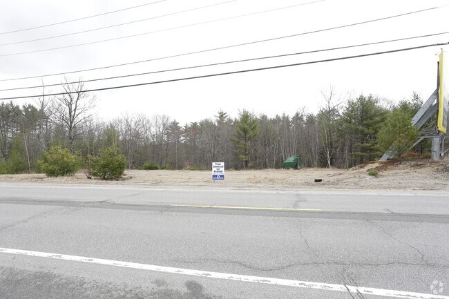
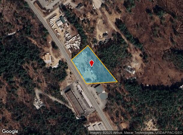
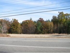
Property Record
673 White Mountain Hwy, Chocorua, NH 03817
NEARBY LISTINGS FOR SALE OR LEASE
-
-
View all Chocorua listings for sale on LoopNet.com
Property Detail
673 White Mountain Hwy
Multipleuses
Carroll
X
New Hampshire
33003C0480D
1.90 AC
2024
Concord/New Hampshire North Area
2024
Other Market Areas
955602
TAMW-000217-000034
DEMOGRAPHICS near 673 White Mountain Hwy
1 Mile
3 Mile
5 Mile
2024 Total Population
225
2,409
3,799
2029 Population
238
2,552
4,048
Pop Growth 2024-2029
+ 5.78%
+ 5.94%
+ 6.55%
Average Age
47
48
48
2024 Total Households
103
1,109
1,741
HH Growth 2024-2029
+ 4.85%
+ 5.59%
+ 6.26%
Median Household Inc
$59,999
$66,823
$66,721
Avg Household Size
2.20
2.10
2.20
2024 Avg HH Vehicles
2.00
2.00
2.00
Median Home Value
$287,999
$305,138
$301,444
Median Year Built
1975
1975
1976
Nearby Places
Map Layers
Map Styles
 Street
 Aerial
- Restaurants
- Banks
- Shops
- Fitness
- Groceries
SALE & LEASE HISTORY
LISTING DATE
SALE/LEASE

May 25, 2018
For Sale
Nearby Properties
Address
Land Use
TOTAL SIZE
Lot Size
Zoning
Address
Land Use
TOTAL SIZE
Lot Size
Zoning
1,421 SF
TAMWOR
Address
Land Use
TOTAL SIZE
Lot Size
Zoning
1,628 SF
902.70 AC
TAMWOR
Address
Land Use
TOTAL SIZE
Lot Size
Zoning
2,022 SF
51.77 AC
COMMER
Address
Land Use
TOTAL SIZE
Lot Size
Zoning
11,546 SF
5.11 AC
TAMWOR
Address
Land Use
TOTAL SIZE
Lot Size
Zoning
22,103 SF
5.59 AC
COM
Address
Land Use
TOTAL SIZE
Lot Size
Zoning
3,054 SF
10.17 AC
TAMWOR
Address
Land Use
TOTAL SIZE
Lot Size
Zoning
19,271 SF
8 AC
RSC
Address
Land Use
TOTAL SIZE
Lot Size
Zoning
15,257 SF
3.50 AC
RSC
Address
Land Use
TOTAL SIZE
Lot Size
Zoning
633 SF
6.90 AC
TAMWOR
Address
Land Use
TOTAL SIZE
Lot Size
Zoning
3,764 SF
274 AC
TAMWOR
Address
Land Use
TOTAL SIZE
Lot Size
Zoning
11,220 SF
2.40 AC
COM
Address
Land Use
TOTAL SIZE
Lot Size
Zoning
1,298 SF
2.86 AC
TAMWOR
Address
Land Use
TOTAL SIZE
Lot Size
Zoning
1,720 SF
186.40 AC
TAMWOR
Address
Land Use
TOTAL SIZE
Lot Size
Zoning
3,534 SF
2.10 AC
TAMWOR
Address
Land Use
TOTAL SIZE
Lot Size
Zoning
38 AC
TAMWOR
Address
Land Use
TOTAL SIZE
Lot Size
Zoning
19,068 SF
2.50 AC
COMMER
Address
Land Use
TOTAL SIZE
Lot Size
Zoning
10,730 SF
7.07 AC
TAMWOR
Address
Land Use
TOTAL SIZE
Lot Size
Zoning
0.59 AC
TAMWOR
Address
Land Use
TOTAL SIZE
Lot Size
Zoning
28,588 SF
2.50 AC
TAMWOR
Address
Land Use
TOTAL SIZE
Lot Size
Zoning
7,085 SF
48 AC
TAMWOR
Address
Land Use
TOTAL SIZE
Lot Size
Zoning
3,000 SF
5.34 AC
TAMWOR
Address
Land Use
TOTAL SIZE
Lot Size
Zoning
5,089 SF
9.91 AC
TAMWOR
Address
Land Use
TOTAL SIZE
Lot Size
Zoning
253 SF
4.25 AC
RURAL
Address
Land Use
TOTAL SIZE
Lot Size
Zoning
927 SF
5.17 AC
TAMWOR
Address
Land Use
TOTAL SIZE
Lot Size
Zoning
6,000 SF
4 AC
TAMWOR
Address
Land Use
TOTAL SIZE
Lot Size
Zoning
3,962 SF
0.63 AC
RSC
Address
Land Use
TOTAL SIZE
Lot Size
Zoning
9,360 SF
1.30 AC
TAMWOR
Address
Land Use
TOTAL SIZE
Lot Size
Zoning
8,067 SF
68 AC
RURAL
Address
Land Use
TOTAL SIZE
Lot Size
Zoning
54.98 AC
TAMWOR
Address
Land Use
TOTAL SIZE
Lot Size
Zoning
2,028 SF
27.70 AC
TAMWOR
The World's #1 Commercial Real Estate Marketplace
Connect with us
© 2025 CoStar Group
The information above has been obtained from sources believed reliable. While we do not doubt its accuracy we have not verified it and make no guarantee, warranty or representation about it. It is your responsibility to independently confirm its accuracy and completeness. Any projections, opinions, assumptions, or estimates used are for example only and do not represent the current or future performance of the property. The value of this transaction to you depends on tax and other factors which should be evaluated by your tax, financial, and legal advisors. You and your advisors should conduct a careful, independent investigation of the property to determine to your satisfaction the suitability of the property for your needs.