Property Record
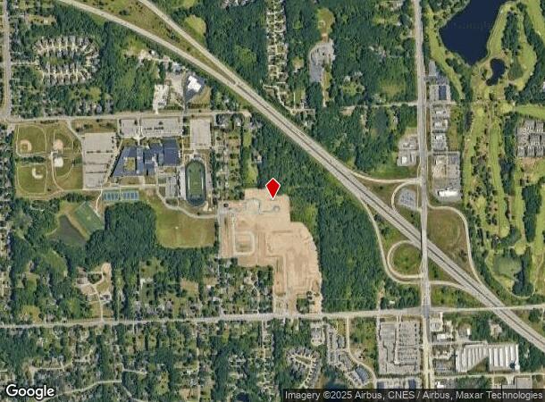
6730 Walters Rd, Clarkston, MI 48346
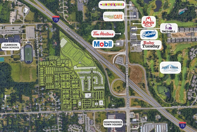
NEARBY LISTINGS FOR SALE OR LEASE
Property Detail
6730 Walters Rd
08-22-351-011
T4N, R9E, SEC 22 PART OF W 1/2 OF SW 1/4 BEG AT PT DIST S 01-46-30 W 1136.93 FT FROM W 1/4 COR, TH S 88-34-40 E 333 FT, TH N
Commercialacreage
Oakland
X
Michigan
26125C0332F
9.56 AC
2021
Lakes Area
2021
Detroit
127500
Detroit-Warren-Dearborn, MI
DEMOGRAPHICS near 6730 Walters Rd
1 Mile
3 Mile
5 Mile
2024 Total Population
4,461
34,772
88,050
2029 Population
4,416
34,407
87,184
Pop Growth 2024-2029
(1.01%)
(1.05%)
(0.98%)
Average Age
42
42
42
2024 Total Households
1,811
13,687
34,662
HH Growth 2024-2029
(1.21%)
(1.18%)
(1.07%)
Median Household Inc
$100,293
$97,669
$93,256
Avg Household Size
2.50
2.50
2.50
2024 Avg HH Vehicles
2.00
2.00
2.00
Median Home Value
$330,229
$325,249
$296,179
Median Year Built
1990
1979
1978
Nearby Places
Map Layers
Map Styles
 Street
 Aerial
- Restaurants
- Banks
- Shops
- Fitness
- Groceries
PUBLIC TRANSPORTATION
AIRPORT
Bishop International
DRIVE
WALK
Distance
Bishop International
46 min
30.5 mi
Freight Ports
Port of Toledo
DRIVE
WALK
Distance
Port of Toledo
116 min
87.8 mi
SALE & LEASE HISTORY
LISTING DATE
SALE/LEASE

Oct 17, 2019
For Sale
Nearby Properties
Address
Land Use
TOTAL SIZE
Lot Size
Zoning
Address
Land Use
TOTAL SIZE
Lot Size
Zoning
138,009 SF
8.03 AC
PUD
Address
Land Use
TOTAL SIZE
Lot Size
Zoning
388,304 SF
69.09 AC
R2
Address
Land Use
TOTAL SIZE
Lot Size
Zoning
327,435 SF
39.93 AC
R2
Address
Land Use
TOTAL SIZE
Lot Size
Zoning
17.63 AC
R3
Address
Land Use
TOTAL SIZE
Lot Size
Zoning
208,006 SF
1.24 AC
R2
Address
Land Use
TOTAL SIZE
Lot Size
Zoning
64,763 SF
27.90 AC
PUD
Address
Land Use
TOTAL SIZE
Lot Size
Zoning
68,725 SF
4.96 AC
PUD
Address
Land Use
TOTAL SIZE
Lot Size
Zoning
34,335 SF
74.71 AC
REC
Address
Land Use
TOTAL SIZE
Lot Size
Zoning
249,200 SF
48.39 AC
R2
Address
Land Use
TOTAL SIZE
Lot Size
Zoning
327,288 SF
19.85 AC
R2
Address
Land Use
TOTAL SIZE
Lot Size
Zoning
78,261 SF
7.80 AC
PUD
Address
Land Use
TOTAL SIZE
Lot Size
Zoning
63,331 SF
10.03 AC
R2
Address
Land Use
TOTAL SIZE
Lot Size
Zoning
44.10 AC
PUD
Address
Land Use
TOTAL SIZE
Lot Size
Zoning
35,155 SF
87.55 AC
REC
Address
Land Use
TOTAL SIZE
Lot Size
Zoning
120,673 SF
9.40 AC
IOP
Address
Land Use
TOTAL SIZE
Lot Size
Zoning
9,768 SF
25.89 AC
PUD
Address
Land Use
TOTAL SIZE
Lot Size
Zoning
87,130 SF
9.01 AC
C-3
Address
Land Use
TOTAL SIZE
Lot Size
Zoning
Address
Land Use
TOTAL SIZE
Lot Size
Zoning
33,365 SF
320.73 AC
PRD
Address
Land Use
TOTAL SIZE
Lot Size
Zoning
327,288 SF
29.09 AC
REC
Address
Land Use
TOTAL SIZE
Lot Size
Zoning
151,736 SF
26.03 AC
C-2
Address
Land Use
TOTAL SIZE
Lot Size
Zoning
49,169 SF
5.02 AC
PUD
Address
Land Use
TOTAL SIZE
Lot Size
Zoning
48,645 SF
6.68 AC
PUD
Address
Land Use
TOTAL SIZE
Lot Size
Zoning
111,760 SF
29.33 AC
R2
Address
Land Use
TOTAL SIZE
Lot Size
Zoning
117,980 SF
11.33 AC
IOP
Address
Land Use
TOTAL SIZE
Lot Size
Zoning
44,915 SF
0.47 AC
PUD
Address
Land Use
TOTAL SIZE
Lot Size
Zoning
31,068 SF
3 AC
PUD
Address
Land Use
TOTAL SIZE
Lot Size
Zoning
2,646 SF
27.22 AC
RMT
Address
Land Use
TOTAL SIZE
Lot Size
Zoning
739 SF
5.36 AC
R1A
Address
Land Use
TOTAL SIZE
Lot Size
Zoning
107,635 SF
8.12 AC
BI
The World's #1 Commercial Real Estate Marketplace
Connect with us
© 2025 CoStar Group
The information above has been obtained from sources believed reliable. While we do not doubt its accuracy we have not verified it and make no guarantee, warranty or representation about it. It is your responsibility to independently confirm its accuracy and completeness. Any projections, opinions, assumptions, or estimates used are for example only and do not represent the current or future performance of the property. The value of this transaction to you depends on tax and other factors which should be evaluated by your tax, financial, and legal advisors. You and your advisors should conduct a careful, independent investigation of the property to determine to your satisfaction the suitability of the property for your needs.