Property Record
6737 Walnut St, Frisco, TX 75033
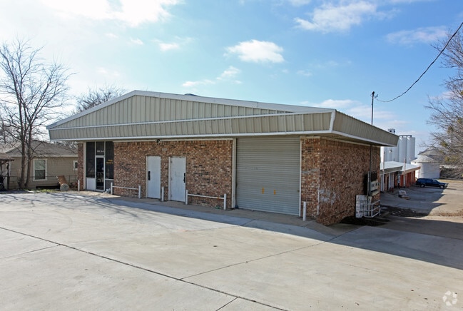


Property Detail
6737 Walnut St
Dallas-Fort Worth-Arlington, TX
Frisco Original Donation (Cfr)
R-0982-063-0190-1
FRISCO ORIGINAL DONATION, BLK 63, LOT 13B-18B & 19-24
Commercialnec
Collin
X
Texas
48085C0240K
13b-1
2024
0.75 AC
2025
Frisco
021526
Dallas/Ft Worth
13,053 SF
NEARBY LISTINGS FOR SALE OR LEASE
DEMOGRAPHICS near 6737 Walnut St
1 mile
3 mile
5 mile
2024 Total Population
9,213
101,427
297,261
2029 Population
11,563
124,049
362,853
Pop Growth 2024-2029
+ 25.51%
+ 22.30%
+ 22.07%
Average Age
37
37
36
2024 Total Households
4,138
37,579
103,841
HH Growth 2024-2029
+ 26.29%
+ 23.05%
+ 22.61%
Median Household Inc
$68,547
$113,723
$124,607
Avg Household Size
2.20
2.70
2.80
2024 Avg HH Vehicles
2.00
2.00
2.00
Median Home Value
$344,431
$473,324
$465,507
Median Year Built
2007
2006
2008
Nearby Places
Map Layers
Map Styles
 Street
 Aerial
Transit
 Traffic
 Biking
Places
Listings with unknown addresses are not visible on the map
- Restaurants
- Banks
- Shops
- Fitness
- Groceries
PUBLIC TRANSPORTATION
AIRPORT
Dallas Love Field
Drive
Walk
Distance
Dallas Love Field
35 min
25.2 mi
Dallas-Fort Worth International
Drive
Walk
Distance
Dallas-Fort Worth International
34 min
26.1 mi
SALE & LEASE HISTORY
LISTING DATE
SALE/LEASE

Oct 26, 2016
For Lease
Nearby Properties
Address
Land Use
TOTAL SIZE
Lot Size
Zoning
Address
Land Use
TOTAL SIZE
Lot Size
Zoning
525,388 SF
5.01 AC
Address
Land Use
TOTAL SIZE
Lot Size
Zoning
343,317 SF
17.17 AC
Address
Land Use
TOTAL SIZE
Lot Size
Zoning
358,447 SF
40.21 AC
Address
Land Use
TOTAL SIZE
Lot Size
Zoning
975,081 SF
15.33 AC
Address
Land Use
TOTAL SIZE
Lot Size
Zoning
525,405 SF
5.09 AC
Address
Land Use
TOTAL SIZE
Lot Size
Zoning
741,280 SF
90.87 AC
Address
Land Use
TOTAL SIZE
Lot Size
Zoning
358,496 SF
2.49 AC
Address
Land Use
TOTAL SIZE
Lot Size
Zoning
325,179 SF
4.74 AC
COMM
Address
Land Use
TOTAL SIZE
Lot Size
Zoning
458,757 SF
83.22 AC
Address
Land Use
TOTAL SIZE
Lot Size
Zoning
761,346 SF
75.86 AC
Address
Land Use
TOTAL SIZE
Lot Size
Zoning
325,000 SF
47.61 AC
Address
Land Use
TOTAL SIZE
Lot Size
Zoning
556,032 SF
24.46 AC
MF-M
Address
Land Use
TOTAL SIZE
Lot Size
Zoning
489,385 SF
10.24 AC
Address
Land Use
TOTAL SIZE
Lot Size
Zoning
492,430 SF
6.66 AC
MF-E
Address
Land Use
TOTAL SIZE
Lot Size
Zoning
369,122 SF
3.06 AC
MF-R
Address
Land Use
TOTAL SIZE
Lot Size
Zoning
431,308 SF
4.28 AC
COMM
Address
Land Use
TOTAL SIZE
Lot Size
Zoning
236,513 SF
99.95 AC
Address
Land Use
TOTAL SIZE
Lot Size
Zoning
417,369 SF
5.65 AC
MF-E
Address
Land Use
TOTAL SIZE
Lot Size
Zoning
329,460 SF
63.31 AC
Address
Land Use
TOTAL SIZE
Lot Size
Zoning
304,601 SF
6.11 AC
Address
Land Use
TOTAL SIZE
Lot Size
Zoning
352,470 SF
96.59 AC
Address
Land Use
TOTAL SIZE
Lot Size
Zoning
138.63 AC
Address
Land Use
TOTAL SIZE
Lot Size
Zoning
438,092 SF
6.32 AC
Address
Land Use
TOTAL SIZE
Lot Size
Zoning
493,823 SF
2.44 AC
Address
Land Use
TOTAL SIZE
Lot Size
Zoning
448,026 SF
4.84 AC
Address
Land Use
TOTAL SIZE
Lot Size
Zoning
533,937 SF
17.44 AC
MF-M
Address
Land Use
TOTAL SIZE
Lot Size
Zoning
510,032 SF
7.47 AC
Address
Land Use
TOTAL SIZE
Lot Size
Zoning
346,252 SF
11.32 AC
Address
Land Use
TOTAL SIZE
Lot Size
Zoning
386,806 SF
22.59 AC
Address
Land Use
TOTAL SIZE
Lot Size
Zoning
410,262 SF
20.90 AC
MF-M
The World's #1 Commercial Real Estate Marketplace
Connect with us
© 2026 CoStar Group
The information above has been obtained from sources believed reliable. While we do not doubt its accuracy we have not verified it and make no guarantee, warranty or representation about it. It is your responsibility to independently confirm its accuracy and completeness. Any projections, opinions, assumptions, or estimates used are for example only and do not represent the current or future performance of the property. The value of this transaction to you depends on tax and other factors which should be evaluated by your tax, financial, and legal advisors. You and your advisors should conduct a careful, independent investigation of the property to determine to your satisfaction the suitability of the property for your needs.