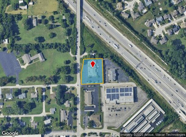
Property Record
6745 Gray Rd, Indianapolis, IN 46237
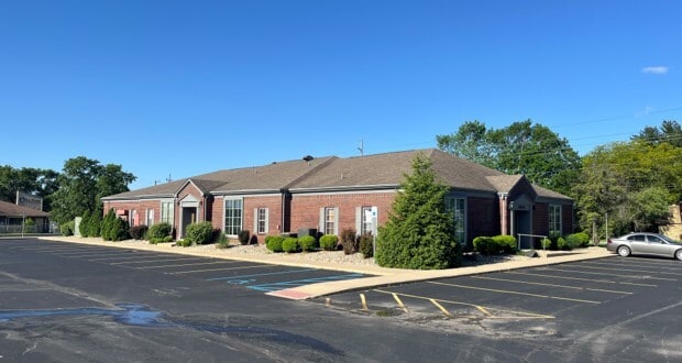
This Property Is For Sale
NEARBY LISTINGS FOR SALE OR LEASE
Property Detail
6745 Gray Rd
49-15-09-130-003.000-500
PT SE1/4 SW1/4 S9 T14 R4 BEG 1093.3FT N OF SW CORN 118FT E 25FT NE 101.98FT NE 34.87FT E188FT S 250.24FT W 243.8FT TO BEG 1.28AC
Officebuilding
Marion
X
Indiana
18097C0261G
1.28 AC
2023
Edgewood/South County
2024
Indianapolis
380902
Indianapolis-Carmel-Anderson, IN
8,878 SF
DEMOGRAPHICS near 6745 Gray Rd
1 Mile
3 Mile
5 Mile
2024 Total Population
7,263
84,482
207,309
2029 Population
7,133
83,343
207,131
Pop Growth 2024-2029
(1.79%)
(1.35%)
(0.09%)
Average Age
40
38
38
2024 Total Households
2,922
33,388
80,653
HH Growth 2024-2029
(1.81%)
(1.32%)
+ 0.01%
Median Household Inc
$74,186
$63,891
$66,575
Avg Household Size
2.40
2.50
2.50
2024 Avg HH Vehicles
2.00
2.00
2.00
Median Home Value
$224,467
$188,402
$191,078
Median Year Built
1991
1979
1979
Nearby Places
- Restaurants
- Banks
- Shops
- Fitness
- Groceries
PUBLIC TRANSPORTATION
COMMUTER RAIL
Indianapolis (Cardinal - Amtrak)
DRIVE
WALK
Distance
Indianapolis (Cardinal - Amtrak)
14 min
9.5 mi
AIRPORT
Indianapolis International
DRIVE
WALK
Distance
Indianapolis International
34 min
20.4 mi
Freight Ports
Port of Toledo
DRIVE
WALK
Distance
Port of Toledo
277 min
231.8 mi
Nearby Properties
Address
Land Use
TOTAL SIZE
Lot Size
Zoning
Address
Land Use
TOTAL SIZE
Lot Size
Zoning
295,161 SF
70.54 AC
Address
Land Use
TOTAL SIZE
Lot Size
Zoning
31,217 SF
105.06 AC
ZO01
Address
Land Use
TOTAL SIZE
Lot Size
Zoning
5,846 SF
43.64 AC
ZO01
Address
Land Use
TOTAL SIZE
Lot Size
Zoning
3,586 SF
30.28 AC
ZO01
Address
Land Use
TOTAL SIZE
Lot Size
Zoning
5,576 SF
14.15 AC
ZO01
Address
Land Use
TOTAL SIZE
Lot Size
Zoning
3,286 SF
26.39 AC
Address
Land Use
TOTAL SIZE
Lot Size
Zoning
81,996 SF
8.56 AC
Address
Land Use
TOTAL SIZE
Lot Size
Zoning
19,927 SF
28.82 AC
ZO01
Address
Land Use
TOTAL SIZE
Lot Size
Zoning
181,458 SF
6 AC
Address
Land Use
TOTAL SIZE
Lot Size
Zoning
6,786 SF
45.81 AC
Address
Land Use
TOTAL SIZE
Lot Size
Zoning
1,362 SF
6.66 AC
ZO01
Address
Land Use
TOTAL SIZE
Lot Size
Zoning
3,782 SF
44.43 AC
ZO01
Address
Land Use
TOTAL SIZE
Lot Size
Zoning
21,784 SF
30.75 AC
ZO01
Address
Land Use
TOTAL SIZE
Lot Size
Zoning
5,401 SF
21.94 AC
ZO01
Address
Land Use
TOTAL SIZE
Lot Size
Zoning
2,911 SF
24.62 AC
ZO01
Address
Land Use
TOTAL SIZE
Lot Size
Zoning
226,129 SF
18.69 AC
ZO01
Address
Land Use
TOTAL SIZE
Lot Size
Zoning
110,598 SF
22.82 AC
ZO01
Address
Land Use
TOTAL SIZE
Lot Size
Zoning
1,102 SF
9.98 AC
Address
Land Use
TOTAL SIZE
Lot Size
Zoning
352,000 SF
22.72 AC
ZO01
Address
Land Use
TOTAL SIZE
Lot Size
Zoning
155,088 SF
20.85 AC
ZO01
Address
Land Use
TOTAL SIZE
Lot Size
Zoning
3,935 SF
36.09 AC
ZO01
Address
Land Use
TOTAL SIZE
Lot Size
Zoning
2,320 SF
7.92 AC
ZO01
Address
Land Use
TOTAL SIZE
Lot Size
Zoning
4,476 SF
12.18 AC
Address
Land Use
TOTAL SIZE
Lot Size
Zoning
3,296 SF
21 AC
Address
Land Use
TOTAL SIZE
Lot Size
Zoning
3,202 SF
18.62 AC
ZO01
Address
Land Use
TOTAL SIZE
Lot Size
Zoning
3,701 SF
26 AC
ZO01
Address
Land Use
TOTAL SIZE
Lot Size
Zoning
37,718 SF
11.77 AC
ZO01
Address
Land Use
TOTAL SIZE
Lot Size
Zoning
73,680 SF
5.62 AC
ZO01
Address
Land Use
TOTAL SIZE
Lot Size
Zoning
1,960 SF
23.76 AC
Address
Land Use
TOTAL SIZE
Lot Size
Zoning
88,694 SF
11.81 AC
ZO01
The World's #1 Commercial Real Estate Marketplace
Connect with us
© 2025 CoStar Group
The information above has been obtained from sources believed reliable. While we do not doubt its accuracy we have not verified it and make no guarantee, warranty or representation about it. It is your responsibility to independently confirm its accuracy and completeness. Any projections, opinions, assumptions, or estimates used are for example only and do not represent the current or future performance of the property. The value of this transaction to you depends on tax and other factors which should be evaluated by your tax, financial, and legal advisors. You and your advisors should conduct a careful, independent investigation of the property to determine to your satisfaction the suitability of the property for your needs.