Property Record
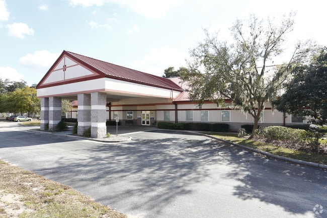
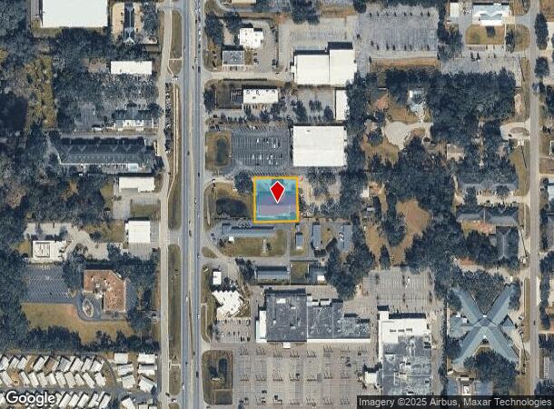
6748 Gall Blvd, Zephyrhills, FL 33542


NEARBY LISTINGS FOR SALE OR LEASE
Property Detail
6748 Gall Blvd
Tampa-St. Petersburg-Clearwater, FL
Zephyrhills Colony Company
02-26-21-0010-02500-0020
ZEPHYRHILLS COLONY COMPANY LANDS PB 1 PG 55 NORTH 1/2 OF TRACT 25 LYING EAST OF US 301 LESS EAST 230 FT THEREOF & LESS WEST 160 FT OF NORTH 1/2 LYING EAST OF US 301 OR 8021 PG 206
Officebuilding
Pasco
X
Florida
12101C0293F
2
0
0.66 AC
2025
Pasco County
032804
Tampa/St Petersburg
11,546 SF
DEMOGRAPHICS near 6748 Gall Blvd
1 Mile
3 Mile
5 Mile
2024 Total Population
10,304
47,652
75,173
2029 Population
12,534
57,837
91,578
Pop Growth 2024-2029
+ 21.64%
+ 21.37%
+ 21.82%
Average Age
50
49
49
2024 Total Households
4,948
21,833
33,768
HH Growth 2024-2029
+ 21.60%
+ 21.44%
+ 21.82%
Median Household Inc
$42,041
$41,978
$45,597
Avg Household Size
2.00
2.10
2.20
2024 Avg HH Vehicles
1.00
2.00
2.00
Median Home Value
$140,237
$123,987
$125,250
Median Year Built
1987
1984
1988
Nearby Places
Map Layers
Map Styles
 Street
 Aerial
- Restaurants
- Banks
- Shops
- Fitness
- Groceries
PUBLIC TRANSPORTATION
AIRPORT
Tampa International
DRIVE
WALK
Distance
Tampa International
56 min
38.0 mi
Freight Ports
Port of Tampa Bay
DRIVE
WALK
Distance
Port of Tampa Bay
49 min
31.4 mi
SALE & LEASE HISTORY
LISTING DATE
SALE/LEASE

Feb 14, 2022
For Lease
Nearby Properties
Address
Land Use
TOTAL SIZE
Lot Size
Zoning
Address
Land Use
TOTAL SIZE
Lot Size
Zoning
245,602 SF
12.57 AC
MPUD
Address
Land Use
TOTAL SIZE
Lot Size
Zoning
273,092 SF
12.29 AC
R4
Address
Land Use
TOTAL SIZE
Lot Size
Zoning
352,321 SF
27.88 AC
OP
Address
Land Use
TOTAL SIZE
Lot Size
Zoning
610,631 SF
45.79 AC
LI
Address
Land Use
TOTAL SIZE
Lot Size
Zoning
199,367 SF
15.46 AC
R2
Address
Land Use
TOTAL SIZE
Lot Size
Zoning
162,278 SF
118.82 AC
AP2
Address
Land Use
TOTAL SIZE
Lot Size
Zoning
107,232 SF
12.79 AC
MPUD
Address
Land Use
TOTAL SIZE
Lot Size
Zoning
292,589 SF
52.57 AC
R3
Address
Land Use
TOTAL SIZE
Lot Size
Zoning
88,782 SF
4.09 AC
M1
Address
Land Use
TOTAL SIZE
Lot Size
Zoning
91,192 SF
3.40 AC
C2
Address
Land Use
TOTAL SIZE
Lot Size
Zoning
98,980 SF
5.36 AC
C2
Address
Land Use
TOTAL SIZE
Lot Size
Zoning
41,812 SF
255.72 AC
AP2
Address
Land Use
TOTAL SIZE
Lot Size
Zoning
216,202 SF
23.77 AC
C2
Address
Land Use
TOTAL SIZE
Lot Size
Zoning
68,446 SF
3.54 AC
C2
Address
Land Use
TOTAL SIZE
Lot Size
Zoning
79,605 SF
3.13 AC
C2
Address
Land Use
TOTAL SIZE
Lot Size
Zoning
105,449 SF
5.14 AC
OP
Address
Land Use
TOTAL SIZE
Lot Size
Zoning
101.06 AC
MPUD
Address
Land Use
TOTAL SIZE
Lot Size
Zoning
60,759 SF
7.56 AC
C2
Address
Land Use
TOTAL SIZE
Lot Size
Zoning
32,076 SF
3.58 AC
PUD
Address
Land Use
TOTAL SIZE
Lot Size
Zoning
107,022 SF
13.27 AC
C2
Address
Land Use
TOTAL SIZE
Lot Size
Zoning
56,312 SF
8.85 AC
PUD
Address
Land Use
TOTAL SIZE
Lot Size
Zoning
94,412 SF
9.67 AC
C2
Address
Land Use
TOTAL SIZE
Lot Size
Zoning
62,320 SF
8.13 AC
R4
Address
Land Use
TOTAL SIZE
Lot Size
Zoning
76,015 SF
9.18 AC
C2
Address
Land Use
TOTAL SIZE
Lot Size
Zoning
143,626 SF
11.13 AC
R4
Address
Land Use
TOTAL SIZE
Lot Size
Zoning
61,636 SF
6.84 AC
C2
Address
Land Use
TOTAL SIZE
Lot Size
Zoning
131,274 SF
13.07 AC
R4
Address
Land Use
TOTAL SIZE
Lot Size
Zoning
123,959 SF
15.18 AC
C2
Address
Land Use
TOTAL SIZE
Lot Size
Zoning
72,183 SF
42.44 AC
R3
Address
Land Use
TOTAL SIZE
Lot Size
Zoning
67,222 SF
7.96 AC
C2
The World's #1 Commercial Real Estate Marketplace
Connect with us
© 2025 CoStar Group
The information above has been obtained from sources believed reliable. While we do not doubt its accuracy we have not verified it and make no guarantee, warranty or representation about it. It is your responsibility to independently confirm its accuracy and completeness. Any projections, opinions, assumptions, or estimates used are for example only and do not represent the current or future performance of the property. The value of this transaction to you depends on tax and other factors which should be evaluated by your tax, financial, and legal advisors. You and your advisors should conduct a careful, independent investigation of the property to determine to your satisfaction the suitability of the property for your needs.