Property Record
675 S Fulton St, Salt Lake City, UT 84104
NEARBY LISTINGS FOR SALE OR LEASE
Property Detail
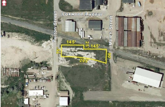
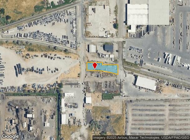
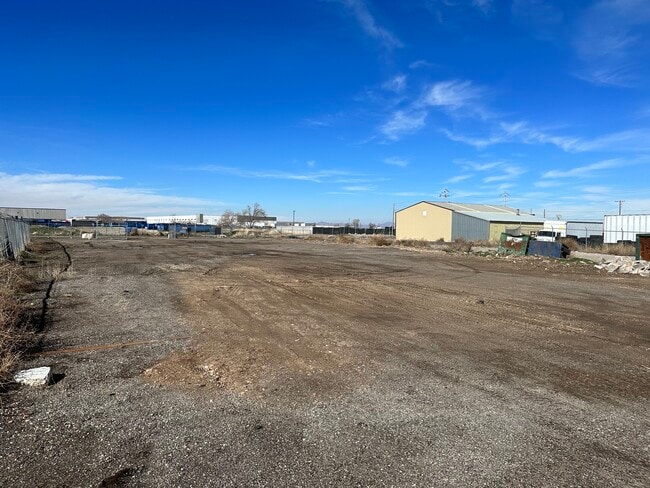
675 S Fulton St
Salt Lake City, UT
Buena Vista Sub
15-09-126-004-0000
BEG NW COR OF LOT 25, BLK 1, BUENA VISTA SUB; S 0^1759 E 75.86 FT; N 89^4201 E 39.50 FT; SELY ALG A 772 FT RADIUS CURVE TO R 216.25 FT; S 74^15 E 41.95 FT TO E LINE OF LOT 6; N 0^1759 W 91.41 FT; S 89^5527 W 146.625 FT; N 0^1759 W 25 FT; S 89^5527 W
Industrialacreage
Salt Lake
X
Utah
49011C0525E
25
2024
0.51 AC
2025
West Valley/Lake Park
114500
Salt Lake City
DEMOGRAPHICS near 675 S Fulton St
1 Mile
3 Mile
5 Mile
2024 Total Population
3
47,017
194,321
2029 Population
3
47,516
197,691
Pop Growth 2024-2029
0.00%
+ 1.06%
+ 1.73%
Average Age
0
35
36
2024 Total Households
1
15,460
76,697
HH Growth 2024-2029
0.00%
+ 1.25%
+ 2.34%
Median Household Inc
$0
$55,702
$57,899
Avg Household Size
.00
2.80
2.40
2024 Avg HH Vehicles
.00
2.00
2.00
Median Home Value
$0
$299,020
$348,705
Median Year Built
0
1974
1978
Nearby Places
Map Layers
Map Styles
 Street
 Aerial
- Restaurants
- Banks
- Shops
- Fitness
- Groceries
PUBLIC TRANSPORTATION
COMMUTER RAIL
North Temple Station (FrontRunner - Utah Transit Authority (UTA))
DRIVE
WALK
Distance
North Temple Station (FrontRunner - Utah Transit Authority (UTA))
11 min
4.4 mi
Warm Springs Relief Point (FrontRunner - Utah Transit Authority (UTA))
DRIVE
WALK
Distance
Warm Springs Relief Point (FrontRunner - Utah Transit Authority (UTA))
12 min
5.6 mi
AIRPORT
Salt Lake City International
DRIVE
WALK
Distance
Salt Lake City International
11 min
5.6 mi
Freight Ports
Port of Stockton
DRIVE
WALK
Distance
Port of Stockton
712 min
696.1 mi
SALE & LEASE HISTORY
LISTING DATE
SALE/LEASE

Feb 19, 2024
For Lease
Nearby Properties
Address
Land Use
TOTAL SIZE
Lot Size
Zoning
Address
Land Use
TOTAL SIZE
Lot Size
Zoning
427,316 SF
12.31 AC
AIRPRT
Address
Land Use
TOTAL SIZE
Lot Size
Zoning
1,523,947 SF
37.63 AC
AIR
Address
Land Use
TOTAL SIZE
Lot Size
Zoning
186,429 SF
101 AC
AIRPRT
Address
Land Use
TOTAL SIZE
Lot Size
Zoning
691,465 SF
18.57 AC
3000
Address
Land Use
TOTAL SIZE
Lot Size
Zoning
22,022 SF
308 AC
AIRPRT
Address
Land Use
TOTAL SIZE
Lot Size
Zoning
248,345 SF
50 AC
PL
Address
Land Use
TOTAL SIZE
Lot Size
Zoning
252,420 SF
15.26 AC
TSA-MU
Address
Land Use
TOTAL SIZE
Lot Size
Zoning
690,542 SF
35.75 AC
M-1
Address
Land Use
TOTAL SIZE
Lot Size
Zoning
86,072 SF
240 AC
AIRPOR
Address
Land Use
TOTAL SIZE
Lot Size
Zoning
146,652 SF
16.63 AC
RMF-45
Address
Land Use
TOTAL SIZE
Lot Size
Zoning
322,076 SF
16.32 AC
PL
Address
Land Use
TOTAL SIZE
Lot Size
Zoning
434,985 SF
74.85 AC
AIRPOR
Address
Land Use
TOTAL SIZE
Lot Size
Zoning
243,202 SF
18.71 AC
BP
Address
Land Use
TOTAL SIZE
Lot Size
Zoning
171,839 SF
17.80 AC
CG
Address
Land Use
TOTAL SIZE
Lot Size
Zoning
77,693 SF
2.99 AC
TSA-MU
Address
Land Use
TOTAL SIZE
Lot Size
Zoning
429,554 SF
24.49 AC
M1
Address
Land Use
TOTAL SIZE
Lot Size
Zoning
127,348 SF
4.55 AC
BP
Address
Land Use
TOTAL SIZE
Lot Size
Zoning
505,079 SF
30.07 AC
M-1
Address
Land Use
TOTAL SIZE
Lot Size
Zoning
7,180 SF
285.05 AC
AIRPRT
Address
Land Use
TOTAL SIZE
Lot Size
Zoning
1,932 SF
33.44 AC
TSAMUC
Address
Land Use
TOTAL SIZE
Lot Size
Zoning
482,870 SF
31.13 AC
M-1
Address
Land Use
TOTAL SIZE
Lot Size
Zoning
505,800 SF
23.87 AC
M-1
Address
Land Use
TOTAL SIZE
Lot Size
Zoning
11,040 SF
175.57 AC
AIRPRT
Address
Land Use
TOTAL SIZE
Lot Size
Zoning
475,592 SF
24.09 AC
M-1
Address
Land Use
TOTAL SIZE
Lot Size
Zoning
232,795 SF
2.57 AC
GMU
Address
Land Use
TOTAL SIZE
Lot Size
Zoning
319,914 SF
1.24 AC
GMU
Address
Land Use
TOTAL SIZE
Lot Size
Zoning
120 AC
AIRPOR
Address
Land Use
TOTAL SIZE
Lot Size
Zoning
426,280 SF
19.84 AC
M1
Address
Land Use
TOTAL SIZE
Lot Size
Zoning
491,507 SF
28.28 AC
M-1
Address
Land Use
TOTAL SIZE
Lot Size
Zoning
116,268 SF
8.07 AC
RMF-45
The World's #1 Commercial Real Estate Marketplace
Connect with us
© 2025 CoStar Group
The information above has been obtained from sources believed reliable. While we do not doubt its accuracy we have not verified it and make no guarantee, warranty or representation about it. It is your responsibility to independently confirm its accuracy and completeness. Any projections, opinions, assumptions, or estimates used are for example only and do not represent the current or future performance of the property. The value of this transaction to you depends on tax and other factors which should be evaluated by your tax, financial, and legal advisors. You and your advisors should conduct a careful, independent investigation of the property to determine to your satisfaction the suitability of the property for your needs.