Property Record
675 Gateway Blvd, Monroe, OH 45050


Save to a Folder
{{folder.Name}}
{{folder.ListingIds.length}} Properties
{{folder.ListingIds.length}} Property
Create a New Folder
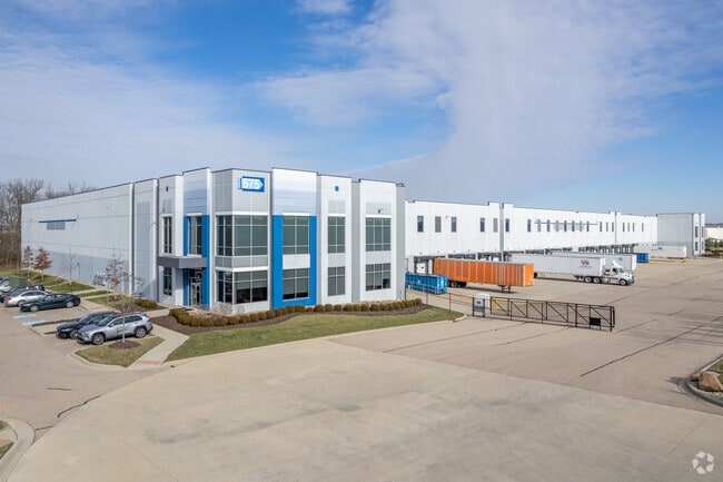
Property Detail
675 Gateway Blvd
Cincinnati, OH-KY-IN
PARK NORTH PHASE 5 LOT 5B
11-05-300-019-1
WARREN
Industrialgeneral
Ohio
AE The base floodplain where base flood elevations are provided. AE Zones are now used on new format FIRMs instead of A1-A30 Zones.
5b
2024
8.08 AC
2025
Monroe/Middletown
031601
Cincinnati/Dayton
NEARBY LISTINGS FOR SALE OR LEASE
DEMOGRAPHICS near 675 Gateway Blvd
1 mile
3 mile
5 mile
2025 Total Population
575
23,640
79,537
2030 Population
586
24,362
82,418
Pop Growth 2025-2030
+ 1.91%
+ 3.05%
+ 3.62%
Average Age
37
39
39
2025 Total Households
205
7,449
27,703
HH Growth 2025-2030
+ 1.95%
+ 3.41%
+ 3.76%
Median Household Inc
$118,269
$120,166
$110,697
Avg Household Size
2.80
2.80
2.70
2025 Avg HH Vehicles
2.00
2.00
2.00
Median Home Value
$317,647
$390,465
$399,146
Median Year Built
1996
1999
1998
Nearby Places
Map Layers
Map Styles
 Street
 Aerial
Layers
 Traffic
 Biking
Places
Listings with unknown addresses are not visible on the map
- Restaurants
- Banks
- Shops
- Fitness
- Groceries
PUBLIC TRANSPORTATION
AIRPORT
James M Cox Dayton International
Drive
Walk
Distance
James M Cox Dayton International
55 min
39.1 mi
Cincinnati/Northern Kentucky International
Drive
Walk
Distance
Cincinnati/Northern Kentucky International
67 min
43.6 mi
SALE & LEASE HISTORY
LISTING DATE
SALE/LEASE

Sep 25, 2016
For Lease
May 20, 2021
For Lease
Nearby Properties
Address
Land Use
TOTAL SIZE
Lot Size
Zoning
Address
Land Use
TOTAL SIZE
Lot Size
Zoning
993,909 SF
44.54 AC
Address
Land Use
TOTAL SIZE
Lot Size
Zoning
752,088 SF
51.20 AC
Address
Land Use
TOTAL SIZE
Lot Size
Zoning
648,792 SF
42.60 AC
Address
Land Use
TOTAL SIZE
Lot Size
Zoning
644,720 SF
33.78 AC
Address
Land Use
TOTAL SIZE
Lot Size
Zoning
198,204 SF
360 AC
Address
Land Use
TOTAL SIZE
Lot Size
Zoning
140,607 SF
314.07 AC
Address
Land Use
TOTAL SIZE
Lot Size
Zoning
258.67 AC
Address
Land Use
TOTAL SIZE
Lot Size
Zoning
40.93 AC
Address
Land Use
TOTAL SIZE
Lot Size
Zoning
130.58 AC
Address
Land Use
TOTAL SIZE
Lot Size
Zoning
157.32 AC
Address
Land Use
TOTAL SIZE
Lot Size
Zoning
369,922 SF
28.10 AC
Address
Land Use
TOTAL SIZE
Lot Size
Zoning
67.56 AC
Address
Land Use
TOTAL SIZE
Lot Size
Zoning
143,119 SF
8.08 AC
Address
Land Use
TOTAL SIZE
Lot Size
Zoning
1,380,095 SF
47.11 AC
Address
Land Use
TOTAL SIZE
Lot Size
Zoning
112.09 AC
Address
Land Use
TOTAL SIZE
Lot Size
Zoning
3,956 SF
186.57 AC
Address
Land Use
TOTAL SIZE
Lot Size
Zoning
99.22 AC
Address
Land Use
TOTAL SIZE
Lot Size
Zoning
542,679 SF
24.92 AC
Address
Land Use
TOTAL SIZE
Lot Size
Zoning
369,922 SF
28.10 AC
Address
Land Use
TOTAL SIZE
Lot Size
Zoning
2.30 AC
Address
Land Use
TOTAL SIZE
Lot Size
Zoning
30,865 SF
200 AC
Address
Land Use
TOTAL SIZE
Lot Size
Zoning
201,476 SF
22.21 AC
Address
Land Use
TOTAL SIZE
Lot Size
Zoning
612,886 SF
30.51 AC
Address
Land Use
TOTAL SIZE
Lot Size
Zoning
148,762 SF
5.01 AC
Address
Land Use
TOTAL SIZE
Lot Size
Zoning
46.86 AC
Address
Land Use
TOTAL SIZE
Lot Size
Zoning
93,038 SF
25.80 AC
Address
Land Use
TOTAL SIZE
Lot Size
Zoning
36.40 AC
Address
Land Use
TOTAL SIZE
Lot Size
Zoning
485,080 SF
15.10 AC
Address
Land Use
TOTAL SIZE
Lot Size
Zoning
142,005 SF
12.06 AC
Address
Land Use
TOTAL SIZE
Lot Size
Zoning
993,909 SF
10.99 AC
The World's #1 Commercial Real Estate Marketplace
Connect with us
© 2026 CoStar Group
The information above has been obtained from sources believed reliable. While we do not doubt its accuracy we have not verified it and make no guarantee, warranty or representation about it. It is your responsibility to independently confirm its accuracy and completeness. Any projections, opinions, assumptions, or estimates used are for example only and do not represent the current or future performance of the property. The value of this transaction to you depends on tax and other factors which should be evaluated by your tax, financial, and legal advisors. You and your advisors should conduct a careful, independent investigation of the property to determine to your satisfaction the suitability of the property for your needs.