Property Record
675 Kimball Ave, Gering, NE 69341


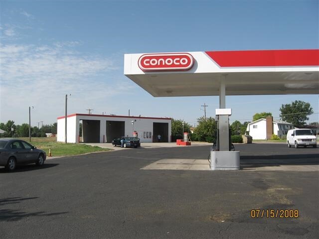
Property Detail
675 Kimball Ave
010278788
BLK 1, GREENWALT SECOND ADD
Carwashselfserve
Scotts Bluff
COMMERCIAL
Nebraska
2025
1.54 AC
2025
Nebraska Area
953800
Other Market Areas
1,638 SF
Scottsbluff, NE
NEARBY LISTINGS FOR SALE OR LEASE
-
-
View all Gering listings for sale on LoopNet.com
DEMOGRAPHICS near 675 Kimball Ave
1 mile
3 mile
5 mile
2025 Total Population
5,270
10,403
25,193
2030 Population
5,211
10,342
25,146
Pop Growth 2025-2030
(1.12%)
(0.59%)
(0.19%)
Average Age
40
41
40
2025 Total Households
2,105
4,085
10,168
HH Growth 2025-2030
(1.24%)
(0.73%)
(0.22%)
Median Household Inc
$60,370
$69,800
$60,590
Avg Household Size
2.40
2.40
2.40
2025 Avg HH Vehicles
2.00
2.00
2.00
Median Home Value
$181,850
$179,889
$170,371
Median Year Built
1972
1971
1967
Nearby Places
Map Layers
Map Styles
 Street
 Aerial
Layers
 Traffic
 Biking
Places
Listings with unknown addresses are not visible on the map
- Restaurants
- Banks
- Shops
- Fitness
- Groceries
SALE & LEASE HISTORY
LISTING DATE
SALE/LEASE

Jun 15, 2017
For Sale
Aug 01, 2017
For Sale
Nearby Properties
Address
Land Use
TOTAL SIZE
Lot Size
Zoning
Address
Land Use
TOTAL SIZE
Lot Size
Zoning
32,376 SF
0.96 AC
COMMERCIAL
Address
Land Use
TOTAL SIZE
Lot Size
Zoning
2,790 SF
8.51 AC
COMMERCIAL
Address
Land Use
TOTAL SIZE
Lot Size
Zoning
3,016 SF
18.03 AC
COMMERCIAL
Address
Land Use
TOTAL SIZE
Lot Size
Zoning
80,000 SF
24.45 AC
COMMERCIAL
Address
Land Use
TOTAL SIZE
Lot Size
Zoning
30,256 SF
32.50 AC
INDUSTRIAL
Address
Land Use
TOTAL SIZE
Lot Size
Zoning
52,508 SF
COMMERCIAL
Address
Land Use
TOTAL SIZE
Lot Size
Zoning
48.46 AC
COMMERCIAL
Address
Land Use
TOTAL SIZE
Lot Size
Zoning
23,440 SF
3.44 AC
COMMERCIAL
Address
Land Use
TOTAL SIZE
Lot Size
Zoning
1,440 SF
COMMERCIAL
Address
Land Use
TOTAL SIZE
Lot Size
Zoning
3,860 SF
1.13 AC
COMMERCIAL
Address
Land Use
TOTAL SIZE
Lot Size
Zoning
1,484 SF
9.17 AC
INDUSTRIAL
Address
Land Use
TOTAL SIZE
Lot Size
Zoning
6,258 SF
0.83 AC
00
Address
Land Use
TOTAL SIZE
Lot Size
Zoning
11,267 SF
1.47 AC
COMMERCIAL
Address
Land Use
TOTAL SIZE
Lot Size
Zoning
11,626 SF
11.36 AC
COMMERCIAL
Address
Land Use
TOTAL SIZE
Lot Size
Zoning
34,325 SF
2.09 AC
COMMERCIAL
Address
Land Use
TOTAL SIZE
Lot Size
Zoning
864 SF
3.40 AC
COMMERCIAL
Address
Land Use
TOTAL SIZE
Lot Size
Zoning
525 SF
8.78 AC
INDUSTRIAL
Address
Land Use
TOTAL SIZE
Lot Size
Zoning
38,596 SF
3.46 AC
COMMERCIAL
Address
Land Use
TOTAL SIZE
Lot Size
Zoning
2,240 SF
2.15 AC
COMMERCIAL
Address
Land Use
TOTAL SIZE
Lot Size
Zoning
5,400 SF
5.28 AC
COMMERCIAL
Address
Land Use
TOTAL SIZE
Lot Size
Zoning
9,472 SF
0.91 AC
COMMERCIAL
Address
Land Use
TOTAL SIZE
Lot Size
Zoning
450 SF
4.16 AC
COMMERCIAL
Address
Land Use
TOTAL SIZE
Lot Size
Zoning
1,052 SF
3.46 AC
COMMERCIAL
Address
Land Use
TOTAL SIZE
Lot Size
Zoning
2,300 SF
3.95 AC
COMMERCIAL
Address
Land Use
TOTAL SIZE
Lot Size
Zoning
4,800 SF
35.57 AC
COMMERCIAL
Address
Land Use
TOTAL SIZE
Lot Size
Zoning
3,000 SF
3 AC
COMMERCIAL
Address
Land Use
TOTAL SIZE
Lot Size
Zoning
30,455 SF
6.56 AC
INDUSTRIAL
Address
Land Use
TOTAL SIZE
Lot Size
Zoning
19,876 SF
4.64 AC
00
Address
Land Use
TOTAL SIZE
Lot Size
Zoning
72,500 SF
8 AC
INDUSTRIAL
Address
Land Use
TOTAL SIZE
Lot Size
Zoning
4,033 SF
0.34 AC
COMMERCIAL
The World's #1 Commercial Real Estate Marketplace
Connect with us
© 2026 CoStar Group
The information above has been obtained from sources believed reliable. While we do not doubt its accuracy we have not verified it and make no guarantee, warranty or representation about it. It is your responsibility to independently confirm its accuracy and completeness. Any projections, opinions, assumptions, or estimates used are for example only and do not represent the current or future performance of the property. The value of this transaction to you depends on tax and other factors which should be evaluated by your tax, financial, and legal advisors. You and your advisors should conduct a careful, independent investigation of the property to determine to your satisfaction the suitability of the property for your needs.