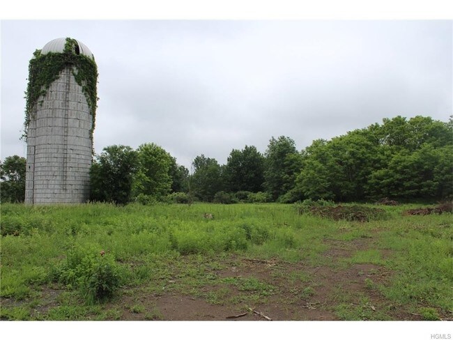
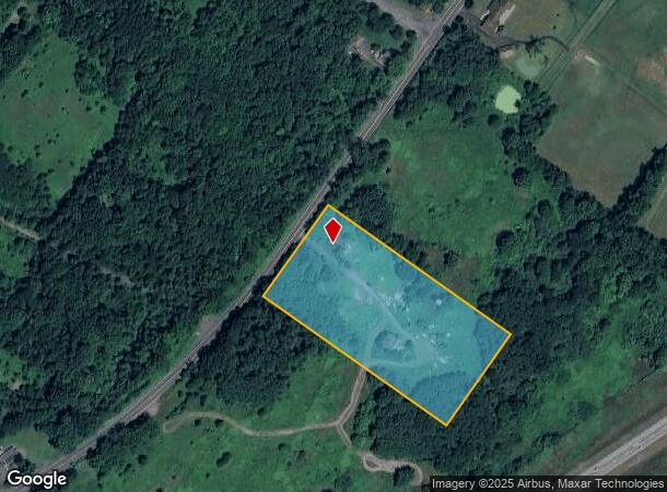
Property Record
675 State Route 211, Montgomery, NY 12549

NEARBY LISTINGS FOR SALE OR LEASE
Property Detail
675 State Route 211
334289-035-000-0001-019.100-0000
ES ST HWY 211 SEE JUDGMENT #7454-99 FOR RETURN OF PARCEL
Multifamilydwelling
Orange
X
New York
36071C0282E
19.10
2024
4.10 AC
2024
Middletown
010801
Northern New Jersey
4,194 SF
New York-Jersey City-White Plains, NY-NJ
DEMOGRAPHICS near 675 State Route 211
1 Mile
3 Mile
5 Mile
2024 Total Population
94
8,763
22,967
2029 Population
97
8,887
23,307
Pop Growth 2024-2029
+ 3.19%
+ 1.42%
+ 1.48%
Average Age
41
41
41
2024 Total Households
31
3,235
8,184
HH Growth 2024-2029
+ 3.23%
+ 1.45%
+ 1.54%
Median Household Inc
$115,624
$100,383
$100,287
Avg Household Size
2.90
2.70
2.70
2024 Avg HH Vehicles
2.00
2.00
2.00
Median Home Value
$430,000
$314,591
$338,603
Median Year Built
1969
1978
1978
Nearby Places
- Restaurants
- Banks
- Shops
- Fitness
- Groceries
PUBLIC TRANSPORTATION
COMMUTER RAIL
Campbell Hall (Bergen County/Port Jervis Line - NJ Transit Commuter Rail (NJ Transit), Main/Port Jervis Line - NJ Transit Commuter Rail (NJ Transit))
DRIVE
WALK
Distance
Campbell Hall (Bergen County/Port Jervis Line - NJ Transit Commuter Rail (NJ Transit), Main/Port Jervis Line - NJ Transit Commuter Rail (NJ Transit))
11 min
6.2 mi
Middletown New York (Bergen County/Port Jervis Line - NJ Transit Commuter Rail (NJ Transit), Main/Port Jervis Line - NJ Transit Commuter Rail (NJ Transit))
DRIVE
WALK
Distance
Middletown New York (Bergen County/Port Jervis Line - NJ Transit Commuter Rail (NJ Transit), Main/Port Jervis Line - NJ Transit Commuter Rail (NJ Transit))
13 min
6.8 mi
AIRPORT
New York Stewart International
DRIVE
WALK
Distance
New York Stewart International
21 min
12.3 mi
Freight Ports
Port Newark Container Terminal
DRIVE
WALK
Distance
Port Newark Container Terminal
100 min
75.8 mi
SALE & LEASE HISTORY
LISTING DATE
SALE/LEASE

Nov 18, 2016
For Sale
Aug 28, 2017
For Sale
Aug 18, 2017
For Sale
Nearby Properties
Address
Land Use
TOTAL SIZE
Lot Size
Zoning
Address
Land Use
TOTAL SIZE
Lot Size
Zoning
1,332,075 SF
118 AC
I1
Address
Land Use
TOTAL SIZE
Lot Size
Zoning
1,040,580 SF
70.80 AC
ID
Address
Land Use
TOTAL SIZE
Lot Size
Zoning
513,951 SF
112.80 AC
ID
Address
Land Use
TOTAL SIZE
Lot Size
Zoning
249,128 SF
43.72 AC
ID
Address
Land Use
TOTAL SIZE
Lot Size
Zoning
340,782 SF
37 AC
LUI
Address
Land Use
TOTAL SIZE
Lot Size
Zoning
374,356 SF
35.90 AC
LUI
Address
Land Use
TOTAL SIZE
Lot Size
Zoning
760,927 SF
51.60 AC
ID
Address
Land Use
TOTAL SIZE
Lot Size
Zoning
25,800 SF
80.20 AC
LUI
Address
Land Use
TOTAL SIZE
Lot Size
Zoning
312,980 SF
42.30 AC
ID
Address
Land Use
TOTAL SIZE
Lot Size
Zoning
366,680 SF
32.10 AC
Address
Land Use
TOTAL SIZE
Lot Size
Zoning
121,460 SF
42.70 AC
ID
Address
Land Use
TOTAL SIZE
Lot Size
Zoning
Address
Land Use
TOTAL SIZE
Lot Size
Zoning
109,481 SF
24.90 AC
ID
Address
Land Use
TOTAL SIZE
Lot Size
Zoning
330.10 AC
R4A*
Address
Land Use
TOTAL SIZE
Lot Size
Zoning
103,079 SF
30.60 AC
ID
Address
Land Use
TOTAL SIZE
Lot Size
Zoning
4,022 SF
360.50 AC
R4A*
Address
Land Use
TOTAL SIZE
Lot Size
Zoning
41.40 AC
R4A
Address
Land Use
TOTAL SIZE
Lot Size
Zoning
55,200 SF
11.80 AC
R3A*
Address
Land Use
TOTAL SIZE
Lot Size
Zoning
Address
Land Use
TOTAL SIZE
Lot Size
Zoning
10,433 SF
334.40 AC
I1
Address
Land Use
TOTAL SIZE
Lot Size
Zoning
10 AC
HRC4*
Address
Land Use
TOTAL SIZE
Lot Size
Zoning
63,139 SF
5.40 AC
Address
Land Use
TOTAL SIZE
Lot Size
Zoning
62,557 SF
37.20 AC
ID
Address
Land Use
TOTAL SIZE
Lot Size
Zoning
1,240 SF
188 AC
R4A*
Address
Land Use
TOTAL SIZE
Lot Size
Zoning
Address
Land Use
TOTAL SIZE
Lot Size
Zoning
22,062 SF
16.40 AC
ID
Address
Land Use
TOTAL SIZE
Lot Size
Zoning
83,114 SF
5.30 AC
R-SC
Address
Land Use
TOTAL SIZE
Lot Size
Zoning
731,864 SF
43.70 AC
I
Address
Land Use
TOTAL SIZE
Lot Size
Zoning
18,270 SF
5.50 AC
RM1
Address
Land Use
TOTAL SIZE
Lot Size
Zoning
7,948 SF
115 AC
R4A
The World's #1 Commercial Real Estate Marketplace
Connect with us
© 2025 CoStar Group
The information above has been obtained from sources believed reliable. While we do not doubt its accuracy we have not verified it and make no guarantee, warranty or representation about it. It is your responsibility to independently confirm its accuracy and completeness. Any projections, opinions, assumptions, or estimates used are for example only and do not represent the current or future performance of the property. The value of this transaction to you depends on tax and other factors which should be evaluated by your tax, financial, and legal advisors. You and your advisors should conduct a careful, independent investigation of the property to determine to your satisfaction the suitability of the property for your needs.