Property Record
675 State Route 3, Plattsburgh, NY 12901
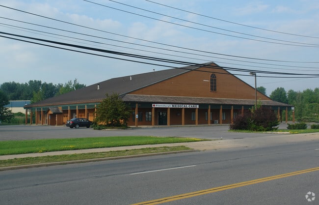

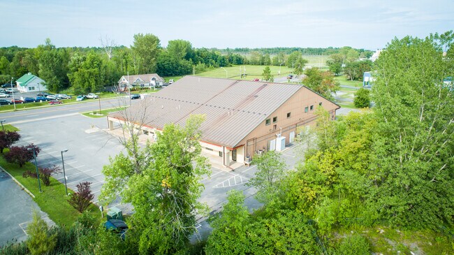
This Property Is For Sale
Property Detail
675 State Route 3
094200-220-000-0001-009-000-0000
LOT 37 PAT POP WYAND ASSOCIATES
Professionalbldglegalinsurancerealestateetc
Clinton
T4
New York
B and X Area of moderate flood hazard, usually the area between the limits of the 100-year and 500-year floods.
9.000
2025
1.80 AC
2025
Adirondack Mountains Area
101600
Other Market Areas
27,600 SF
Plattsburgh, NY
NEARBY LISTINGS FOR SALE OR LEASE
DEMOGRAPHICS near 675 State Route 3
1 mile
3 mile
5 mile
2025 Total Population
916
19,580
31,532
2030 Population
923
19,316
31,065
Pop Growth 2025-2030
+ 0.76%
(1.35%)
(1.48%)
Average Age
44
41
42
2025 Total Households
385
8,799
14,381
HH Growth 2025-2030
+ 0.78%
(1.40%)
(1.51%)
Median Household Inc
$73,420
$53,915
$55,829
Avg Household Size
2.30
2.10
2.10
2025 Avg HH Vehicles
2.00
2.00
2.00
Median Home Value
$212,987
$189,813
$189,459
Median Year Built
1995
1971
1973
Nearby Places
Map Layers
Map Styles
 Street
 Aerial
Layers
 Traffic
 Biking
Places
Listings with unknown addresses are not visible on the map
- Restaurants
- Banks
- Shops
- Fitness
- Groceries
PUBLIC TRANSPORTATION
COMMUTER RAIL
Plattsburgh Amtrak Station (Adirondack - Amtrak)
Drive
Walk
Distance
Plattsburgh Amtrak Station (Adirondack - Amtrak)
6 min
3.6 mi
AIRPORT
Plattsburgh International
Drive
Walk
Distance
Plattsburgh International
10 min
5.9 mi
Patrick Leahy Burlington International
Drive
Walk
Distance
Patrick Leahy Burlington International
71 min
33.7 mi
Freight Ports
Montreal
Drive
Walk
Distance
Montreal
89 min
67.3 mi
Nearby Properties
Address
Land Use
TOTAL SIZE
Lot Size
Zoning
Address
Land Use
TOTAL SIZE
Lot Size
Zoning
103.84 AC
Address
Land Use
TOTAL SIZE
Lot Size
Zoning
404,903 SF
40.60 AC
03 - MULTI
Address
Land Use
TOTAL SIZE
Lot Size
Zoning
131,558 SF
53.50 AC
T5
Address
Land Use
TOTAL SIZE
Lot Size
Zoning
15.80 AC
Address
Land Use
TOTAL SIZE
Lot Size
Zoning
112,400 SF
13.20 AC
I
Address
Land Use
TOTAL SIZE
Lot Size
Zoning
99,232 SF
21.27 AC
SD
Address
Land Use
TOTAL SIZE
Lot Size
Zoning
87,442 SF
5.32 AC
02 - SINGL
Address
Land Use
TOTAL SIZE
Lot Size
Zoning
35,562 SF
204.40 AC
LC_OS
Address
Land Use
TOTAL SIZE
Lot Size
Zoning
128,028 SF
38.20 AC
T4
Address
Land Use
TOTAL SIZE
Lot Size
Zoning
83,261 SF
24.35 AC
T5
Address
Land Use
TOTAL SIZE
Lot Size
Zoning
73,095 SF
6.28 AC
T4
Address
Land Use
TOTAL SIZE
Lot Size
Zoning
167 AC
02 - SINGL
Address
Land Use
TOTAL SIZE
Lot Size
Zoning
101,758 SF
5.64 AC
T5
Address
Land Use
TOTAL SIZE
Lot Size
Zoning
117,847 SF
47.30 AC
00
Address
Land Use
TOTAL SIZE
Lot Size
Zoning
148,340 SF
5.67 AC
03 - MULTI
Address
Land Use
TOTAL SIZE
Lot Size
Zoning
243,951 SF
21 AC
06 - INDUS
Address
Land Use
TOTAL SIZE
Lot Size
Zoning
218,230 SF
38.92 AC
I
Address
Land Use
TOTAL SIZE
Lot Size
Zoning
578,793 SF
75.50 AC
T5
Address
Land Use
TOTAL SIZE
Lot Size
Zoning
87,939 SF
8.20 AC
T5
Address
Land Use
TOTAL SIZE
Lot Size
Zoning
2.96 AC
R-2
Address
Land Use
TOTAL SIZE
Lot Size
Zoning
64,343 SF
2.30 AC
C
Address
Land Use
TOTAL SIZE
Lot Size
Zoning
21,396 SF
3.40 AC
03 - MULTI
Address
Land Use
TOTAL SIZE
Lot Size
Zoning
4,992 SF
13.20 AC
03 - MULTI
Address
Land Use
TOTAL SIZE
Lot Size
Zoning
145,190 SF
26.57 AC
IP
Address
Land Use
TOTAL SIZE
Lot Size
Zoning
11,910 SF
3.70 AC
05 - COMME
Address
Land Use
TOTAL SIZE
Lot Size
Zoning
62,148 SF
2.66 AC
T4
Address
Land Use
TOTAL SIZE
Lot Size
Zoning
126,842 SF
10 AC
T5
Address
Land Use
TOTAL SIZE
Lot Size
Zoning
84,193 SF
10.60 AC
03 - MULTI
Address
Land Use
TOTAL SIZE
Lot Size
Zoning
59,670 SF
0.50 AC
03 - MULTI
Address
Land Use
TOTAL SIZE
Lot Size
Zoning
210,800 SF
2.42 AC
I
The World's #1 Commercial Real Estate Marketplace
Connect with us
© 2026 CoStar Group
The information above has been obtained from sources believed reliable. While we do not doubt its accuracy we have not verified it and make no guarantee, warranty or representation about it. It is your responsibility to independently confirm its accuracy and completeness. Any projections, opinions, assumptions, or estimates used are for example only and do not represent the current or future performance of the property. The value of this transaction to you depends on tax and other factors which should be evaluated by your tax, financial, and legal advisors. You and your advisors should conduct a careful, independent investigation of the property to determine to your satisfaction the suitability of the property for your needs.