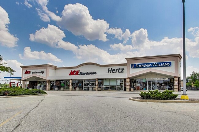
Property Record
719 W Golf Rd, Hoffman Estates, IL 60169

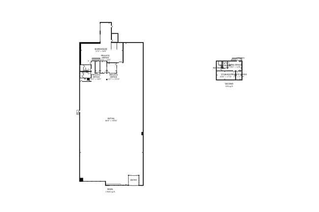

Current Lease Availabilities
Property Detail
719 W Golf Rd
Chicago-Naperville-Elgin, IL-IN
(MOBILS) SUB OF PT OF NE SEC 16-41-10
07-16-200-030-0000
Cook
Commercialbuilding
Illinois
B and X Area of moderate flood hazard, usually the area between the limits of the 100-year and 500-year floods.
1
2023
2.48 AC
2025
Schaumburg Area
804715
Chicago
28,969 SF
NEARBY LISTINGS FOR SALE OR LEASE
DEMOGRAPHICS near 719 W Golf Rd
1 mile
3 mile
5 mile
2025 Total Population
19,248
105,261
252,970
2030 Population
19,377
106,067
254,597
Pop Growth 2025-2030
+ 0.67%
+ 0.77%
+ 0.64%
Average Age
39
41
41
2025 Total Households
7,006
39,126
92,693
HH Growth 2025-2030
+ 0.56%
+ 0.58%
+ 0.48%
Median Household Inc
$92,251
$99,041
$102,751
Avg Household Size
2.60
2.60
2.60
2025 Avg HH Vehicles
2.00
2.00
2.00
Median Home Value
$320,253
$331,525
$327,415
Median Year Built
1974
1976
1976
Nearby Places
Map Layers
Map Styles
 Street
 Aerial
Transit
 Traffic
 Biking
Places
Listings with unknown addresses are not visible on the map
- Restaurants
- Banks
- Shops
- Fitness
- Groceries
PUBLIC TRANSPORTATION
COMMUTER RAIL
Roselle Station (Milwaukee District West Line - Northeast Illinois Regional Commuter Railroad (Metra))
Drive
Walk
Distance
Roselle Station (Milwaukee District West Line - Northeast Illinois Regional Commuter Railroad (Metra))
13 min
6.1 mi
Schaumburg Station (Milwaukee District West Line - Northeast Illinois Regional Commuter Railroad (Metra))
Drive
Walk
Distance
Schaumburg Station (Milwaukee District West Line - Northeast Illinois Regional Commuter Railroad (Metra))
14 min
7.0 mi
AIRPORT
Chicago O'Hare International
Drive
Walk
Distance
Chicago O'Hare International
23 min
16.7 mi
Chicago Midway International
Drive
Walk
Distance
Chicago Midway International
45 min
30.7 mi
Freight Ports
Port Milwaukee
Drive
Walk
Distance
Port Milwaukee
102 min
82.6 mi
Nearby Properties
Address
Land Use
TOTAL SIZE
Lot Size
Zoning
Address
Land Use
TOTAL SIZE
Lot Size
Zoning
42.14 AC
Address
Land Use
TOTAL SIZE
Lot Size
Zoning
800,552 SF
38.86 AC
Address
Land Use
TOTAL SIZE
Lot Size
Zoning
3,464 SF
60.04 AC
Address
Land Use
TOTAL SIZE
Lot Size
Zoning
Address
Land Use
TOTAL SIZE
Lot Size
Zoning
Address
Land Use
TOTAL SIZE
Lot Size
Zoning
300,000 SF
9.29 AC
Address
Land Use
TOTAL SIZE
Lot Size
Zoning
875,776 SF
8.73 AC
Address
Land Use
TOTAL SIZE
Lot Size
Zoning
934,038 SF
45.88 AC
Address
Land Use
TOTAL SIZE
Lot Size
Zoning
Address
Land Use
TOTAL SIZE
Lot Size
Zoning
Address
Land Use
TOTAL SIZE
Lot Size
Zoning
Address
Land Use
TOTAL SIZE
Lot Size
Zoning
490,458 SF
13.52 AC
Address
Land Use
TOTAL SIZE
Lot Size
Zoning
305,008 SF
40.11 AC
Address
Land Use
TOTAL SIZE
Lot Size
Zoning
32,500 SF
2.92 AC
Address
Land Use
TOTAL SIZE
Lot Size
Zoning
302,135 SF
19.28 AC
Address
Land Use
TOTAL SIZE
Lot Size
Zoning
Address
Land Use
TOTAL SIZE
Lot Size
Zoning
300,686 SF
8.47 AC
Address
Land Use
TOTAL SIZE
Lot Size
Zoning
382,200 SF
45.71 AC
Address
Land Use
TOTAL SIZE
Lot Size
Zoning
28,913 SF
6.63 AC
Address
Land Use
TOTAL SIZE
Lot Size
Zoning
388,080 SF
12.64 AC
Address
Land Use
TOTAL SIZE
Lot Size
Zoning
527,661 SF
27.39 AC
Address
Land Use
TOTAL SIZE
Lot Size
Zoning
175,200 SF
89.08 AC
Address
Land Use
TOTAL SIZE
Lot Size
Zoning
369,303 SF
29.96 AC
Address
Land Use
TOTAL SIZE
Lot Size
Zoning
375,417 SF
13.35 AC
Address
Land Use
TOTAL SIZE
Lot Size
Zoning
245,525 SF
14.69 AC
Address
Land Use
TOTAL SIZE
Lot Size
Zoning
161,514 SF
11.17 AC
Address
Land Use
TOTAL SIZE
Lot Size
Zoning
392,258 SF
12.51 AC
Address
Land Use
TOTAL SIZE
Lot Size
Zoning
19.35 AC
Address
Land Use
TOTAL SIZE
Lot Size
Zoning
66,774 SF
3.46 AC
Address
Land Use
TOTAL SIZE
Lot Size
Zoning
223,043 SF
10.21 AC
The World's #1 Commercial Real Estate Marketplace
Connect with us
© 2026 CoStar Group
The information above has been obtained from sources believed reliable. While we do not doubt its accuracy we have not verified it and make no guarantee, warranty or representation about it. It is your responsibility to independently confirm its accuracy and completeness. Any projections, opinions, assumptions, or estimates used are for example only and do not represent the current or future performance of the property. The value of this transaction to you depends on tax and other factors which should be evaluated by your tax, financial, and legal advisors. You and your advisors should conduct a careful, independent investigation of the property to determine to your satisfaction the suitability of the property for your needs.