Property Record
6750 Mchard Rd, Houston, TX 77053
NEARBY LISTINGS FOR SALE OR LEASE
Property Detail
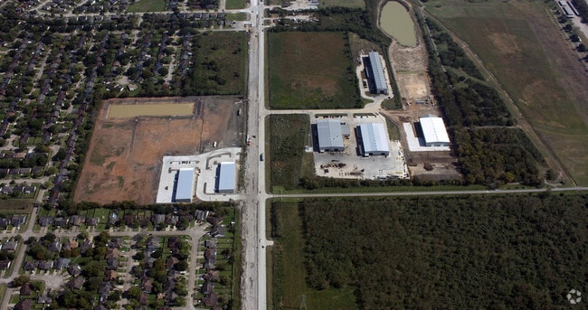
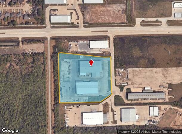
6750 Mchard Rd
Houston-Pasadena-The Woodlands, TX
Thos W Thompson
0335-00-000-2316-907
0335 THOS W THOMPSON, ACRES 7.215, UNRESTRICTED RESERVE A, BLOCK 1, ENERGY PARK SOUTH PARTIAL REPLAT NO 1
Commercialnec
Fort Bend
AE
Texas
48157C0305M
7.22 AC
2024
Southwest Far
2025
Houston
670700
DEMOGRAPHICS near 6750 Mchard Rd
1 Mile
3 Mile
5 Mile
2024 Total Population
8,872
75,380
244,878
2029 Population
10,573
86,165
275,771
Pop Growth 2024-2029
+ 19.17%
+ 14.31%
+ 12.62%
Average Age
37
36
37
2024 Total Households
2,719
23,323
78,751
HH Growth 2024-2029
+ 19.79%
+ 14.98%
+ 13.06%
Median Household Inc
$58,644
$67,433
$71,945
Avg Household Size
3.20
3.20
3.00
2024 Avg HH Vehicles
2.00
2.00
2.00
Median Home Value
$114,152
$176,099
$197,453
Median Year Built
1979
1992
1998
Nearby Places
Map Layers
Map Styles
 Street
 Aerial
- Restaurants
- Banks
- Shops
- Fitness
- Groceries
PUBLIC TRANSPORTATION
AIRPORT
William P Hobby
DRIVE
WALK
Distance
William P Hobby
28 min
16.2 mi
George Bush Intcntl/Houston
DRIVE
WALK
Distance
George Bush Intcntl/Houston
49 min
35.0 mi
Freight Ports
Port of Houston
DRIVE
WALK
Distance
Port of Houston
34 min
20.4 mi
Nearby Properties
Address
Land Use
TOTAL SIZE
Lot Size
Zoning
Address
Land Use
TOTAL SIZE
Lot Size
Zoning
1,139,160 SF
75.11 AC
Address
Land Use
TOTAL SIZE
Lot Size
Zoning
542,333 SF
43.95 AC
Address
Land Use
TOTAL SIZE
Lot Size
Zoning
429,368 SF
27.94 AC
Address
Land Use
TOTAL SIZE
Lot Size
Zoning
460,711 SF
18.98 AC
Address
Land Use
TOTAL SIZE
Lot Size
Zoning
423,270 SF
32.95 AC
Address
Land Use
TOTAL SIZE
Lot Size
Zoning
281,889 SF
10.84 AC
Address
Land Use
TOTAL SIZE
Lot Size
Zoning
240,000 SF
12.45 AC
Address
Land Use
TOTAL SIZE
Lot Size
Zoning
306,103 SF
64.07 AC
QY
Address
Land Use
TOTAL SIZE
Lot Size
Zoning
19.33 AC
Address
Land Use
TOTAL SIZE
Lot Size
Zoning
209,728 SF
11.93 AC
Address
Land Use
TOTAL SIZE
Lot Size
Zoning
84,673 SF
9.57 AC
X
Address
Land Use
TOTAL SIZE
Lot Size
Zoning
3,108 SF
57.41 AC
Address
Land Use
TOTAL SIZE
Lot Size
Zoning
179,599 SF
16.45 AC
Address
Land Use
TOTAL SIZE
Lot Size
Zoning
176,000 SF
14.15 AC
Address
Land Use
TOTAL SIZE
Lot Size
Zoning
169,176 SF
24.31 AC
Address
Land Use
TOTAL SIZE
Lot Size
Zoning
880 SF
14.36 AC
Address
Land Use
TOTAL SIZE
Lot Size
Zoning
113,040 SF
8.14 AC
Address
Land Use
TOTAL SIZE
Lot Size
Zoning
77,941 SF
103.54 AC
Address
Land Use
TOTAL SIZE
Lot Size
Zoning
112,500 SF
7 AC
Address
Land Use
TOTAL SIZE
Lot Size
Zoning
85,092 SF
12.95 AC
Address
Land Use
TOTAL SIZE
Lot Size
Zoning
132,075 SF
3.09 AC
Address
Land Use
TOTAL SIZE
Lot Size
Zoning
132,938 SF
29 AC
MZY
Address
Land Use
TOTAL SIZE
Lot Size
Zoning
71,596 SF
10.18 AC
Address
Land Use
TOTAL SIZE
Lot Size
Zoning
110,450 SF
7.58 AC
Address
Land Use
TOTAL SIZE
Lot Size
Zoning
114,705 SF
3.60 AC
Address
Land Use
TOTAL SIZE
Lot Size
Zoning
52,464 SF
9.69 AC
Address
Land Use
TOTAL SIZE
Lot Size
Zoning
75,000 SF
13.70 AC
Address
Land Use
TOTAL SIZE
Lot Size
Zoning
88,802 SF
2.35 AC
Address
Land Use
TOTAL SIZE
Lot Size
Zoning
114,791 SF
4.04 AC
Address
Land Use
TOTAL SIZE
Lot Size
Zoning
117,467 SF
19.39 AC
The World's #1 Commercial Real Estate Marketplace
Connect with us
© 2026 CoStar Group
The information above has been obtained from sources believed reliable. While we do not doubt its accuracy we have not verified it and make no guarantee, warranty or representation about it. It is your responsibility to independently confirm its accuracy and completeness. Any projections, opinions, assumptions, or estimates used are for example only and do not represent the current or future performance of the property. The value of this transaction to you depends on tax and other factors which should be evaluated by your tax, financial, and legal advisors. You and your advisors should conduct a careful, independent investigation of the property to determine to your satisfaction the suitability of the property for your needs.