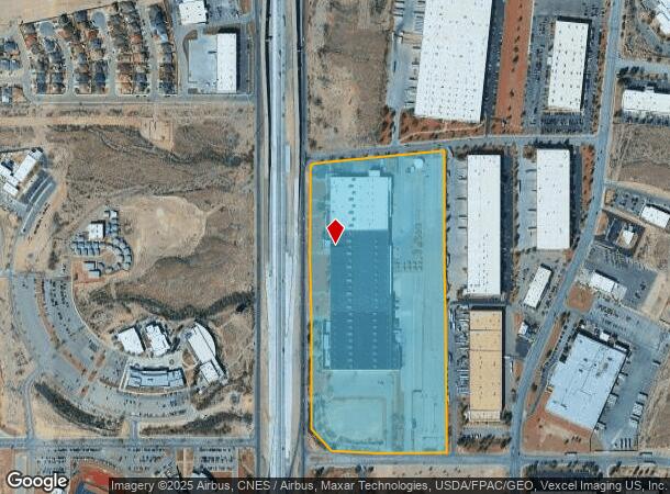
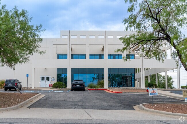
Property Record
6750 N Desert Blvd, El Paso, TX 79912


NEARBY LISTINGS FOR SALE OR LEASE
Property Detail
6750 N Desert Blvd
El Paso, TX
Westport #1
W178-999-0010-0100
1 WESTPORT #1 1 TO 3 (33.4439 AC)
Industrialgeneral
El Paso
2024
Texas
2025
33.44 AC
010226
West
415,500 SF
El Paso
DEMOGRAPHICS near 6750 N Desert Blvd
1 Mile
3 Mile
5 Mile
2024 Total Population
5,120
49,896
116,194
2029 Population
5,264
50,695
118,102
Pop Growth 2024-2029
+ 2.81%
+ 1.60%
+ 1.64%
Average Age
32
36
37
2024 Total Households
1,668
16,483
39,472
HH Growth 2024-2029
+ 2.70%
+ 1.55%
+ 1.61%
Median Household Inc
$76,518
$76,684
$74,226
Avg Household Size
3.00
3.00
2.90
2024 Avg HH Vehicles
2.00
2.00
2.00
Median Home Value
$197,583
$204,343
$222,336
Median Year Built
2010
2001
1994
Nearby Places
Map Layers
Map Styles
 Street
 Aerial
- Restaurants
- Banks
- Shops
- Fitness
- Groceries
PUBLIC TRANSPORTATION
AIRPORT
El Paso International
DRIVE
WALK
Distance
El Paso International
38 min
23.0 mi
Freight Ports
Port of Corpus Christi
DRIVE
WALK
Distance
Port of Corpus Christi
698 min
708.9 mi
SALE & LEASE HISTORY
LISTING DATE
SALE/LEASE

Sep 25, 2016
For Lease
Sep 24, 2016
For Sale
Mar 09, 2021
For Sale
Mar 05, 2025
For Lease
Mar 04, 2024
For Lease
Jun 13, 2018
For Sale
Jan 29, 2018
For Sale
Feb 13, 2025
For Lease
Feb 08, 2018
For Sale
Apr 28, 2022
For Lease
Nearby Properties
Address
Land Use
TOTAL SIZE
Lot Size
Zoning
Address
Land Use
TOTAL SIZE
Lot Size
Zoning
279,966 SF
44.49 AC
C4C
Address
Land Use
TOTAL SIZE
Lot Size
Zoning
409,742 SF
37.76 AC
C4
Address
Land Use
TOTAL SIZE
Lot Size
Zoning
127,552 SF
14.24 AC
C4
Address
Land Use
TOTAL SIZE
Lot Size
Zoning
545,506 SF
50.94 AC
M1
Address
Land Use
TOTAL SIZE
Lot Size
Zoning
236,134 SF
14.49 AC
C1
Address
Land Use
TOTAL SIZE
Lot Size
Zoning
234,339 SF
10.03 AC
C3C
Address
Land Use
TOTAL SIZE
Lot Size
Zoning
149,913 SF
66.49 AC
R3S
Address
Land Use
TOTAL SIZE
Lot Size
Zoning
402,206 SF
21.82 AC
C4C
Address
Land Use
TOTAL SIZE
Lot Size
Zoning
199,384 SF
17.91 AC
C4
Address
Land Use
TOTAL SIZE
Lot Size
Zoning
112,960 SF
Address
Land Use
TOTAL SIZE
Lot Size
Zoning
220,159 SF
29.02 AC
C4
Address
Land Use
TOTAL SIZE
Lot Size
Zoning
79,722 SF
11 AC
C3
Address
Land Use
TOTAL SIZE
Lot Size
Zoning
103,525 SF
7 AC
M1
Address
Land Use
TOTAL SIZE
Lot Size
Zoning
206,600 SF
10.74 AC
AO
Address
Land Use
TOTAL SIZE
Lot Size
Zoning
115,155 SF
4.63 AC
C2C
Address
Land Use
TOTAL SIZE
Lot Size
Zoning
46,534 SF
9.81 AC
C4C
Address
Land Use
TOTAL SIZE
Lot Size
Zoning
127,595 SF
9.64 AC
C4S
Address
Land Use
TOTAL SIZE
Lot Size
Zoning
159,851 SF
7.19 AC
A2S
Address
Land Use
TOTAL SIZE
Lot Size
Zoning
149,514 SF
18.14 AC
M1
Address
Land Use
TOTAL SIZE
Lot Size
Zoning
143,828 SF
15.77 AC
M1
Address
Land Use
TOTAL SIZE
Lot Size
Zoning
136,776 SF
16.26 AC
C4S
Address
Land Use
TOTAL SIZE
Lot Size
Zoning
290,880 SF
9.79 AC
Address
Land Use
TOTAL SIZE
Lot Size
Zoning
21,621 SF
167.69 AC
R3
Address
Land Use
TOTAL SIZE
Lot Size
Zoning
271,352 SF
29.85 AC
M1S
Address
Land Use
TOTAL SIZE
Lot Size
Zoning
119,090 SF
11.66 AC
C4
Address
Land Use
TOTAL SIZE
Lot Size
Zoning
239,984 SF
13.50 AC
M1
Address
Land Use
TOTAL SIZE
Lot Size
Zoning
161,000 SF
10.37 AC
C4
Address
Land Use
TOTAL SIZE
Lot Size
Zoning
44,694 SF
4.86 AC
C3
Address
Land Use
TOTAL SIZE
Lot Size
Zoning
64,722 SF
3.14 AC
C3
The World's #1 Commercial Real Estate Marketplace
Connect with us
© 2025 CoStar Group
The information above has been obtained from sources believed reliable. While we do not doubt its accuracy we have not verified it and make no guarantee, warranty or representation about it. It is your responsibility to independently confirm its accuracy and completeness. Any projections, opinions, assumptions, or estimates used are for example only and do not represent the current or future performance of the property. The value of this transaction to you depends on tax and other factors which should be evaluated by your tax, financial, and legal advisors. You and your advisors should conduct a careful, independent investigation of the property to determine to your satisfaction the suitability of the property for your needs.