Property Record
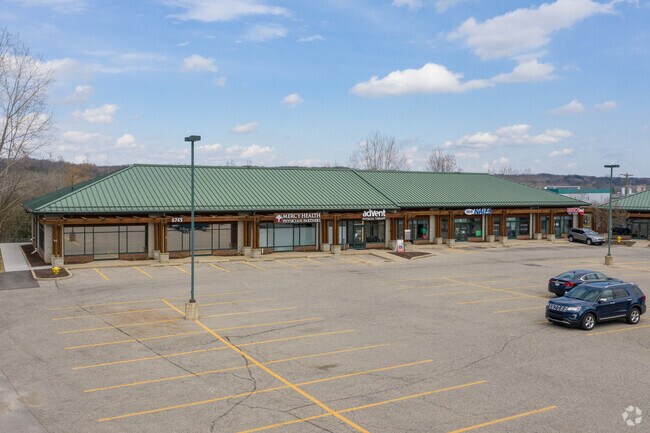
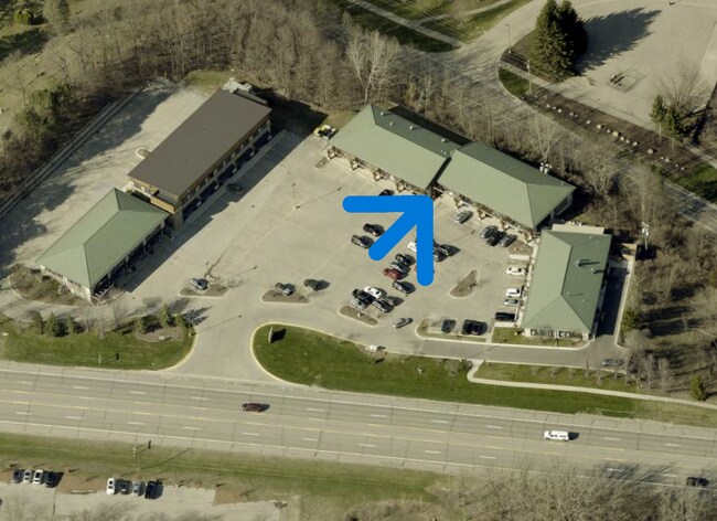
6751 Fulton St E, Ada, MI 49301

Property Detail
6751 Fulton St E
41-15-28-330-005
PART SW 1/4 COM AT S 1/4 COR TH N 0D 19M 57S W ALONG N&S 1/4 LINE 1347.88 FT TH N 74D 44M 42S W 226.43 FT TH N 15D 15M 18S E
Commercialnec
KENT
C2/PUD
Michigan
B and X Area of moderate flood hazard, usually the area between the limits of the 100-year and 500-year floods.
3.50 AC
2025
Ada/Lowell
2025
West Michigan
011901
Grand Rapids-Wyoming-Kentwood, MI
14,522 SF
NEARBY LISTINGS FOR SALE OR LEASE
-
-
View all Ada listings for lease on LoopNet.com
DEMOGRAPHICS near 6751 Fulton St E
1 mile
3 mile
5 mile
2025 Total Population
2,287
20,959
58,357
2030 Population
2,380
21,707
60,067
Pop Growth 2025-2030
+ 4.07%
+ 3.57%
+ 2.93%
Average Age
40
41
40
2025 Total Households
770
7,186
20,963
HH Growth 2025-2030
+ 4.16%
+ 3.67%
+ 3.03%
Median Household Inc
$171,710
$159,993
$122,121
Avg Household Size
3.00
2.90
2.60
2025 Avg HH Vehicles
2.00
2.00
2.00
Median Home Value
$394,076
$508,919
$469,830
Median Year Built
1983
1993
1987
Nearby Places
Map Layers
Map Styles
 Street
 Aerial
Layers
 Traffic
 Biking
Places
Listings with unknown addresses are not visible on the map
- Restaurants
- Banks
- Shops
- Fitness
- Groceries
PUBLIC TRANSPORTATION
AIRPORT
Gerald R Ford International
Drive
Walk
Distance
Gerald R Ford International
19 min
9.4 mi
SALE & LEASE HISTORY
LISTING DATE
SALE/LEASE

Sep 25, 2016
For Lease
Nov 07, 2016
For Lease
May 08, 2017
For Lease
Jun 19, 2025
For Lease
Nearby Properties
Address
Land Use
TOTAL SIZE
Lot Size
Zoning
Address
Land Use
TOTAL SIZE
Lot Size
Zoning
277.36 AC
I
Address
Land Use
TOTAL SIZE
Lot Size
Zoning
709,488 SF
106.95 AC
LI
Address
Land Use
TOTAL SIZE
Lot Size
Zoning
Address
Land Use
TOTAL SIZE
Lot Size
Zoning
226,877 SF
22.40 AC
R2
Address
Land Use
TOTAL SIZE
Lot Size
Zoning
183,583 SF
9.12 AC
R-1
Address
Land Use
TOTAL SIZE
Lot Size
Zoning
8.97 AC
Address
Land Use
TOTAL SIZE
Lot Size
Zoning
Address
Land Use
TOTAL SIZE
Lot Size
Zoning
Address
Land Use
TOTAL SIZE
Lot Size
Zoning
33,540 SF
5.67 AC
PO
Address
Land Use
TOTAL SIZE
Lot Size
Zoning
14,700 SF
1.44 AC
Address
Land Use
TOTAL SIZE
Lot Size
Zoning
0.65 AC
Address
Land Use
TOTAL SIZE
Lot Size
Zoning
67,789 SF
9.51 AC
O-PUD
Address
Land Use
TOTAL SIZE
Lot Size
Zoning
Address
Land Use
TOTAL SIZE
Lot Size
Zoning
64,790 SF
290,921.90 AC
PUD
Address
Land Use
TOTAL SIZE
Lot Size
Zoning
29,224 SF
5.48 AC
I
Address
Land Use
TOTAL SIZE
Lot Size
Zoning
0.20 AC
Address
Land Use
TOTAL SIZE
Lot Size
Zoning
44,215 SF
12.51 AC
PUD
Address
Land Use
TOTAL SIZE
Lot Size
Zoning
4,600 SF
0.64 AC
Address
Land Use
TOTAL SIZE
Lot Size
Zoning
39,312 SF
7.01 AC
R2
Address
Land Use
TOTAL SIZE
Lot Size
Zoning
0.92 AC
C1
Address
Land Use
TOTAL SIZE
Lot Size
Zoning
18,096 SF
2.53 AC
PO
Address
Land Use
TOTAL SIZE
Lot Size
Zoning
87,210 SF
4 AC
I
Address
Land Use
TOTAL SIZE
Lot Size
Zoning
55,541 SF
3.99 AC
C
Address
Land Use
TOTAL SIZE
Lot Size
Zoning
34,276 SF
6.40 AC
PO
Address
Land Use
TOTAL SIZE
Lot Size
Zoning
16,462 SF
1.73 AC
O-PUD
Address
Land Use
TOTAL SIZE
Lot Size
Zoning
9,414 SF
1.64 AC
Address
Land Use
TOTAL SIZE
Lot Size
Zoning
22,848 SF
0.28 AC
Address
Land Use
TOTAL SIZE
Lot Size
Zoning
14,026 SF
2.57 AC
R3
Address
Land Use
TOTAL SIZE
Lot Size
Zoning
19,610 SF
R1
Address
Land Use
TOTAL SIZE
Lot Size
Zoning
0.44 AC
The World's #1 Commercial Real Estate Marketplace
Connect with us
© 2026 CoStar Group
The information above has been obtained from sources believed reliable. While we do not doubt its accuracy we have not verified it and make no guarantee, warranty or representation about it. It is your responsibility to independently confirm its accuracy and completeness. Any projections, opinions, assumptions, or estimates used are for example only and do not represent the current or future performance of the property. The value of this transaction to you depends on tax and other factors which should be evaluated by your tax, financial, and legal advisors. You and your advisors should conduct a careful, independent investigation of the property to determine to your satisfaction the suitability of the property for your needs.