Property Record
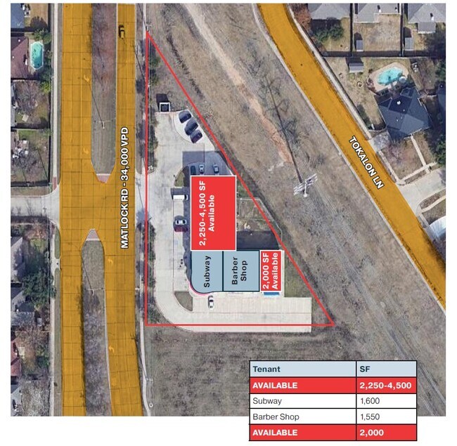
6751 Matlock Rd, Arlington, TX 76002


Property Detail
6751 Matlock Rd
Dallas-Fort Worth-Arlington, TX
MATEDEN LOT 1
41248775
Tarrant
Commercialnec
Texas
B and X Area of moderate flood hazard, usually the area between the limits of the 100-year and 500-year floods.
1
2024
1.03 AC
2025
SE Outlying Tarrant
111542
Dallas/Ft Worth
9,623 SF
NEARBY LISTINGS FOR SALE OR LEASE
DEMOGRAPHICS near 6751 Matlock Rd
1 mile
3 mile
5 mile
2025 Total Population
21,523
125,712
289,555
2030 Population
22,483
131,334
303,700
Pop Growth 2025-2030
+ 4.46%
+ 4.47%
+ 4.89%
Average Age
36
37
37
2025 Total Households
6,490
40,050
96,711
HH Growth 2025-2030
+ 4.61%
+ 4.63%
+ 5.07%
Median Household Inc
$86,528
$100,719
$94,357
Avg Household Size
3.20
3.10
2.90
2025 Avg HH Vehicles
2.00
2.00
2.00
Median Home Value
$297,641
$338,752
$341,196
Median Year Built
1994
1997
1995
Nearby Places
Map Layers
Map Styles
 Street
 Aerial
Transit
 Traffic
 Biking
Places
Listings with unknown addresses are not visible on the map
- Restaurants
- Banks
- Shops
- Fitness
- Groceries
PUBLIC TRANSPORTATION
AIRPORT
Dallas-Fort Worth International
Drive
Walk
Distance
Dallas-Fort Worth International
35 min
23.1 mi
Dallas Love Field
Drive
Walk
Distance
Dallas Love Field
44 min
31.8 mi
SALE & LEASE HISTORY
LISTING DATE
SALE/LEASE

Sep 26, 2016
For Lease
May 03, 2018
For Sale
Jan 16, 2019
For Lease
Dec 13, 2024
For Lease
Nearby Properties
Address
Land Use
TOTAL SIZE
Lot Size
Zoning
Address
Land Use
TOTAL SIZE
Lot Size
Zoning
399,570 SF
75.21 AC
Address
Land Use
TOTAL SIZE
Lot Size
Zoning
453,257 SF
121.21 AC
Address
Land Use
TOTAL SIZE
Lot Size
Zoning
352,649 SF
17.16 AC
Address
Land Use
TOTAL SIZE
Lot Size
Zoning
260,008 SF
139.37 AC
Address
Land Use
TOTAL SIZE
Lot Size
Zoning
419,875 SF
108.14 AC
Address
Land Use
TOTAL SIZE
Lot Size
Zoning
270,214 SF
17.85 AC
Address
Land Use
TOTAL SIZE
Lot Size
Zoning
246,204 SF
15.16 AC
Address
Land Use
TOTAL SIZE
Lot Size
Zoning
258,908 SF
22.41 AC
Address
Land Use
TOTAL SIZE
Lot Size
Zoning
255,134 SF
21.62 AC
Address
Land Use
TOTAL SIZE
Lot Size
Zoning
252,416 SF
15.86 AC
Address
Land Use
TOTAL SIZE
Lot Size
Zoning
858,995 SF
41.93 AC
Address
Land Use
TOTAL SIZE
Lot Size
Zoning
209,307 SF
15.34 AC
Address
Land Use
TOTAL SIZE
Lot Size
Zoning
202,262 SF
12.59 AC
Address
Land Use
TOTAL SIZE
Lot Size
Zoning
77,038 SF
11.46 AC
Address
Land Use
TOTAL SIZE
Lot Size
Zoning
171,820 SF
59.63 AC
Address
Land Use
TOTAL SIZE
Lot Size
Zoning
258,465 SF
8.99 AC
Address
Land Use
TOTAL SIZE
Lot Size
Zoning
425,000 SF
21.26 AC
Address
Land Use
TOTAL SIZE
Lot Size
Zoning
415,800 SF
20.97 AC
Address
Land Use
TOTAL SIZE
Lot Size
Zoning
425,000 SF
21.82 AC
Address
Land Use
TOTAL SIZE
Lot Size
Zoning
226,623 SF
22.90 AC
Address
Land Use
TOTAL SIZE
Lot Size
Zoning
278,273 SF
9.09 AC
Address
Land Use
TOTAL SIZE
Lot Size
Zoning
177,384 SF
28.68 AC
Address
Land Use
TOTAL SIZE
Lot Size
Zoning
182,763 SF
10.54 AC
Address
Land Use
TOTAL SIZE
Lot Size
Zoning
208,010 SF
10 AC
Address
Land Use
TOTAL SIZE
Lot Size
Zoning
165,842 SF
9.48 AC
Address
Land Use
TOTAL SIZE
Lot Size
Zoning
399,496 SF
23.29 AC
Address
Land Use
TOTAL SIZE
Lot Size
Zoning
157,094 SF
9.09 AC
Address
Land Use
TOTAL SIZE
Lot Size
Zoning
276,267 SF
16.10 AC
Address
Land Use
TOTAL SIZE
Lot Size
Zoning
427,622 SF
24.26 AC
Address
Land Use
TOTAL SIZE
Lot Size
Zoning
365,000 SF
9.81 AC
The World's #1 Commercial Real Estate Marketplace
Connect with us
© 2026 CoStar Group
The information above has been obtained from sources believed reliable. While we do not doubt its accuracy we have not verified it and make no guarantee, warranty or representation about it. It is your responsibility to independently confirm its accuracy and completeness. Any projections, opinions, assumptions, or estimates used are for example only and do not represent the current or future performance of the property. The value of this transaction to you depends on tax and other factors which should be evaluated by your tax, financial, and legal advisors. You and your advisors should conduct a careful, independent investigation of the property to determine to your satisfaction the suitability of the property for your needs.