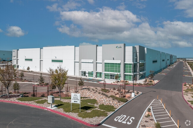
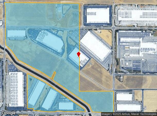
Property Record
6551 W Schulte Rd, Tracy, CA 95377
Current Lease Availabilities
NEARBY LISTINGS FOR SALE OR LEASE
Property Detail
6551 W Schulte Rd
209-120-09
17-FM 209-120-04/06/PT OF 03/PT TO 08 PER 16044280
Warehouse
San Joaquin
X
California
06077C0725F
378.88 AC
2025
Tracy
2025
Stockton/Modesto
005213
Stockton-Lodi, CA
641,000 SF
DEMOGRAPHICS near 6551 W Schulte Rd
1 Mile
3 Mile
5 Mile
2024 Total Population
34
10,572
83,527
2029 Population
38
11,518
88,748
Pop Growth 2024-2029
+ 11.76%
+ 8.95%
+ 6.25%
Average Age
37
34
36
2024 Total Households
10
3,131
23,933
HH Growth 2024-2029
+ 10.00%
+ 9.26%
+ 6.30%
Median Household Inc
$168,750
$127,088
$132,461
Avg Household Size
3.40
3.30
3.40
2024 Avg HH Vehicles
3.00
2.00
3.00
Median Home Value
$750,000
$701,948
$703,393
Median Year Built
2010
2011
2003
Nearby Places
- Restaurants
- Banks
- Shops
- Fitness
- Groceries
PUBLIC TRANSPORTATION
COMMUTER RAIL
Tracy Station (ACE Train - Altamont Corridor Express)
DRIVE
WALK
Distance
Tracy Station (ACE Train - Altamont Corridor Express)
21 min
7.6 mi
Tracy (Altamont Corridor Express - Altamont Commuter Express (ACE))
DRIVE
WALK
Distance
Tracy (Altamont Corridor Express - Altamont Commuter Express (ACE))
20 min
7.6 mi
AIRPORT
Stockton Metro
DRIVE
WALK
Distance
Stockton Metro
39 min
25.7 mi
Freight Ports
Port of Stockton
DRIVE
WALK
Distance
Port of Stockton
41 min
29.0 mi
Nearby Properties
Address
Land Use
TOTAL SIZE
Lot Size
Zoning
Address
Land Use
TOTAL SIZE
Lot Size
Zoning
1,120,082 SF
94.93 AC
AG40
Address
Land Use
TOTAL SIZE
Lot Size
Zoning
663,568 SF
158.06 AC
Address
Land Use
TOTAL SIZE
Lot Size
Zoning
1,034,066 SF
61.05 AC
Address
Land Use
TOTAL SIZE
Lot Size
Zoning
653,447 SF
66.62 AC
IG
Address
Land Use
TOTAL SIZE
Lot Size
Zoning
188,789 SF
92.24 AC
Address
Land Use
TOTAL SIZE
Lot Size
Zoning
202,577 SF
22.31 AC
IL
Address
Land Use
TOTAL SIZE
Lot Size
Zoning
483,967 SF
77.75 AC
Address
Land Use
TOTAL SIZE
Lot Size
Zoning
726,000 SF
32.29 AC
M1
Address
Land Use
TOTAL SIZE
Lot Size
Zoning
708,080 SF
83.08 AC
Address
Land Use
TOTAL SIZE
Lot Size
Zoning
403,560 SF
56.73 AC
Address
Land Use
TOTAL SIZE
Lot Size
Zoning
10.15 AC
PUD1
Address
Land Use
TOTAL SIZE
Lot Size
Zoning
490,000 SF
46 AC
IG
Address
Land Use
TOTAL SIZE
Lot Size
Zoning
22,726 SF
8.96 AC
PUD1
Address
Land Use
TOTAL SIZE
Lot Size
Zoning
67.04 AC
AG40
Address
Land Use
TOTAL SIZE
Lot Size
Zoning
960 SF
31.71 AC
RL
Address
Land Use
TOTAL SIZE
Lot Size
Zoning
616,700 SF
31.66 AC
IG
Address
Land Use
TOTAL SIZE
Lot Size
Zoning
148,663 SF
16.37 AC
Address
Land Use
TOTAL SIZE
Lot Size
Zoning
407,563 SF
18.64 AC
IL
Address
Land Use
TOTAL SIZE
Lot Size
Zoning
83.58 AC
IL
Address
Land Use
TOTAL SIZE
Lot Size
Zoning
103 AC
AG40
Address
Land Use
TOTAL SIZE
Lot Size
Zoning
127,018 SF
66.71 AC
IL
Address
Land Use
TOTAL SIZE
Lot Size
Zoning
148,645 SF
7.15 AC
IP
Address
Land Use
TOTAL SIZE
Lot Size
Zoning
3,000 SF
37.96 AC
IG
Address
Land Use
TOTAL SIZE
Lot Size
Zoning
139,273 SF
7.34 AC
IP
Address
Land Use
TOTAL SIZE
Lot Size
Zoning
34,532 SF
38.37 AC
AG40
Address
Land Use
TOTAL SIZE
Lot Size
Zoning
204,300 SF
9.50 AC
The World's #1 Commercial Real Estate Marketplace
Connect with us
© 2025 CoStar Group
The information above has been obtained from sources believed reliable. While we do not doubt its accuracy we have not verified it and make no guarantee, warranty or representation about it. It is your responsibility to independently confirm its accuracy and completeness. Any projections, opinions, assumptions, or estimates used are for example only and do not represent the current or future performance of the property. The value of this transaction to you depends on tax and other factors which should be evaluated by your tax, financial, and legal advisors. You and your advisors should conduct a careful, independent investigation of the property to determine to your satisfaction the suitability of the property for your needs.