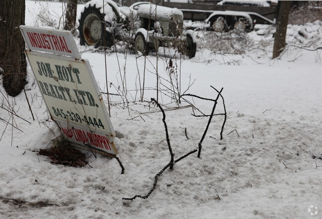
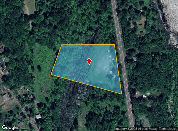
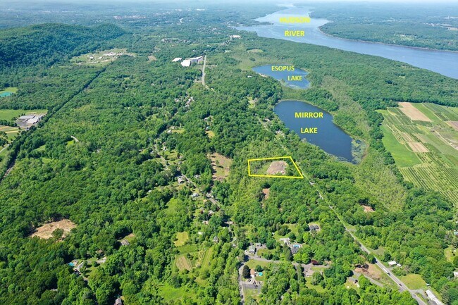
Property Record
676 Broadway, Ulster Park, NY 12487
NEARBY LISTINGS FOR SALE OR LEASE
Property Detail
676 Broadway
2200-063.004-0005-016.221-0000
Ulster
Miscresidentialimprovement
New York
A
16.221
36111C0630E
5.60 AC
2025
Newburgh/Kingston
2024
Other Market Areas
952600
Kingston, NY
DEMOGRAPHICS near 676 Broadway
1 Mile
3 Mile
5 Mile
2024 Total Population
848
5,515
28,593
2029 Population
846
5,418
28,281
Pop Growth 2024-2029
(0.24%)
(1.76%)
(1.09%)
Average Age
43
45
44
2024 Total Households
291
2,099
11,458
HH Growth 2024-2029
(0.34%)
(1.95%)
(1.21%)
Median Household Inc
$88,235
$90,436
$77,914
Avg Household Size
2.20
2.20
2.20
2024 Avg HH Vehicles
2.00
2.00
2.00
Median Home Value
$377,499
$294,556
$279,198
Median Year Built
1970
1967
1958
Nearby Places
- Restaurants
- Banks
- Shops
- Fitness
- Groceries
PUBLIC TRANSPORTATION
AIRPORT
New York Stewart International
DRIVE
WALK
Distance
New York Stewart International
44 min
32.2 mi
Freight Ports
Albany, NY Port
DRIVE
WALK
Distance
Albany, NY Port
73 min
58.4 mi
Nearby Properties
Address
Land Use
TOTAL SIZE
Lot Size
Zoning
Address
Land Use
TOTAL SIZE
Lot Size
Zoning
123,500 SF
407 AC
RF1
Address
Land Use
TOTAL SIZE
Lot Size
Zoning
162.70 AC
R20
Address
Land Use
TOTAL SIZE
Lot Size
Zoning
71,781 SF
6.50 AC
R40
Address
Land Use
TOTAL SIZE
Lot Size
Zoning
32,044 SF
51.24 AC
HP20
Address
Land Use
TOTAL SIZE
Lot Size
Zoning
88,000 SF
6.90 AC
GC
Address
Land Use
TOTAL SIZE
Lot Size
Zoning
133,760 SF
31.25 AC
LI
Address
Land Use
TOTAL SIZE
Lot Size
Zoning
10,581 SF
37.69 AC
HP20
Address
Land Use
TOTAL SIZE
Lot Size
Zoning
64,597 SF
200.40 AC
R40
Address
Land Use
TOTAL SIZE
Lot Size
Zoning
28,774 SF
9.11 AC
PUD
Address
Land Use
TOTAL SIZE
Lot Size
Zoning
32,934 SF
3 AC
R40
Address
Land Use
TOTAL SIZE
Lot Size
Zoning
9,167 SF
34.20 AC
HP20
Address
Land Use
TOTAL SIZE
Lot Size
Zoning
13,306 SF
72.74 AC
RA10
Address
Land Use
TOTAL SIZE
Lot Size
Zoning
46,948 SF
17.30 AC
R12
Address
Land Use
TOTAL SIZE
Lot Size
Zoning
77,650 SF
4.20 AC
LI
Address
Land Use
TOTAL SIZE
Lot Size
Zoning
24,956 SF
100 AC
WF
Address
Land Use
TOTAL SIZE
Lot Size
Zoning
80,688 SF
86.88 AC
WF
Address
Land Use
TOTAL SIZE
Lot Size
Zoning
2,696 SF
101.80 AC
R40
Address
Land Use
TOTAL SIZE
Lot Size
Zoning
1,120 SF
14 AC
R12
Address
Land Use
TOTAL SIZE
Lot Size
Zoning
9,325 SF
4 AC
GC
Address
Land Use
TOTAL SIZE
Lot Size
Zoning
130.56 AC
RF1
Address
Land Use
TOTAL SIZE
Lot Size
Zoning
25,526 SF
5.60 AC
R40
Address
Land Use
TOTAL SIZE
Lot Size
Zoning
90 AC
WF
Address
Land Use
TOTAL SIZE
Lot Size
Zoning
48,075 SF
3.30 AC
WF
Address
Land Use
TOTAL SIZE
Lot Size
Zoning
8,696 SF
0.23 AC
R12
Address
Land Use
TOTAL SIZE
Lot Size
Zoning
10,352 SF
9 AC
R40
Address
Land Use
TOTAL SIZE
Lot Size
Zoning
218.60 AC
R12
Address
Land Use
TOTAL SIZE
Lot Size
Zoning
4,500 SF
262 AC
HI
Address
Land Use
TOTAL SIZE
Lot Size
Zoning
5,304 SF
6.41 AC
HP20
Address
Land Use
TOTAL SIZE
Lot Size
Zoning
1,385 SF
82.82 AC
RF1
Address
Land Use
TOTAL SIZE
Lot Size
Zoning
5,418 SF
0.86 AC
R12
The World's #1 Commercial Real Estate Marketplace
Connect with us
© 2025 CoStar Group
The information above has been obtained from sources believed reliable. While we do not doubt its accuracy we have not verified it and make no guarantee, warranty or representation about it. It is your responsibility to independently confirm its accuracy and completeness. Any projections, opinions, assumptions, or estimates used are for example only and do not represent the current or future performance of the property. The value of this transaction to you depends on tax and other factors which should be evaluated by your tax, financial, and legal advisors. You and your advisors should conduct a careful, independent investigation of the property to determine to your satisfaction the suitability of the property for your needs.