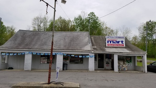
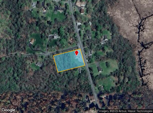
Property Record
689 State Route 32, Wallkill, NY 12589
NEARBY LISTINGS FOR SALE OR LEASE
-
-
View all Wallkill listings for lease on LoopNet.com
Property Detail
689 State Route 32
334600-004-000-0002-006.000-0000
Orange
Commercialnec
New York
X
6.000
36111C0900F
1.80 AC
2024
Newburgh
2024
Northern New Jersey
010101
Kiryas Joel-Poughkeepsie-Newburgh, NY
1,888 SF
DEMOGRAPHICS near 689 State Route 32
1 Mile
3 Mile
5 Mile
2024 Total Population
1,310
10,756
42,500
2029 Population
1,316
10,803
43,030
Pop Growth 2024-2029
+ 0.46%
+ 0.44%
+ 1.25%
Average Age
41
41
42
2024 Total Households
444
3,762
15,348
HH Growth 2024-2029
+ 0.45%
+ 0.48%
+ 1.28%
Median Household Inc
$107,169
$113,408
$105,295
Avg Household Size
2.90
2.80
2.60
2024 Avg HH Vehicles
3.00
2.00
2.00
Median Home Value
$334,195
$327,300
$308,770
Median Year Built
1984
1979
1976
Nearby Places
Map Layers
Map Styles
 Street
 Aerial
- Restaurants
- Banks
- Shops
- Fitness
- Groceries
PUBLIC TRANSPORTATION
COMMUTER RAIL
Beacon Station (Hudson Line - Metro-North Commuter Railroad Company (Metro-North))
DRIVE
WALK
Distance
Beacon Station (Hudson Line - Metro-North Commuter Railroad Company (Metro-North))
16 min
9.3 mi
AIRPORT
New York Stewart International
DRIVE
WALK
Distance
New York Stewart International
18 min
9.5 mi
Freight Ports
Port Newark Container Terminal
DRIVE
WALK
Distance
Port Newark Container Terminal
96 min
72.0 mi
SALE & LEASE HISTORY
LISTING DATE
SALE/LEASE

May 10, 2018
For Sale
Mar 13, 2018
For Sale
Jun 21, 2019
For Lease
Nearby Properties
Address
Land Use
TOTAL SIZE
Lot Size
Zoning
Address
Land Use
TOTAL SIZE
Lot Size
Zoning
50,840 SF
6.30 AC
BD40
Address
Land Use
TOTAL SIZE
Lot Size
Zoning
411.40 AC
Address
Land Use
TOTAL SIZE
Lot Size
Zoning
20 AC
Address
Land Use
TOTAL SIZE
Lot Size
Zoning
37.40 AC
Address
Land Use
TOTAL SIZE
Lot Size
Zoning
51.30 AC
Address
Land Use
TOTAL SIZE
Lot Size
Zoning
11,092 SF
102.50 AC
BD40
Address
Land Use
TOTAL SIZE
Lot Size
Zoning
3,128 SF
24.50 AC
RS1
Address
Land Use
TOTAL SIZE
Lot Size
Zoning
7.10 AC
Address
Land Use
TOTAL SIZE
Lot Size
Zoning
9,100 SF
1.80 AC
BD-40
Address
Land Use
TOTAL SIZE
Lot Size
Zoning
53,200 SF
4.50 AC
Address
Land Use
TOTAL SIZE
Lot Size
Zoning
32,500 SF
2.50 AC
Address
Land Use
TOTAL SIZE
Lot Size
Zoning
3.20 AC
Address
Land Use
TOTAL SIZE
Lot Size
Zoning
2,616 SF
14.50 AC
HR-1
Address
Land Use
TOTAL SIZE
Lot Size
Zoning
12,716 SF
2 AC
Address
Land Use
TOTAL SIZE
Lot Size
Zoning
55,000 SF
5.20 AC
Address
Land Use
TOTAL SIZE
Lot Size
Zoning
Address
Land Use
TOTAL SIZE
Lot Size
Zoning
5.40 AC
Address
Land Use
TOTAL SIZE
Lot Size
Zoning
4,016 SF
38.90 AC
Address
Land Use
TOTAL SIZE
Lot Size
Zoning
6,320 SF
1.50 AC
BD40
Address
Land Use
TOTAL SIZE
Lot Size
Zoning
42,258 SF
2.30 AC
Address
Land Use
TOTAL SIZE
Lot Size
Zoning
47,508 SF
2.10 AC
Address
Land Use
TOTAL SIZE
Lot Size
Zoning
10,480 SF
4.57 AC
RAG1
Address
Land Use
TOTAL SIZE
Lot Size
Zoning
Address
Land Use
TOTAL SIZE
Lot Size
Zoning
3,510 SF
31.30 AC
M-3
Address
Land Use
TOTAL SIZE
Lot Size
Zoning
3,510 SF
31.30 AC
M-3
Address
Land Use
TOTAL SIZE
Lot Size
Zoning
35,000 SF
2.60 AC
Address
Land Use
TOTAL SIZE
Lot Size
Zoning
15,292 SF
13.40 AC
BD40
Address
Land Use
TOTAL SIZE
Lot Size
Zoning
24,638 SF
4.40 AC
Address
Land Use
TOTAL SIZE
Lot Size
Zoning
3.60 AC
Address
Land Use
TOTAL SIZE
Lot Size
Zoning
3,600 SF
1 AC
BD40
The World's #1 Commercial Real Estate Marketplace
Connect with us
© 2026 CoStar Group
The information above has been obtained from sources believed reliable. While we do not doubt its accuracy we have not verified it and make no guarantee, warranty or representation about it. It is your responsibility to independently confirm its accuracy and completeness. Any projections, opinions, assumptions, or estimates used are for example only and do not represent the current or future performance of the property. The value of this transaction to you depends on tax and other factors which should be evaluated by your tax, financial, and legal advisors. You and your advisors should conduct a careful, independent investigation of the property to determine to your satisfaction the suitability of the property for your needs.