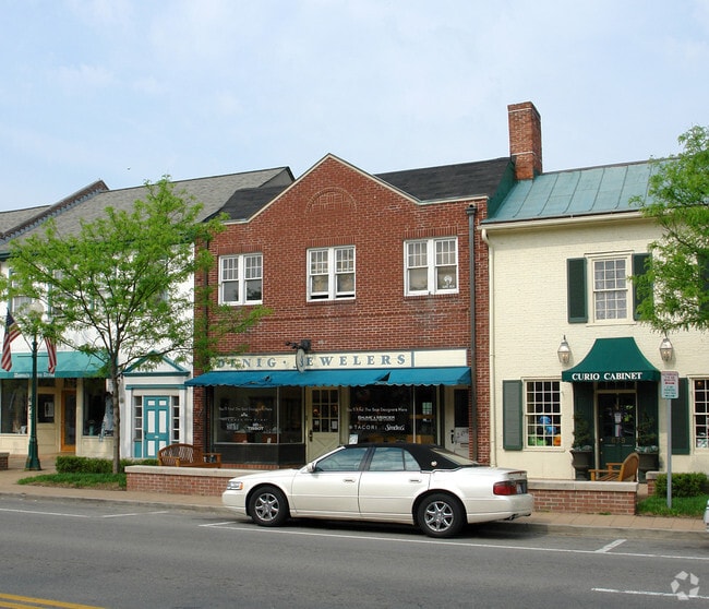
Property Record
677 N High St, Worthington, OH 43085
Current Lease Availabilities
NEARBY LISTINGS FOR SALE OR LEASE
Property Detail
677 N High St
Columbus, OH
Worthington
100-000335
677 N HIGH ST PT LOT 93 CITY OF WORTHINGTON
Storebuilding
Franklin
X
Ohio
39049C0159K
93
2024
0.05 AC
2025
Worthington
006710
Columbus
4,788 SF
DEMOGRAPHICS near 677 N High St
1 mile
3 mile
5 mile
2024 Total Population
9,866
104,493
312,789
2029 Population
9,785
103,746
314,187
Pop Growth 2024-2029
(0.82%)
(0.71%)
+ 0.45%
Average Age
41
39
38
2024 Total Households
4,091
45,110
132,672
HH Growth 2024-2029
(0.86%)
(0.70%)
+ 0.51%
Median Household Inc
$102,711
$70,162
$70,960
Avg Household Size
2.40
2.20
2.30
2024 Avg HH Vehicles
2.00
2.00
2.00
Median Home Value
$364,008
$286,599
$276,803
Median Year Built
1957
1971
1976
Nearby Places
Map Layers
Map Styles
 Street
 Aerial
Transit
 Traffic
 Biking
Places
Listings with unknown addresses are not visible on the map
- Restaurants
- Banks
- Shops
- Fitness
- Groceries
PUBLIC TRANSPORTATION
AIRPORT
John Glenn Columbus International
Drive
Walk
Distance
John Glenn Columbus International
22 min
15.3 mi
Rickenbacker International
Drive
Walk
Distance
Rickenbacker International
38 min
24.6 mi
Nearby Properties
Address
Land Use
TOTAL SIZE
Lot Size
Zoning
Address
Land Use
TOTAL SIZE
Lot Size
Zoning
182,845 SF
325.61 AC
Address
Land Use
TOTAL SIZE
Lot Size
Zoning
133,425 SF
0.44 AC
Address
Land Use
TOTAL SIZE
Lot Size
Zoning
320,155 SF
84.68 AC
Address
Land Use
TOTAL SIZE
Lot Size
Zoning
234,504 SF
5.40 AC
Address
Land Use
TOTAL SIZE
Lot Size
Zoning
206,724 SF
7.60 AC
Address
Land Use
TOTAL SIZE
Lot Size
Zoning
561,921 SF
6.81 AC
Address
Land Use
TOTAL SIZE
Lot Size
Zoning
356,770 SF
2.65 AC
Address
Land Use
TOTAL SIZE
Lot Size
Zoning
286,169 SF
11.08 AC
Address
Land Use
TOTAL SIZE
Lot Size
Zoning
425,872 SF
10.05 AC
Address
Land Use
TOTAL SIZE
Lot Size
Zoning
261,872 SF
53.89 AC
Address
Land Use
TOTAL SIZE
Lot Size
Zoning
413,781 SF
78.36 AC
Address
Land Use
TOTAL SIZE
Lot Size
Zoning
244,602 SF
27.30 AC
Address
Land Use
TOTAL SIZE
Lot Size
Zoning
162,728 SF
4.80 AC
Address
Land Use
TOTAL SIZE
Lot Size
Zoning
187,562 SF
8.76 AC
Address
Land Use
TOTAL SIZE
Lot Size
Zoning
62,702 SF
38.69 AC
Address
Land Use
TOTAL SIZE
Lot Size
Zoning
273,112 SF
13.97 AC
Address
Land Use
TOTAL SIZE
Lot Size
Zoning
86,934 SF
8.80 AC
Address
Land Use
TOTAL SIZE
Lot Size
Zoning
273,264 SF
7.35 AC
Address
Land Use
TOTAL SIZE
Lot Size
Zoning
147,582 SF
5.75 AC
Address
Land Use
TOTAL SIZE
Lot Size
Zoning
168,427 SF
6.70 AC
Address
Land Use
TOTAL SIZE
Lot Size
Zoning
170,237 SF
97.38 AC
Address
Land Use
TOTAL SIZE
Lot Size
Zoning
368,077 SF
7.87 AC
Address
Land Use
TOTAL SIZE
Lot Size
Zoning
184,756 SF
23.53 AC
Address
Land Use
TOTAL SIZE
Lot Size
Zoning
148.89 AC
Address
Land Use
TOTAL SIZE
Lot Size
Zoning
148,499 SF
18.03 AC
Address
Land Use
TOTAL SIZE
Lot Size
Zoning
150,468 SF
24.57 AC
Address
Land Use
TOTAL SIZE
Lot Size
Zoning
111,168 SF
19.43 AC
Address
Land Use
TOTAL SIZE
Lot Size
Zoning
352,730 SF
17.94 AC
Address
Land Use
TOTAL SIZE
Lot Size
Zoning
242,825 SF
3.22 AC
Address
Land Use
TOTAL SIZE
Lot Size
Zoning
187,225 SF
10.28 AC
The World's #1 Commercial Real Estate Marketplace
Connect with us
© 2026 CoStar Group
The information above has been obtained from sources believed reliable. While we do not doubt its accuracy we have not verified it and make no guarantee, warranty or representation about it. It is your responsibility to independently confirm its accuracy and completeness. Any projections, opinions, assumptions, or estimates used are for example only and do not represent the current or future performance of the property. The value of this transaction to you depends on tax and other factors which should be evaluated by your tax, financial, and legal advisors. You and your advisors should conduct a careful, independent investigation of the property to determine to your satisfaction the suitability of the property for your needs.