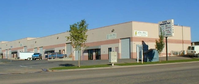
Property Record
653 N 3050 E, Saint George, UT 84790

Current Lease Availabilities
Property Detail
653 N 3050 E
0268881
S: 22 T: 42S R: 15W BEG AT PT N0*5217 W 444.62 FT ALG C/S/L FM C1/4 COR SEC 22 T42S R15W; TH N0*5217 W 222.31 FT ALG C/S/L; TH N89*4106 E 560 FT TO PT ON W R/W/L OF MILL CREEK INDUSTRIAL PK RD; TH S0*5217 E 222.31 FT ALG SD R/W/L; TH S89*4106 W 560 F
Commercialnec
Washington
M-1
Utah
B and X Area of moderate flood hazard, usually the area between the limits of the 100-year and 500-year floods.
2.86 AC
2024
Cedar City & St George
2025
Other Market Areas
271101
St. George, UT
36,825 SF
NEARBY LISTINGS FOR SALE OR LEASE
DEMOGRAPHICS near 653 N 3050 E
1 mile
3 mile
5 mile
2025 Total Population
11,136
54,129
99,351
2030 Population
12,110
59,512
109,122
Pop Growth 2025-2030
+ 8.75%
+ 9.94%
+ 9.83%
Average Age
38
39
39
2025 Total Households
3,894
18,691
33,709
HH Growth 2025-2030
+ 9.48%
+ 10.36%
+ 10.19%
Median Household Inc
$68,777
$73,995
$76,317
Avg Household Size
2.80
2.80
2.80
2025 Avg HH Vehicles
2.00
2.00
2.00
Median Home Value
$439,749
$528,467
$557,055
Median Year Built
2000
2005
2003
Nearby Places
Map Layers
Map Styles
 Street
 Aerial
Layers
 Traffic
 Biking
Places
Listings with unknown addresses are not visible on the map
- Restaurants
- Banks
- Shops
- Fitness
- Groceries
PUBLIC TRANSPORTATION
AIRPORT
St George Regional
Drive
Walk
Distance
St George Regional
12 min
6.4 mi
Freight Ports
Port of Long Beach
Drive
Walk
Distance
Port of Long Beach
445 min
405.6 mi
Nearby Properties
Address
Land Use
TOTAL SIZE
Lot Size
Zoning
Address
Land Use
TOTAL SIZE
Lot Size
Zoning
1,120,988 SF
52.22 AC
PDCOM
Address
Land Use
TOTAL SIZE
Lot Size
Zoning
319,351 SF
31.39 AC
Address
Land Use
TOTAL SIZE
Lot Size
Zoning
319,351 SF
31.39 AC
PD
Address
Land Use
TOTAL SIZE
Lot Size
Zoning
1,319 SF
549.51 AC
Address
Land Use
TOTAL SIZE
Lot Size
Zoning
118,603 SF
16.56 AC
Address
Land Use
TOTAL SIZE
Lot Size
Zoning
141,151 SF
15 AC
PDCOM
Address
Land Use
TOTAL SIZE
Lot Size
Zoning
230,880 SF
25.58 AC
C-2
Address
Land Use
TOTAL SIZE
Lot Size
Zoning
87,826 SF
37.27 AC
Address
Land Use
TOTAL SIZE
Lot Size
Zoning
66,506 SF
15.12 AC
Address
Land Use
TOTAL SIZE
Lot Size
Zoning
97,572 SF
10.51 AC
PD
Address
Land Use
TOTAL SIZE
Lot Size
Zoning
91,517 SF
8.96 AC
C2
Address
Land Use
TOTAL SIZE
Lot Size
Zoning
84,384 SF
6.34 AC
C2
Address
Land Use
TOTAL SIZE
Lot Size
Zoning
88,445 SF
3.28 AC
C2
Address
Land Use
TOTAL SIZE
Lot Size
Zoning
86,875 SF
77.53 AC
Address
Land Use
TOTAL SIZE
Lot Size
Zoning
153,140 SF
17.17 AC
C-3
Address
Land Use
TOTAL SIZE
Lot Size
Zoning
120,219 SF
11.88 AC
Address
Land Use
TOTAL SIZE
Lot Size
Zoning
67,974 SF
7.04 AC
Address
Land Use
TOTAL SIZE
Lot Size
Zoning
76,907 SF
4 AC
PDCOM
Address
Land Use
TOTAL SIZE
Lot Size
Zoning
72,862 SF
3.20 AC
Address
Land Use
TOTAL SIZE
Lot Size
Zoning
99,566 SF
5.64 AC
Address
Land Use
TOTAL SIZE
Lot Size
Zoning
137,662 SF
7.81 AC
PD
Address
Land Use
TOTAL SIZE
Lot Size
Zoning
69,421 SF
5.73 AC
PDCOM
Address
Land Use
TOTAL SIZE
Lot Size
Zoning
34,097 SF
5.90 AC
Address
Land Use
TOTAL SIZE
Lot Size
Zoning
125,208 SF
4.15 AC
PDCOM
Address
Land Use
TOTAL SIZE
Lot Size
Zoning
58,937 SF
4.47 AC
C2
Address
Land Use
TOTAL SIZE
Lot Size
Zoning
135,592 SF
11.24 AC
PDCOM
Address
Land Use
TOTAL SIZE
Lot Size
Zoning
111,865 SF
5 AC
M-2
Address
Land Use
TOTAL SIZE
Lot Size
Zoning
71,533 SF
6.48 AC
C3
Address
Land Use
TOTAL SIZE
Lot Size
Zoning
88,962 SF
8.35 AC
C-3
Address
Land Use
TOTAL SIZE
Lot Size
Zoning
54,754 SF
3.17 AC
AP
The World's #1 Commercial Real Estate Marketplace
Connect with us
© 2026 CoStar Group
The information above has been obtained from sources believed reliable. While we do not doubt its accuracy we have not verified it and make no guarantee, warranty or representation about it. It is your responsibility to independently confirm its accuracy and completeness. Any projections, opinions, assumptions, or estimates used are for example only and do not represent the current or future performance of the property. The value of this transaction to you depends on tax and other factors which should be evaluated by your tax, financial, and legal advisors. You and your advisors should conduct a careful, independent investigation of the property to determine to your satisfaction the suitability of the property for your needs.